Accessibility Evaluation 1-km Ruster
Dataset Development of Public Charging Stations for New Energy Vehicles in Beijing (2020)
Huang, J.1, 2* Gao, Y.1, 2
1. Institute of Geographic Sciences and Natural Resources
Research & Key Laboratory of Regional Sustainable Development Modeling,
Chinese Academy of Sciences, Beijing 100101, China;
2. College of Resources and
Environment, University of Chinese Academy of Sciences, Beijing 100049, China
Abstract: Accessibility
represents the ease or difficulty of reaching a particular location and
overcoming spatial distances and is a commonly used indicator in the study of
public service facilities. Based on the spatial distribution of public charging
station sites, population distribution data, point of interest data, and other
relevant information of the Sixth Ring Road of Beijing in 2020, we used the
two-step floating catchment area, cumulative opportunity, and spatial
clustering methods to calculate the accessibility of public charging facilities
for car travel at the kilometer grid level, as well as the cumulative
opportunity count for walking activities after charging completion.
Consequently, we developed a dataset for evaluating the accessibility of public
charging stations within the Sixth Ring Road of Beijing in 2020. The dataset
includes the following: (1) accessibility data for electric vehicles to reach
public charging stations from the center of each 1 km grid; (2) the cumulative
opportunity count of various types of public service facilities reachable by each
vehicle owner from the center of each 1 km grid; and (3) comprehensive
evaluation results of accessibility for both car travel and foot travel. The
dataset was archived in .shp
format, consisting of eight data files with data size of 963 KB (compressed into
one file, 153 KB).
Keywords: residential travel; accessibility; public service facilities;
electric vehicles
DOI: https://doi.org/10.3974/geodp.2023.01.07
CSTR: https://cstr.escience.org.cn/CSTR:20146.14.2023.01.07
Dataset Availability Statement:
The
dataset supporting this paper was published and is accessible through the Digital Journal of
Global Change Data Repository at:
https://doi.org/10.3974/geodb.2023.04.02.V1 or
https://cstr.escience.org.cn/CSTR:20146.11.2023.04.02.V1.
1 Introduction
In
the context of industrial transformation and carbon neutrality, the layout of
new types of infrastructure is important for socioeconomic development[1].
As a strategically supported emerging industry, megacities are gradually
increasing their market share of new energy vehicles[2]. Public
charging stations for new electric vehicles represent a new type of urban
infrastructure. The suitable allocation, quantity, and layout of charging
stations can support new energy vehicle users, improve charging convenience,
and increase the popularization and adoption of new energy vehicles, thus
playing a crucial role in sustainable urban development and the construction of
suitableransportation systems.
Recently, the
development, planning, construction, and layout of charging stations have
become popular research topics. Related studies have focused on policy making[3],
charging technology, charging capacity allocation[4], optimization
of algorithms for energy conservation and emission reduction[5], as
well as power load and charging time[6]. Accessibility is an
essential indicator of the public service nature of new energy charging
stations. Studies on accessibility include the evaluation of spatial coverage,
equality, and the efficiency of public service facilities from a geographical
perspective. At the technical and methodological level, various studies have
been conducted using gravity model (which consider spatial distance and
facility quantity), cumulative opportunity model, isochrone model,
distance-based model[7?C9], balance coefficient modelthat
consider supply-demand relationships), or the two-step floating catchment area
(2SFCA) model[9,10]. Results from previous studies indicate that, by
introducing distance decay, the cumulative opportunity method can effectively
increase the accuracy of facility accessibility measurements[11].
The 2SFCA model, with a variable effective service radius, can effectively
reflect regional accessibility influenced by supply, demand, and distance[10].
At the practical
level, after the proposal of the ??new infrastructure?? and ??dual-carbon?? goals
in 2020, the market share of new energy vehicles in China has increased
significantly, and local governments have begun to pay more attention to the
construction of public charging stations. However, the assessment of public
charging-station accessibility is often based on community-based capacity
planning, which lacks precise evaluations at the city level and, from a
detailed perspective, makes it challenging to accurately assess the service
level of charging stations.
Thus, a
fine-scale evaluation of the accessibility of public charging infrastructure is
of great significance for the further development of the new energy vehicle
industry. Within this context, the developed dataset provides quantitative
results of public charging station accessibility at the kilometer grid scale
within the Sixth Ring Road of Beijing and resolves the issue of mismatched
supply and demand in charging infrastructure services and provides scientific
support for optimizing the layout of public charging facilities for new energy
vehicles.
2 Metadata of the Dataset
The
metadata of the Accessibility evaluation dataset of public charging stations of
new energy vehicles in Beijing is summarized in Table 1[12]. It
includes the dataset full name, short name, authors, year of the dataset, temporal
resolution, spatial resolution, data format, data size, data files, data
publisher, and data sharing policy, etc.
3 Methods
3.1 Data Sources
The developed
dataset has a 1 km ?? 1 km grid and covers the area within the Sixth Ring Road
of Beijing. The following data sources were used for the dataset development.
Table 1 Metadata
summary of the Accessibility evaluation dataset of public charging stations of
new energy vehicles in Beijing
|
Items
|
Description
|
|
Dataset
full name
|
Accessibility
evaluation dataset of public charging stations of new energy vehicles in
Beijing
|
|
Dataset
short name
|
AccessibilityofBeijingchargingpile_2020
|
|
Authors
|
Huang, J. CVH-4108-2022, Institute of Geographic Sciences and Natural
Resources Research, huangjie@igsnrr.ac.cn
Gao, Y. GSM-9571-2022, Institute of Geographic Sciences and Natural
Resources Research, gaoyang212@mails.ucas.ac.cn
|
|
Geographical
region
|
Within
the sixth ring road of Beijing city
|
|
Year
|
2020 Spatial
resolution 1 km ´ 1 km
|
|
Data
format
|
.shp Data
size 153 KB (after compression)
|
|
|
Data
files
|
AccessibilityofBeijingchargingpile_2020
|
|
Foundation
|
National
Social Science Fund Major Project (20&ZD099)
|
|
Data
publisher
|
Global Change Research Data Publishing &
Repository, http://www.geodoi.ac.cn
|
|
Address
|
No.
11A, Datun Road, Chaoyang District, Beijing 100101, China
|
|
Data
sharing policy
|
Data from
the Global Change Research Data Publishing & Repository includes metadata, datasets (in the Digital Journal of Global Change Data Repository), and
publications (in the Journal of Global Change Data & Discovery). Data sharing policy
includes: (1) Data are openly available and can be free downloaded via the
Internet; (2) End users are encouraged to use Data subject to
citation; (3) Users, who are by definition also value-added service
providers, are welcome to redistribute Data subject to written permission
from the GCdataPR Editorial Office and the issuance of a Data redistribution
license; and (4) If Data are used to compile new
datasets, the ??ten per cent principal?? should be followed such that Data
records utilized should not surpass 10% of the new dataset contents, while
sources should be clearly noted in suitable places in the new dataset[13]
|
|
Communication and
searchable system
|
DOI, CSTR, Crossref, DCI, CSCD, CNKI,
SciEngine, WDS/ISC, GEO
|
(1) Vehicle
ownership, public charging station construction, and residential travel
destinations were obtained from the 2021 Beijing annual report on
transportation development[14].
(2) Socioeconomic
statistical data, such as the total population and vehicle ownership, were
obtained from the Beijing Statistical Yearbook 2021, and
administrative boundary data were sourced from the Resource and Environmental
Science and Data Center of the Chinese Academy of Sciences.
(3) Point of
interest (POI) data was obtained from the Amap Application Programming
Interface (API), including categories such as healthcare, schools, dining,
entertainment, residential areas, companies, and charging stations. Data fields
included the name, time (August 16, 2021), latitude, longitude, and POI
category. Subsequently, we referred to mobile applications such as State Grid
and Xingxing Charging to screen and verify the distribution of the charging
stations.
(4) Road network
data was downloaded from the OpenStreetMapwebsite
and pre-processed using geospatial information technology. Roads were
classified into different levels, and speed limits were set based on road
types, including local roads (20 km/h), secondary roads (40 km/h), main roads
(60 km/h), and motorways (80 km/h). Travel time was used as a cost in the
dataset creation process.
(5) The 2020
population distribution data, obtained from Worldpop. Using
integrated household surveys, microdata, satellite, and other data sources,
population estimation values were generated through a random forest algorithm.
3.2 Data Processing
Charging
and travel activities primarily involved the following two processes: vehicle
owners driving to search for charging stations near their destinations, and
vehicle owners walking to charging stations during the charging process. To
search for charging stations while driving, a Gaussian distribution function with
distance decay was used. The center point of the grid was considered the
starting point, while the charging station was considered the endpoint. Using a
two-step movement search algorithm, the number of reachable charging stations
during the travel chain process was calculated to obtain evaluation results of
charging station accessibility. For walking activities, a third-degree
polynomial function was used for distance decay. The charging station was
considered the starting point, with the center point of the grid being the
endpoint. A cumulative opportunity algorithm was used to calculate the number
of reachable facilities of various types during the walking part of the travel
chain process, yielding evaluation results of walking activity accessibility.
Finally, based on the principle of equal intervals, the evaluation results of
the two steps were divided into nine categories to provide numerical and
categorical outputs for charging station accessibility.
3.2 Technical Roadmap
We
developed a technical roadmap for creating a dataset to evaluate the
accessibility of public charging stations within the Sixth Ring Road of Beijing
and to analyze the spatial distribution characteristics of public charging
stations (Figure 1). The technical
roadmap included the following steps:
(1) We obtained,
drew, and integrated basic data such as administrative districts, ring road
boundaries, population distribution, POIs, and graded road network data in
Beijing.
(2) Divide the smallest evaluation unit. Our dataset
uses a 1 km ?? 1 km grid as the smallest evaluation unit, allowing for the
aggregation of spatial data, such as population distribution and POI, into the
evaluation grid. The facility supply and demand of each grid were adjusted
using the total number of cars, total population, facility size, and total data
quantity.
(3) A vector
network dataset was created, and calculations were performed using ArcGIS.
(4) Distance
decay functions were developed for the driving and walking stages and the POI
at different distances.
(5) A two-step
mobile algorithm and cumulative opportunity model were used to calculate the
accessibility of charging stations within the evaluation grid.
(6)
Equi-frequency binning was used to divide the two-stage evaluation results into
high, medium, and low levels and to connect the results of the two steps to
obtain the dataset for evaluating the accessibility of public charging
stations.
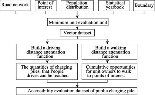
Figure 1 Technology
roadmap for the dataset development
4 Data Results and Validation
4.1 Data Composition
The accessibility evaluation dataset of public charging
stations of new energy vehicles in Beijing consists of a single dataset based
on the accessibility evaluation 1 km grid vector data (.shp). The attribute
fields of the dataset included (1) data on the accessibility of public charging
piles for each electric vehicle within the Sixth Ring Road of Beijing,
departing from the 1 km grid, with the field name PA; (2) the cumulative
opportunity count of various public service facilities reachable by each vehicle
owner departing from the 1 km grid within the Sixth Ring Road of Beijing,
weighted by the different proportion of Beijing residents?? travel purposes and
calculated as the Z-score, with the field name comprehensive cumulative
opportunity (OA); and (3) a comprehensive evaluation of accessibility across
the two stages of driving and walking by vehicle owners, including a total of
nine levels, such as low-low, low-medium, and low-high, with the field name
Combi1_2.
4.2 Data Results
|
Figure 2 Distribution map of the accessibility
of charging stations in Beijing city
|
Based
on the 2020 population distribution and stock of new energy vehicles (NEVs) in
Beijing, we calculated a total of 312,400 NEVs within the Sixth Ring Road. The
results of the developed dataset show a significant variation in the overall
accessibility patterns of charging stations across different areas (Figure 2).
In the region with the highest accessibility to public charging stations in
Beijing, each vehicle, on average, had access to 0.148 public charging
stations, whereas in the lowest accessibility region, this decreased to 0.004
stations per vehicle, with an average of 0.09 charging stations available per
vehicle. From a citywide perspective, the spatial distribution of charging
stations in Beijing aligns with the hierarchical structure of the city??s
transportation network, forming various concentric circles[15]. The
characteristics of the concentric circles in terms of charging station
accessibility per vehicle are as follows: (1) The first concentric circle
corresponds to the area within the Fourth Ring Road. The average number of
accessible charging stations within the Fourth Ring Road is 0.135, which is
higher than that areas outside the Fourth Ring Road, while the variation within
this region is relatively small. (2) Charging station accessibility per vehicle
significantly decreased beyond the Fourth Ring Road, with an average value of
0.11 between the Fourth and Fifth Ring Roads. The second concentric circle
appears between the Fourth Ring Road and the edge of the Fifth Ring Road, with
accessibility ranging from 0.09 to 0.12. (3) Beyond the Fifth Ring Road,
accessibility values rapidly declined, forming a three-tiered concentric
circle pattern. Within the region between the Fifth and Sixth Ring Roads, the
average number of accessible charging stations was 0.07. Furthermore, compared
with the western side, there was a slight increase in charging station
accessibility per vehicle on the eastern side of the Fifth Ring Road.
In this study, data
were obtained from the 2020 Beijing Resident Travel Survey data[14].
Travel purposes was categorized based on facility attributes, including commuting,
shopping, dining, leisure, and other primary activity facilities. Furthermore,
based on the travel frequency of the total population[14], the
accessibility of charging stations to activity facilities was accumulated and
weighted according to the proportion of trips, resulting in the calculation of
OA for pedestrian activities. The spatial distribution data of OA (Figure 3)
revealed the following: (1) A global Moran's I value for OA of 0.83 with a
Z-score of 56.41 indicates a significant clustering pattern of OA within the
Sixth Ring Road in Beijing at a 99% confidence level. (2) A mean OA value of 0.41,
with a minimum of 0 and a maximum of 11.41. OA exhibited a distribution pattern
in which the central area had higher values than the peripheral areas, and the
northern region had higher values than those of the southern region. High-value
clusters were concentrated in the northeast region within the Fourth Ring Road
in Beijing, whereas low-value clusters were found outside the Fourth Ring Road
in areas with lower urban road density. (3) At the municipal level, the eastern
and western urban districts of Beijing had the highest mean OA values, followed
by Chaoyang, Haidian, and Fengtai, whereas Shijingshan and Mentougou had the
lowest values. (4) At the street level, areas within the Second Ring Road such
as Taoranting, Temple of Heaven, Shichahai, Jingshan, and Donghuamen had lower
OA values than those of the surrounding areas. Conversely, areas such as
Xincun, Dongtiejiaying, Shangjie, Wangjing, and Qinghe had higher OA values
than those of the surrounding areas[15].
|

Figure 3 Map of cumulative opportunity
score
distribution
in Beijing city
|
Based on previously calculated Potential
Accessibility (PA) and comprehensive cumulative
opportunity (OA), we
divided the results into three categories (low, medium, and high) using
equal-frequency partitioning. The two-step results were then combined to create
nine comprehensive evaluation categories. The combined evaluation results
represent different levels of vehicular and pedestrian accessibility, with the
??low-high?? region indicating low vehicular accessibility and high pedestrian
accessibility, while the ??high-low?? region indicates the opposite[15]
(Figure 4). (1) The ??high-low?? region was distributed around the Fifth Ring
Road, while the ??low-high?? region appeared in the peripheral areas near the
Sixth Ring Road. This indicates that in the region between the Fifth and Sixth
Ring Roads in Beijing, certain areas have formed regional centers for
employment and life services; however, the supply level of charging facilities
cannot match the increased demand resulting from the growth of activity
facilities. (2) The ??low-low?? region of the comprehensive evaluation value
corresponded closely to the cluster of low pedestrian values, while the
??high-high?? region overlapped with the high-value areas of pedestrian cumulative
opportunities. This indicates that the central area of the city is supplemented
with both public charging piles and various types of POI facilities, whereas
the outer ring area exhibits an imbalance in the distribution of these
facilities. (3) The overall evaluation results indicate that high-value areas
exhibited central clustering and an axial radiating distribution. In the outer
ring area (between the Fifth and Sixth Ring Roads), the distribution of public
service facilities is relatively sparse, with the majority of public charging
piles concentrated around urban motorways with a low density of
installations. Therefore, in areas without charging station coverage, it is
inconvenient for residents with new energy vehicles to access public service
facilities. However, in the inner ring area (within the Fourth Ring Road),
there was no significant difference between the two stages of charging facility
accessibility results owing to the higher density of residential and commercial
facilities within the Fourth Ring Road in Beijing, which has more integrated
public charging stations.
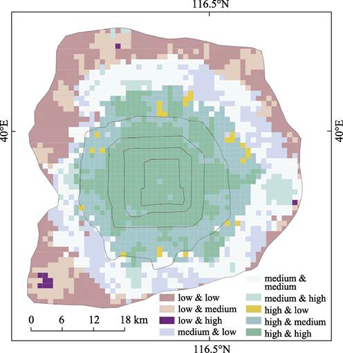
Figure 4 Map of accessibility of public
charging piles in Beijing city
5 Discussion and Conclusion
The requirements for industrial structure upgrading and
improvement of living environment quality are clearly defined in the 14th
Five-Year Plan and the ??Dual Carbon?? goals. The layout of public charging
stations, as a fundamental element of the new energy vehicle industry, directly
affects the convenience of using new energy vehicles through factors such as
spatial distribution, service coverage, and accessibility, thereby influencing
the commercialization of new
energy vehicles. The developed dataset is based on the complete travel chain of
vehicle owners charging their vehicles and analyzes the spatial correlations
between public charging stations, driving destinations, and pedestrian activity
destinations to calculate the fine-scale spatial accessibility of charging
facilities in Beijing. In terms of methodology, we used a two-step mobile
search method and the cumulative opportunity method for analysis to accurately
reveal the spatial distribution patterns of charging facilities. To some
extent, the developed dataset improves the methodological system for studying
the spatial accessibility of public charging piles and provides new research
material and data support to assist in the layout and optimization of new
infrastructure in Beijing. Notably, considering the varying proportions of new
energy vehicle travel in different regions together with the wide distribution
of private charging stations, the combination of different modes of
transportation, and different travel periods, all of which affect the charging
pattern, this dataset does not fully explore and analyze all relevant
influencing factors. Instead, it provides a basic description of the spatial
accessibility distribution of public charging piles within the Sixth Ring Road
in Beijing, based on the supply-demand balance and the weighted adjustment of
charging pile accessibility according to multipurpose travel. Therefore, this
dataset provides a foundation for further research on optimizing the layout of
new energy charging piles. However, future related studies and data development
still need to further collect and develop the spatial distribution of charging
pile accessibility under complex travel conditions. In addition, future
research avenues should include in-depth investigations of the spatial and
temporal mismatch between new infrastructure and residents?? needs in major
cities in China and propose targeted optimization and simulation schemes. This
will serve as fundamental research for the design and optimization of new
infrastructure in China and contribute to the achievement of the ??Dual Carbon??
goals.
Author Contributions
Huang, J. designed the overall development of the
dataset; Gao, Y. collected and processed the charging station evaluation data
and drafted the data paper; Huang, J. reviewed, supervised, edited, and
improved the data paper.
Conflicts of Interest
The
authors declare no conflicts of interest.
References
[1]
Lin, B., Liu, X. China??s carbon
dioxide emissions under the urbanization process: influence factors and
abatement policies [J]. Economic Research Journal, 2010, 45(8): 66‒78.
[2]
Ma, J., Liu, X., Chen, Y., et
al. Current status and countermeasures for China??s new energy automobile
industry and technology development [J]. China Journal of Highway and
Transport, 2018, 31(8): 1‒19.
[3]
Tang, B., Wang, X., Wang, B., et
al. Analysis and prospect of the development level of China??s new energy
vehicle industry [J]. Journal of Beijing
Institute of Technology: Social Sciences Edition, 2019, 21(2): 6‒11.
[4]
Pantelidis, T. P., Li, L., Ma,
T. Y., et al. A node-charge graph-based online carshare rebalancing
policy with capacitated electric charging [J]. Transportation Science,
2022, 56(3): 654‒676.
[5]
Zhang, D., Jiang, J., Zhang,
W., et al. Optimal configuration of charging piles for electric taxis
[J]. Transactions of China Electrotechnical Society, 2015, 31(18):
181‒188.
[6]
Fang, Z., Zhang, J., Sun, Y., et
al. Study on quantity planning of charging piles considering
multi-objective constraints [J]. Power System Technology, 2020, 44(2):
704‒712.
[7]
Wang, F. Measurement,
optimization, and impact of health care accessibility: a methodological review
[J]. Annals of the Association of American
Geographers, 2012, 102(5): 1104‒1112.
[8]
Wang, F., Wang, S., Li, M.
Dynamic evolution and function optimization of green open space system in
Luoyang [J]. Geographical Research,
2012, 31(7): 1209‒1223.
[9]
Wu, H., Levinson, D. Unifying
access [J]. Transportation Research Part D: Transport and Environment, 2020, 83: 102355.
[10]
Zhao, P., Luo, J., Hu, H.
Spatial match between residents?? daily life circle and public service
facilities using big data analytics: a case of Beijing [J]. Progress in
Geography, 2021, 40(4): 541‒553.
[11]
Mora, R., Truffello, R.,
Oyarz??n, G. Equity and accessibility of cycling infrastructure: an analysis of
Santiago de Chile [J]. Journal of Transport Geography, 2021, 91: 102964.
[12]
Huang, J., Gao, Y.
Accessibility evaluation dataset of public charging stations of new energy
vehicles in Beijing [J/DB/OL]. Digital Journal of Global Change Data
Repository, 2023. https://doi.org/10.3974/ geodb.2023.04.02.V1. https://cstr.escience.org.cn/CSTR:20146.11.2023.04.02.V1.
[13]
GCdataPR Editorial Office.
GCdataPR data sharing policy [OL]. https://doi.org/10.3974/dp.policy.2014.05
(Updated 2017).
[14]
Beijing Transportation
Development Research Institute. Annual report of Beijing transportation
development in 2021 [EB/OL]. https://www.bjtrc.org.cn/List/index/cid/7.html,
2021-10-08.
[15]
Huang, J., Gao, Y., Fu, Xiao, et al. Accessibility of public electric vehicle
charging stations based on trip chains: a case study in Beijing [J]. Geographical Research, 2022, 41(12): 3305‒3317.