Dataset Development on Wild Yaks
Distribution and Potential Habitat Analysis on the Qiangtang Plateau
Wei, Z. Q.1,
2 Xu, Z. R.3* Wei, X. W.3 Xian, Y. F.3
1.
China Academy of Building Research, Beijing 100013, China;
2.
China University of Geosciences Beijing, Beijing 100083, China;
3. Institute of Geographic
Sciences and Natural Resources Research, Chinese Academy of Sciences, Beijing
100101, China
Abstract:
As a rare and
endangered wild species on the Qinghai-Xizang Plateau, the wild yaks (Bos mutus) are categorized as a
vulnerable (VU) species by the International Union for Conservation of Nature
(IUCN) and are designated as a first-class protected animal in China. The
habitats of wild yaks are characterized by their inaccessibility, harsh natural
conditions. Coupled with their small population size and strong tendency to
avoid human contact, there is currently a dearth of distribution point data for
wild yaks, and the boundaries of their habitats remain ill-defined. This
situation poses significant challenges to the precise conservation of wild
yaks. Consequently, this study selected the Qiangtang Plateau, the core
distribution area of wild yaks, as the study area. A combined approach of field
transect surveys and model simulations was employed to document the current
distribution of wild yaks?? habitats. Furthermore, future ecosystem types and
climate scenarios were simulated to forecast the habitat conditions, with the
aim of providing data support for the conservation of biodiversity on the
Qinghai-Xizang Plateau. Over a four-year period of conducting transect surveys
on the Qiangtang Plateau, a total of 127 wild yak distribution points were
collected. The total area of the current habitats was determined to be
approximately 251,000 km2, with a concentrated distribution in the
northeastern part of the Qiangtang Plateau. Influenced by climate change, it is
projected that by 2050, the Qiangtang Plateau will experience a notable trend
of warming and humidification. The habitats of wild yaks will expand towards
the northwest, with an approximate increase of 33,000 km2 in area.
Under the RCP4.5 scenario, the habitat area will reach 284,000 km2,
and a large-scale suitable habitat for wild yaks will emerge in the northern
part of Ngari Prefecture. This dataset consists of 3 parts: (1) distribution
point data of wild yaks; (2) current distribution data of wild yaks?? habitats;
(3) predicted distribution data of wild yaks?? habitats in 2050. The dataset is archived
in .tif, .shp, and .txt formats and composed of 35 data files, with a data size
of 9.55 MB (compressed into one file, 376 KB).
Keywords: wild yaks;
Qinghai-Xizang Plateau; distribution points; habitats
DOI: https://doi.org/10.3974/geodp.2025.01.06
Dataset Availability Statement:
The dataset
supporting this paper was published and is accessible through the Digital Journal of Global Change Data Repository at:
https://doi.org/10.3974/geodb.2024.12.09.V1.
1 Introduction
The
wild yaks (Bos mutus), the rare and
endemic species of the Qinghai-Xizang Plateau, are not only classified as a
first-class protected animal in China but are also designated as vulnerable
(VU) in the Red List of Threatened Species by the International Union for
Conservation of Nature (IUCN)[1]. Their distribution is
predominantly within China, encompassing the Qiangtang Plateau in northern
Xizang, the Altun Mountains in southern Xinjiang, and Hoh Xil in Qinghai.
Additionally, scattered evidence of their presence can be found in certain
marginal areas of Kashmir[2–4].
Wild yaks bear
some resemblance to domestic yaks in appearance; however, adult wild yaks are
significantly larger. Their typical coat color is black, yet a small number of
??golden yaks?? with golden-toned coats exist in the northwest of the Qiangtang
Plateau[5]. Wild yaks exhibit a unique lifestyle. They lack fixed
abodes and frequently undertake short-distance, resource-driven migrations
without specific destinations. The habitats they favor possess distinct
ecological features. Regarding terrain, wild yaks show a preference for areas
with relatively flat topography and minimal undulations. Through long-term
monitoring and analysis of wild yaks?? habitats across different regions,
scholars have determined that alpine meadows and dwarf semi-shrub forests are
the habitats that wild yaks are particularly partial to[6,7]. The
selection of habitats by wild yaks is a comprehensive consideration of multiple
factors, including the variety and abundance of food, the proximity and quality
of water sources, the security of the surrounding environment, and
micro-climate conditions[7].
This research
centers on the Qiangtang Plateau, a region with a high concentration of wild
yaks. Spanning from the Kunlun Mountains in the north to the
Gangdise-Nyainqentanglha Mountains in the south, the Qiangtang Plateau covers
an area of 775,000 km2 and falls within Nagqu City and Ngari
Prefecture in Xizang. Characterized by high elevation, the Qiangtang Plateau
slopes gently towards the southeast, with an altitude ranging from 4,500 to
5,100 m. The natural landscape transitions from alpine grasslands in the
southeast to alpine desert steppes and alpine deserts in the northwest.
Vegetation, mainly composed of Stipa purpurea and similar species, has a
coverage rate of less than 40%[8–10]. As one of the world??s
best-preserved alpine ecosystems, the Qiangtang Plateau serves as a haven for
numerous rare wild animals, hosting endemic species such as wild yaks, Tibetan
antelopes, Tibetan gazelles, white-lipped deer, and Tibetan wild asses. In the
context of global climate change, the Qiangtang Plateau, an integral part of
the Qinghai-Xizang Plateau, demonstrates a high level of sensitivity. Over the
past 50 years, it has experienced a notable trend of warming and
humidification, with the rate of temperature increase being twice the global
average during the same period. This rapid transformation of the natural
environment poses significant survival challenges to the endangered wild
animals in the region, and their habitats are confronted with multiple
uncertainties[4].
Given the
inhospitable and harsh nature of wild yaks?? habitats, their small population
size, and their strong aversion to human contact, there is currently a paucity
of distribution point data for wild yaks, and the boundaries of their habitats
remain ambiguous. Moreover, the impact of climate change on habitats is highly
uncertain, presenting obstacles to the precise conservation of wild yaks??
habitats. Consequently, this study selects the Qiangtang Plateau as the
research area, employs the wildlife transect survey method, and sets up
transects to gather the distribution points of wild yaks. The Maxent model is
utilized to simulate the current (with 2020 as the reference year) habitat
distribution of wild yaks. By taking into account the projected changes in
future climate and ecosystem types, the study forecasts the habitat conditions
around 2050, aiming to offer scientific support for the biodiversity
conservation efforts on the Qinghai-Xizang Plateau.
2 Metadata of the Dataset
The
metadata of Distribution dataset of wild yaks on Qiangtang Plateau and current
(2019–2022)/future scenarios of submerged habitats[11] is summarized
in Table 1. It includes the dataset??s full
name, short name, authors, year of the dataset, spatial resolution, data
format, data size, data files, data publisher, and data sharing policy, etc.
Table 1 Metadata summary of Distribution
dataset of wild yaks on Qiangtang Plateau and current (2019–2022)/future
scenarios of submerged habitats
|
Items
|
Description
|
|
Dataset full name
|
Distribution dataset of wild yaks on Qiangtang Plateau and current
(2019–2022)/future scenarios of submerged habitats
|
|
Dataset short name
|
WildYaksQiangtangPlateau
|
|
Authors
|
Wei, Z. Q., China Academy of Building Research, weizq.a8s@igsnrr.ac.cn
Xu, Z. R., Institute of Geographic Science and Natural Resources
Research, Chinese Academy of Sciences, xuzr@igsnrr.ac.cn
Wei, X. W., Institute of Geographic Science and Natural Resources
Research, Chinese Academy of Sciences, 17623589098@163.com
Xian, Y. F., Institute of Geographic Science and Natural Resources
Research, Chinese Academy of Sciences, 326376678@qq.com
|
|
Geographical region
|
Qiangtang Plateau, in the northern part of Xizang
|
|
Year
|
Current distribution data (2019–2022); Predicted distribution data (2050)
|
|
Spatial resolution
|
1 km
|
|
Data format
|
.shp, .tif, .txt
|
|
Data size
|
376 KB (after compression)
|
|
Data files
|
Distribution points, current distribution of habitats, habitat 2050
|
|
Foundations
|
China Academy of Building Research (20231201331030043); National Natural
Science Foundation of China (42371283, 32161143025); Ministry of Science and
Technology of P. R. China (2019QZKK0603)
|
|
Data
computing environment
|
ArcGIS10.7; Maxent 3.4.4; GeoSOS-FLUS; Python 3.7.8
|
|
Data publisher
|
Global Change Research Data Publishing & Repository,
http://www.geodoi.ac.cn
|
|
Address
|
No.11A, Datun Road, Chaoyang District, Beijing 100101, China
|
|
Data sharing policy
|
(1) Data are openly available and can be free downloaded via the
Internet; (2) End users are encouraged to use Data subject to
citation; (3) Users, who are by definition also value-added service providers,are welcome to
redistribute Data subject to written permission from the GCdataPR
Editorial Office and the issuance of a Data redistribution license;and
(4) If Data are used to compile new datasets,the ??ten percent
principal?? should be followed such that Data records utilized should not
surpass 10% of the new dataset contents, while sources should be clearly
noted in suitable places in the newdataset[12]
|
|
Communication and
searchable system
|
DOI, CSTR, Crossref, DCI, CSCD, CNKI, SciEngine, WDS, GEOSS, PubScholar, CKRSC
|
3 Methods
3.1 Technical Approach
The
study takes into account the habits of wild yaks and the environment of the
plateau, and sets up wildlife survey transects to obtain the distribution
points of wild yaks. Subsequently, using the distribution points of wild yaks
as samples, a total of 16 indicators from four categories of environmental
factors are selected and input into the maximum entropy Maxent model to obtain
the current habitat distribution of wild yaks. Later, by integrating the future
climate patterns under the three greenhouse gas emission scenarios of CMIP5 (Coupled
Model Intercomparison Project 5) with the ecosystem data predicted by the
Geo-FLUS model, three environmental scenarios for the year 2050 are
constructed. Combining with the distribution points of wild yaks, the future
habitat distribution results are predicted through the Maxent model. Finally,
the habitat distribution status of wild yaks in the current (2020) and under
the future scenario (2050) is obtained (Figure 1).
3.2 Acquisition of Wild
Animal Distribution Points
From
2019 to 2022, the research team conducted four-year consecutive transect
surveys of wild animals on the Qiangtang Plateau. Surveys were carried out in
May and August 2019, and August of 2020–2022. Considering wild yaks?? habits and
the plateau??s topography, and drawing on local wildlife protection station
experience, 8,221 km survey transects were set up. During surveys, the team,
divided into two groups, used rangefinder binoculars to observe wild yaks. When
detected, observer coordinates, animal distance, and relative angle were
recorded. After fieldwork, data were cross-checked and target coordinates
calculated. Then, ArcGIS buffer analysis was applied with a 0.5 km radius; only
one point was kept if multiple were in a buffer to reduce spatial redundancy.
By referring to previous studies[6,8,13], 127 wild yak presence
points were finally obtained (Figure 2).
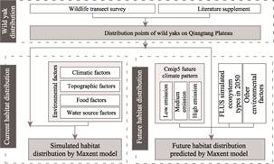
Figure 1 Technical roadmap of the
dataset development
3.3 Simulation of
Current Habitat Distribution
During
the simulation of wild yaks?? habitat distribution, the presence points of wild
yaks acquired from field measurements served as training and testing samples.
The Maxent model, a powerful tool in ecological research renowned for its
ability to predict species distributions, was utilized to simulate the habitat
distribution. This model has been extensively applied in wildlife conservation
studies, leveraging the actual presence-point data of species in conjunction
with relevant environmental variables to estimate habitat distributions[14].
Specifically, the Maxent model identifies the solution with the maximum entropy
value among a set of model solutions that satisfy specific constraints, which
is then employed as the predicted species distribution[15].
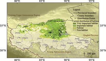
Figure 2 Map of distribution places
of wild yaks (2019–2022)
Accounting for
the physiological traits of wild yaks and their habitat-selection preferences,
four categories of environmental factors directly influencing wild yaks??
distribution were selected: climate, topography, food, and water sources. To
mitigate collinearity issues and prevent model over-fitting, a comprehensive
correlation analysis was conducted on all potential environmental variables.
Variables with high correlations and weak associations with wild yaks??
habitat-selection preferences were eliminated. In the end, 16 indicators were
retained (Table 2). Subsequently, the wild yaks?? point data and the
four-category environmental factor data were incorporated into the Maxent
model. To assess the model??s accuracy, 20% of the wild yaks?? distribution points
were randomly selected. Through model computations, the distribution
probability values of wild yaks within the study area were derived, enabling
the classification of habitat distributions. Areas with a distribution
probability exceeding 0.15 were classified as ??Potential habitats??, while those
with lower probabilities were designated as ??Non-habitats??. Specifically, areas
with a probability higher than 0.6 were identified as ??Very important habitats??
for wild yaks, those with a probability between 0.25 and 0.6 were considered
??Important habitats??, and the remaining areas were classified as ??Habitats??[9,13,15].
3.4 Prediction of Future
Habitat Distribution
This
study integrated future climate data and ecosystem-type data predicted by
Geo-FLUS to construct the environmental scenarios of the Qiangtang Plateau in
2050, considering four aspects: future climate, topography, food, and water
sources (Table 2). Leveraging the current distribution points of wild yaks, the
Maxent model was applied to forecast their future habitats. To ensure
consistency in habitat classification, the threshold used for classifying
current habitats was adopted for the simulation results.
The future climate data for the Qiangtang
Plateau were sourced from three Representative Concentration Pathways (RCPs)
scenarios in 2050 provided by the CMIP5[16]:
RCP2.6, RCP4.5, and RCP8.5. The future ecosystem-type data were
predicted using the Geo-FLUS model. The Geo-FLUS model, based on the Cellular
Automata (CA) principle, utilizes the Artificial Neural Network (ANN) algorithm
to establish relationships between land use, human activities, and natural
factors, thereby simulating and predicting future ecosystem types[9].
The environmental factors incorporated in the simulation included average
temperature, annual average precipitation, distance from water bodies,
altitude, slope, etc., while human-related factors encompassed population
density, GDP, and distance from highways. The historical ecosystem-type data
consisted of MODIS-MCD12Q1 ecosystem-type data from 2001, 2010, and 2019, which
were employed to evaluate the model??s accuracy. First, the 2001 ecosystem-type
data were used to simulate the 2010
Table 2 Data sources of the input
parameters of the models
|
Data type
|
Data name
|
Data source
|
Models
|
|
Maxent
|
FLUS
|
|
Wild yaks
|
Points of wild
yaks?? distribution
|
Results of
line-transect surveys
|
??
|
|
|
Climate
|
Annual mean temperature
(??)
|
From WorldClim1.4 (www.worldclim.org/), ??Historical Dataset?? and
??Future Dataset??
|
??
|
??
|
|
Mean diurnal range
(??)
|
??
|
|
|
Max temperature
of the warmest month (??)
|
??
|
|
|
Min temperature
of the coldest month (??)
|
??
|
|
|
Mean temperature
of the warmest quarter (??)
|
??
|
|
|
Mean temperature
of the coldest quarter (??)
|
??
|
|
|
Annual
precipitation (mm)
|
??
|
??
|
|
Precipitation of
the wettest month (mm)
|
??
|
|
|
Precipitation of
the driest month (mm)
|
??
|
|
|
Precipitation of
the warmest quarter (mm)
|
??
|
|
|
Precipitation of
the coldest quarter (mm)
|
??
|
|
|
Topography
|
Slope (??)
|
ASTER_GDEM (earthdata.nasa.gov/)
|
??
|
??
|
|
Altitude (m)
|
??
|
??
|
|
|
Net Primary
Production (NPP)
|
The current
situation data comes from the Resources
and Environment Science Data Center (www.resdc.cn/), and the future
data comes from the reference[16]
|
??
|
|
|
Land cover types
(2001, 2010, 2020)
|
MODIS_MCD12Q1
(earthdata.nasa.gov/)
|
??
|
??
|
|
Water source
|
Distance from
water source (km)
|
Resources and
Environment Science Data Center (www.resdc.cn/)
|
??
|
??
|
|
Forage
|
Population
density (104 person/km2)
|
|
??
|
|
Gross Domestic
Product (GDP) (108 CNY)
|
|
??
|
|
Distance to
roads (km)
|
|
??
|
scenario, and the results were compared with the
actual 2010 data, yielding a Kappa coefficient of 0.839 and an overall accuracy
of 0.913. Subsequently, the 2010 ecosystem-type data were used to simulate the
2019 scenario, and the comparison with the actual 2019 data resulted in a Kappa
coefficient of 0.907 and an overall accuracy of 0.949. Given its satisfactory
accuracy, the Geo-FLUS model was deemed suitable for future land-use scenario
simulations. Based on the 2019 ecosystem-type data, the climate factors were
substituted with the CMIP5 2050 climate-scenario data to simulate the future
ecosystem types of the Qiangtang Plateau, and the ecosystem-type results under
the three greenhouse-gas-emission models were obtained[16,17].
4 Data Results and Validation
4.1 Dataset Composition
This dataset consists of 3 parts: (1)
distribution point data of wild yaks; (2) current distribution data of wild
yaks?? habitats; (3) predicted distribution data of wild yaks?? habitats in 2050.
The dataset is archived in .tif, .shp, and .txt formats and consists of 35 data
files, with a data size of 9.55 MB (compressed into 1 file of 376 KB).
4.2 Data Products
4.2.1 Distribution Results of Wild Yak Transect Surveys
Wild
yaks are frequently observed in the northern part of the Qiangtang Plateau,
including the central-northern part of Shuanghu County in Nagqu City, the
northern part of Nyima County, the northern part of Amdo County, the northern
part of Gerze County in Ngari Prefecture, and Rutog County. These areas are
remote alpine hills with few human settlements. Transect surveys have
identified that Cuozhe Qiangma Township and Gacuo Township in Shuanghu County,
as well as Ejiu Township and Rongma Township in Nyima County, are regions where
wild yaks are relatively concentrated. The largest population size detected
during the surveys was only 4 individuals. The detected presence points are
often far from human activities and are generally not disturbed by activities
such as transportation, tourism, and grazing.
The altitude range
of the wild yaks?? presence points is 4,792–5,620 m, with an average altitude of
approximately 5,000 m. Wild yaks prefer to inhabit slopes, and the maximum
slope degree of the presence points is 12??. The average annual temperature is
–6.4 ??, and
the average annual precipitation is around 178 mm. In the driest areas, the
average annual precipitation is only 35 mm. The main vegetation types include
sparse vegetation of Saussurea tridactyla and Waldheimia glabra, alpine steppe
of Stipa purpurea and Carex montis-everestii, with an average vegetation
coverage rate of 19%.
4.2.2 Distribution Results of Current Wild Yak Habitats
The
total area of wild yaks?? habitats on the Qiangtang Plateau is 251,000 km2,
accounting for approximately one-third of the study area. Among them, the area
of very important habitats for wild yaks is 58,000 km2, accounting
for about 7.5% of the Qiangtang Plateau. The area of important habitats is
122,000 km2, and the area of general habitats is 71,000 km2.
The critically important areas for wild yaks are concentrated in the
northeastern part of the Qiangtang Plateau, centered around Duogecuo Lake and
its nearby water systems in the northern part of Nagqu City, spreading
outwards. In addition, there are also some very important habitats distributed
in Rutog County of Ngari Prefecture. The habitats of wild yaks are mainly
concentrated in Nagqu City. The habitat area in Shuanghu County reaches 105,000
km2, accounting for 90% of the total area of Shuanghu County. In
Ngari Prefecture, the habitats are relatively concentrated in the northeastern
part of Gerze County, and there are scattered habitats in Rutog County, Geji
County, and Gar County.
4.2.3 Distribution Results of Future Wild Yak Habitats
Over
the next three decades, the habitats of wild yaks will undergo significant
changes, showing a clear trend of expansion towards the west. It is predicted
that by 2050, a large number of new wild yak habitats will emerge in Gerze
County and Rutog County of Ngari Prefecture. These habitats will still be
characterized by high altitude and remoteness from populated areas. In the
future, the geographical overlap between the distribution boundaries of wild
yaks?? habitats and the Qiangtang Nature Reserve will further increase. Under
the 3 future climate scenarios, the total habitat area will generally increase
by about 33,000 km2. The total areas are 282,000 km2
under the RCP2.6 scenario, 284,000 km2 under the RCP4.5 scenario,
and 280,000 km2 under the RCP8.5 scenario. The location of the core
area remains basically unchanged, and most of the new habitats are important
and general habitats for wild yaks (Figure 3).
Under the three
climate scenarios, the total habitat areas of wild yaks are similar, and the
distribution patterns are alike, with a northward aggregation, especially in
the northwest of the Qiangtang Plateau, where the trend of habitat expansion is
obvious. However, the patterns of scattered habitats in the south vary greatly.
For example, there are a large number of small-scale wild yak habitats in the
southern regions of RCP2.6 and RCP4.5, while in the RCP8.5 scenario, there are
hardly any large-scale habitats in the south. Under the RCP4.5 scenario, the
total area of habitats on the Qiangtang Plateau will increase to 284,000 km2
in the future, with 44,000 km2 of very important habitats, 143,000
km2 of important habitats, and 97,000 km2 of general
habitats.
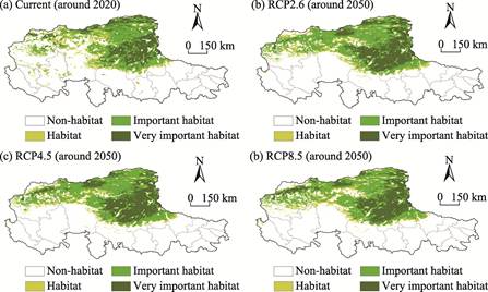
Figure 3 Future distribution maps of
the wild yaks habitats in different scenarios (2050)
4.3 Data Validation
When using the Maxent model
to simulate the current and future habitats of wild yaks, 20% of all the points
were randomly selected to calculate the area under the receiver operating
characteristic curve (i.e., the AUC value) corresponding to the distribution
probability p for accurate
verification. The AUC value of the current habitat simulation results was
0.907. For future habitat simulations, the AUC values were 0.908 under the
RCP2.6 scenario, 0.907 under the RCP4.5 scenario, and 0.904 under the RCP8.5 scenario.
The accuracy of these four simulation results was relatively high, indicating
reliable outcomes.
5 Discussion and Conclusion
This study selected the
Qiangtang Plateau as the study area and adopted a method combining field
surveys and species distribution models. Through four consecutive years of
conducting transect surveys of wild animals, distribution data of the wild yak
population were obtained. Based on an understanding of the physiological
characteristics of wild yaks and their habitat selection preferences, and by
using the field-measured wild yak point data, the Maxent model was employed to
simulate the current habitat distribution of wild yaks. Meanwhile, considering
the changes in future climate conditions and the evolution scenarios of
ecosystem types, the model was further utilized to predict the habitat
distribution of wild yaks in 2050 and analyze the changing trends. It was found
that the research results had a high degree of consistency with previous
written records and image materials of related species.
The study revealed that wild yaks tend to inhabit the
sparsely-populated alpine hilly areas. In terms of geographical distribution,
their habitats are concentrated in the hinterland of the Qiangtang Nature
Reserve, including the central-northern part of Shuanghu County, the northern
part of Nyima County, the northern part of Amdo County, as well as the northern
part of Gerze County and Rutog County in Ngari Prefecture. Statistics show that
the total area of their habitats is 229,000 km2, with Duogecuo Lake in
the northern part of Nagqu City and its nearby water systems as the core area,
spreading outwards in a radial pattern. By 2050, the Qiangtang Plateau will
experience a significant warming and humidification trend. The areas of
ecosystems such as grasslands and water bodies will increase, and the habitats
of wild yaks will expand to the west and north, with an area increase of
approximately 33,000 km2. A large-scale habitat will emerge in the
northern part of Ngari Prefecture, while the scattered habitats in the southern
part will disappear.
The habitats of wild yaks are mostly located in alpine
steppe deserts, alpine sparse- vegetation areas, and gentle slopes of glaciers
and snow-covered areas. Currently, their habitat range is limited, and their
survival status is worrying. According to the results of this study, the
habitats of wild yaks are expected to expand significantly by 2050. However,
the Maxent model used in this study has certain limitations. This model
analyzes the environmental requirements of species for habitats based on the relationship
between the presence points of wild animals and environmental factors and takes
into account factors such as population density and migration barriers.
However, due to the extreme complexity of the actual ecological environment,
many difficult-to-quantify factors cannot be fully covered, resulting in
inevitable uncertainties in model predictions. Due to research limitations,
in-depth studies on the population size, male-to-female ratio, age composition,
and breeding status of wild yaks have not been conducted. Although the
population of wild yaks has shown a restorative increase in the past 20 years,
if the population cannot maintain its growth in the future, it will be
difficult for the habitats to expand as expected.
References
[1]
IUCN. The IUCN red list of
threatened species [R]. International Union for Conservation of Nature and
Natural Resources, 2016.
[2]
Liang, X. C., Kang, A. L.,
Pettorelli, N. Understanding habitat selection of the vulnerable wild
yak Bos mutus on
the Tibetan Plateau [J]. Oryx, 2017,
51(2): 361–369.
[3]
Xu,
Z. R., Jin, M. M., Zheng, X., et al.
Causes for human-wildlife conflict on Changtang Plateau in Xizang [J]. Journal of Natural
Resources, 2019, 34(7): 1521–1530.
[4]
Xu, Z. R., Zou, X. P.
Evaluation of social-ecological effectiveness of protectedd areas on the
Changtang plateau [J]. Acta Ecologica
Sinica, 2020, 40(23): 8743–8752.
[5]
Berger, J., Schaller, G. B., Cheng,
E., et al. Legacies
of past exploitation and climate affect mammalian
sexes differently on
the roof of the world—the case of wild yaks [J]. Scientific Reports, 2015, 5: 8676.
[6]
Buzzard, P. J., Zhang, H.
B., Xu, D. H. et al. A
globally important wild yak Bos
mutus population in the Arjinshan Nature Reserve, Xinjiang, China [J].
Oryx, 2010, 44(4): 577–580.
[7]
Schaller, G. B., Liu, W. L.
Distribution, status, and conservation of wild yak Bos grunniens [J]. Biological Conservation, 1996, 76(1):
1–8.
[8]
Xu, Z. R., Wei,
Z. Q., Jin, M. M. Causes of domestic livestock: wild herbivore
conflicts in the alpine ecosystem of the Chang Tang Plateau
[J]. Environmental Development, 2020,
34: 100495.
[9]
Liu, X. P., Liang, X., Li, X., et
al. A future land use simulation model (FLUS) for simulating multiple land
use scenarios by coupling human and natural effects [J]. Landscape and Urban Planning, 2017, 168: 94–116.
[10]
Liu, W. L., Schaller, G. B.
Distribution and current situation of wild yaks [J]. Tibet Science and Technology, 2003, 11: 17–23.
[11]
Wei, Z. Q., Xu, Z. R., Wei, X.
W., et al. Distribution dataset of
wild yaks on Qiangtang Plateau and current
(2019–2022)/future scenarios of submerged habitats [J/DB/OL]. Digital Journal of Global Change Data Repository, 2024.
https://doi.org/10.3974/geodb.2024.12.09.V1.
[12]
GCdataPR Editorial Office.
GCdataPR data sharing policy [OL]. https://doi.org/10.3974/dp.policy.2014.05
(Updated 2017).
[13]
Wildlife Conservation Society
(WCS). Report on ungulate status and trends in the Tibetan plateau [R]. New
York: The Wildlife Conservation Society, 2014.
[14]
Merow, C., Smith, M.
J., Silander, J. A. A practical guide to MaxEnt for modeling species??
distributions: what it does, and why inputs and settings matter [J]. Ecography, 2013, 36(10): 1058–1069.
[15]
Wei, Z. Q., Xu, Z. R. Habitat
distribution of Tibetan antelope in the Chang Tang plateau and influential
factors [J]. Acta Ecologica Sinica,
2020, 40(23): 8763–8772.
[16]
Zheng, Z. T. Simulated global
ecosystem productivity under different CO2 concentration scenarios
during 2006–2100 [DB/OL]. National Tibetan Plateau/Third Pole Environment Data
Center, 2022. https://data.tpdc.ac.cn/home.
[17]
Wei,
Z. Q., Xu, Z. R., Qiao, T., et al.
Habitats change of Tibetan Antelope and its influencing factors on the North
Tibetan Plateau from 2020 to 2050 [J]. Global
Ecology and Conservation, 2022(43): e02462.