Habitat Assessment Dataset Covering the Upper Reaches of Min River of China
Guo, Y. L. Wang, Q.* Yan, W. P. Zhou, Q. Shi, M. Q.
School of Environment and Resource, Southwest University of Science and Technology, Mianyang 621010, China
Abstract: Habitat suitability is one of the most important criteria for assessing the status of regional eco-environments. The assessment of the suitability of plant habitats can reveal the quality of regional habitats, and provide basic data to support climate change research and sustainable development plans for settlement in mountainous areas. Using the ArcGIS software and based on ASTER GDEM data, and in situ field survey data, the Habitat Assessment Dataset cover the Upper Reaches of Min River of China was developed. The data products indicate: (1) Suitable and sub-suitable habitats habitat area covers 4,431.80 km2 and 6,171.12 km2, respectively, accounting for 47.35 % of the whole area. The results indicated that the plant habitat in the Upper Reaches of the Min River was poor and that ecological restoration was both urgent and difficult. (2) Significant spatial differentiation characteristics of habitat suitability were discovered in URMR. Suitable and sub-suitable habitats were mainly distributed in the upper parts of the V-shaped valley in the arid valley, where the vegetation types were mainly evergreen trees, deciduous broad-leaved mixed forests and coniferous broad-leaved mixed forests. In these areas, habitat restoration would be easier and would have better results. Unsuitable habitat was mainly distributed in high altitude areas, where the vegetation types were mostly alpine shrubs and meadows. In the bottom of the arid valley, the levels of habitat suitability were assessed as being unsuitable and most unsuitable; here, the vegetation types were mainly arid shrubs and ecological restoration was difficult. The dataset is archived in .tif data format with a data size of 4.57 MB.
Keywords: habitat; suitability; spatial pattern; the Upper Reaches of the Min River
1 Introduction
A habitat is an ecological or environmental area that is inhabited by a particular species of animal, plant, or other type of organism (https://en.wikipedia.org/wiki/Habitat). It comprises unique states of different environmental factors, and are comprised of essential living conditions and biological and abiotic factors. Suitable vegetation habitats provide important material conditions for the existence and development of human settlements, and are also an important indicator when assessing the sustainability of human-land systems.
The area covering the Upper Reaches of the Min River (URMR) is a unique eco-zone in the mountain areas of Southwest China. It is located in the transition zone between the edge of the Sichuan Basin and the Tibetan Plateau (30°45′31″N-33°09′21″N, 102°35′20″E-103° 56′57″E)[1]. It demonstrates typical characteristics of an ecologically fragile area[2−3], such as a high risk of ecological degradation, a low ecological safety threshold and multi-ethnic settlement symbiosis. The area plays an important role in national ecological security strategy, specifically, “the Two-Shelter and Three-Belt Project”. The assessment of the suitability of plant habitats in URMR will reveal the status and spatial distribution of habitat quality in mountainous areas and will provide basic data support for research concerning regional response to climate change and the sustainable development plans for mountains settlements against a background of environmental change. Based on ASTER GDEM data, existing research results and field survey data, the assessment dataset of habitat suitability in the Upper Reaches of the Min River was developed, which covered 5 aspects: terrain; meteorological condition; soil type; vegetation type; and habitat suitability[4].
2 Metadata of Dataset
The metadata of assessment dataset of habitat suitability in the Upper Reaches of the Min River (China) is summarized in Table 1. It includes the dataset full name, short name, authors, year of the dataset, temporal resolution, spatial resolution, data format, data size, data files, data publisher, and data sharing policy, etc.
Table 1 Metadata summary of assessment dataset of habitat suitability
in the Upper Reaches of the Min River, China
|
Items
|
Description
|
|
Dataset full name
|
Assessment dataset of habitat suitability in the Upper Reaches of the Min River, China.
|
|
Dataset short name
|
AsseDataHabitatMinRiverBasin
|
|
Authors
|
Guo, Y. L. L-5221-2016, guoyalin_linda@163.com
Wang, Q. L-5245-2016, qingw@imde.ac.cn
Yan, W. P. L-5250-2016, yanchong6868@163.com
Zhou, Q. L-5248-2016, sad08.love@163.com
Shi, M. Q. L-5595-2016, minqiushi@126.com
|
School of Environment and Resource, Southwest University of Science and Technology,
|
|
Geographical region
|
The geographical region covers 30°45′31″N-33°09′21″N and 102°35′20″E-103°56′57″E, mainly includes the arid valley in Wenchuan County, Li County, Mao County, Heishui County and Songpan County in Ngawa Tibetan and Qiang Autonomous Prefecture, Sichuan Province, China. Dujiangyan is discarded due to data scarcity
|
|
Year
|
1981-2000
|
|
Spatial resolution
|
60 m, 300 m
|
|
Data format
|
.tif
|
Data size 4.57 MB (in .rar file)
|
|
Data files
|
The major parts of the dataset are as follows: (1) Terrain data, including elevation cluster, slope cluster and aspect data; (2) Meteorological data, including the average temperature, sunshine duration, evaporation and relative humidity in Dry Season and Wet Season and the annual rainfall; (3) Spatial data of soil types; (4) Spatial data of vegetation types; (5) Data relating to habitat suitability values and habitat suitability levels
|
| |
|
|
|
(To be continued on the next page)
(Continued)
|
Items
|
Description
|
|
Foundation(s)
|
Ministry of Science and Technology of P. R. China (2011BAK12B04-02); National Natural Science Foundation of China (41071115)
|
|
Data publisher
|
Global Change Research Data Publishing & Repository, http://www.geodoi.ac.cn
|
|
Address
|
No. 11A, Datun Road, Chaoyang District, Beijing 100101, China
|
|
Data sharing
policy
|
Data from the Global Change Research Data Publishing & Repository includes metadata, datasets (data products), and publications (in this case, in the Journal of Global Change Data & Discovery). Data sharing policy includes: (1) Data are openly available and can be free downloaded via the Internet; (2) End users are encouraged to use Data subject to citation; (3) Users, who are by definition also value-added service providers, are welcome to redistribute Data subject to written permission from the GCdataPR Editorial Office and the issuance of a Data redistribution license; and (4) If Data are used to compile new datasets, the ‘ten per cent principal’ should be followed such that Data records utilized should not surpass 10% of the new dataset contents, while sources should be clearly noted in suitable places in the new dataset[5]
|
3 Methods
3.1 Data Sources
The following data were used for the dataset development, they are: ASTER GDEM data jointly developed by METI in Japan and NASA[6], thematic atlas from the Eco-Hydrological Atlas of the Minjiang Upstream[7]; the Vegetation Atlas of China (1??1,000,000) [8]; and the Theory and Practice of Ecological Construction in the Upper Reaches of Minjiang River[9].
3.2 Data Processing
(1) Land slope data were developed based on the DEM[10],
(2) In order to get the digital thematic map data, the boundary of URMR was used as the reference data. Spatial registration and image vectorization of the scanned maps of the thematic atlas maps were carried out under WGS_1984_UTM_Zone_48N coordinate system with 300 m resolution.
(3) Development of habitat data: the assessment index system was built with 3 first-level indexes (terrain; soil; and meteorological conditions) and 13 secondary indexes (elevation; slope; aspect; soil stability; annual rainfall; sunshine duration in Dry Season and Wet Season; average temperature in Dry Season and Wet Season; evaporation in Dry Season and Wet Season; and relative humidity in Dry Season and Wet Season).The evaluation criteria used for the assessment of habitat suitability were developed using the grade assignment method, based on the actual spatial distribution of natural habitat indexes, existing literatures and expert suggestions[11].
Based on the evaluation criteria, a suitability assessment for single habitat element in the basin was carried out. The Analytic Hierarchy Process (AHP) and entropy method were used to calculate weights of indexes. The habitat suitability value was calculated based on a spatial analysis of the suitability grade data of all the habitat factors by using a multi-objective linear weighting model (equation (1). Natural Breaks (Jenks) method in ArcGIS was selected for the classification of habitat suitability values (Table 2).
 (1)
(1)
Where, S is the comprehensive evaluation value of the habitat suitability; Wi is the weight of the ith evaluation index; Si is the score of the ith index; n is the number of evaluation indexes.
Table 2 Evaluation criteria of habitat suitability in the Upper Reaches of the Min River[11]
|
Suitability Value
|
Suitability
|
Practical meaning
|
|
3.951-2.830
|
Suitable
|
The areas at this level are located at an altitude of 2,100 to 2,800 m or less than 1,300 m and have better suitability, with better meteorological conditions and soil stability that make better growth conditions for vegetation, whose main vegetation types are evergreen and deciduous broad-leaved mixed forests
|
|
2.830-2.362
|
Sub-suitable
|
The areas at this level have good suitability, located at an altitude of 2,800 to 3,600 m, with good meteorological conditions and soil stability that make good growth conditions for vegetation, whose main vegetation types are coniferous and broadleaved mixed forests
|
|
2.362-1.894
|
Unsuitable
|
The areas at this level have lower suitability, located at an altitude of 1,300 to 2,100 m, with poorer weather conditions and soil stability that make poorer growth conditions for vegetation, whose main vegetation types are shrubs
|
|
1.894-1.165
|
Most
Unsuitable
|
The areas at this level have worst suitability, located at an altitude of greater than 3,600 m, with worst weather conditions and soil stability that make worst growth conditions for vegetation, whose main vegetation types are meadows or bare lands
|
4 Results and Validation
4.1 Data Products
The assessment dataset of habitat suitability in URMR consisted of 5 parts: (1) Terrain data (Figure 1), including elevation data, slope data, aspect data; (2) Meteorological data, including the average temperature, sunshine duration, evaporation and relative humidity in Dry Season and Wet Season and the annual rainfall; (3) Distribution data of vegetation communities with 45 vegetation types in 7 vegetation groups (Figure 2a); (4) Distribution data of soil types (Figure 2b); (5) Data relating to habitat suitability values and habitat suitability levels (Figure 3).
4.2 Statistics
Analysis results showed that:
(1) On the whole, the habitat suitability of URMR was poor.
The suitable and sub-suitable habitats accounted for 47.35% of the whole area and the area of suitable habitat was the least. The unsuitable habitat area accounted for 29.83 % of the whole area, and was distributed in higher elevation areas and the arid valley. The least suitable habitat area covered an area of 5,107.23 km2 (22.81%) (Table 3).
(2) The habitat suitability of URMR has significant spatial differentiation characteristics.
In the suitable and sub-suitable habitats distributed in the upper parts of the V-shaped valley in the arid valley, the vegetation types were mainly evergreen trees, deciduous broad-leaved mixed forests and coniferous broad-leaved mixed forests.
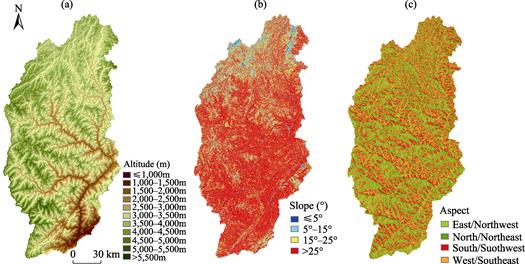
Figure 1 Data maps of elevation cluster, slope cluster and aspect in the Upper Reaches of the Min River[11]
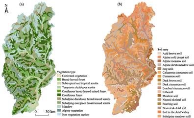
Figure 2 Data maps of vegetation and soil types in the upper reaches of the Min River, China[11]
The comprehensive conditions of ecological factors were found to be suitable. Ecological restoration in these regions would be relatively easy and would achieve good results. The areas of unsuitable habitat were distributed in high altitude areas, and the vegetation types were mostly alpine shrubs and meadows. These two conditions were not conducive to ecological restoration. In the arid valley and drought areas, the habitat suitability values were low and the levels of habitat suitability were assessed as unsuitable and most unsuitable. The vegetation types here were mainly arid shrubs and the ecological restoration was very difficult. The analysis paper was published in Journal of Mountain Science[11], 2015, Vol.12.
4.3 Data Validation
Data validation by overlaying analysis between the habitat suitability map (Figure 3b) and the vegetation map (Figure 2a). The agreement between them is about 90%.
|
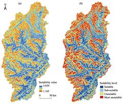
Figure 3 Data maps of the habitat suitability in the Upper Reaches of the Min River[11]
|
5 Discussion
The assessment dataset of habitat suitability in the Upper Reaches of the Min River (URMR) is a macroscopic description of regional habitat characteristics. Based on the combination of the dataset and the micro-scale evaluation of habitat elements, researches considering natural succession and human activity can provide more detailed decision-making references for regional ecological construction and sustainable development planning.
|
Table 3 Statistics of habitat suitability in the Upper Reaches of the Min River
|
Habitat suitability
|
Area (km2)
|
Percentage (%)
|
|
Suitable
|
4,431.80
|
19.79
|
|
Sub-suitable
|
6,171.12
|
27.56
|
|
Unsuitable
|
6,679.76
|
29.83
|
|
Most Unsuitable
|
5,107.23
|
22.81
|
|
Total
|
22,389.91
|
100.00
|
Author Contributions
Wang, Q. designed the algorithms. Guo, Y. L., Yan, W. P., Zhou, Q. and Shi, M. Q. finished the data processing and analysis work. Guo, Y. L. and Wang, Q. wrote the data paper.
References
[1] Wang, Q., Guo, Y. L. Boundary data of the Upper Reaches of Min River Basin, China [DB/OL]. Global Change Research Data Publishing & Repository, 2016. DOI:10.3974/geodb.2016.05.01.V1.
[2] Zhang, R. Z. The Dry Valleys of the Hengduan Mountains Region [M]. Beijing: Science Press, 1992: 1-19.
[3] Wang, Q., Shi, M. Q., Guo, Y. L., et al. The vertical differentiation of the mountain settlement niche in the Upper Reaches of Minjiang River [J]. Acta Geographica Sinica, 2013, 68(11): 1559-1567.
[4] Guo, Y. L., Wang, Q., Yan W. P., et al. Assessment dataset of habitat suitability in the Upper Reaches of Min River, China [DB/OL]. Global Change Research Data Publishing & Repository, 2016. DOI:10.3974/geodb.2016.04.03.V1.
[5] GCdataPR Editorial Office. GCdataPR Data Sharing Policy [OL]. DOI: 10.3974/dp.policy.2014.05 (Updated 2017).
[6] ASTER GDEM. http://reverb.echo.nasa.gov/reverb/.
[7] Liu, S. R., Sun, P. S., Luo, C. W. Eco-hydrological Atlas of the Minjiang Upstream [M]. Beijing: Sino Maps Press, 2008, 20-84.
[8] Editorial Board of Vegetation Map of China, Chinese Academy of Sciences. Vegetation Atlas of China [M]. Beijing: Science Press, 2001: 65-68, 97-100.
[9] Chen, G. J., Tu, J. J., Fan, H., et al. Theory and Practice of Ecological Construction in the Upper Reaches of Minjiang River [M]. Chongqing: Southwest China Normal University Press, 2006: 335-344.
[10] Tang, G. A., Yang, X. ArcGIS Experimental Tutorial on Spatial Analysis of Geographic Information Systems [M]. Beijing: Science Press, 2006, 248-307.
[11] Guo, Y. L., Wang, Q., Yan, W. P., et al. Assessment of habitat suitability in the upper reaches of the Min River in China [J]. Journal of Mountain Science, 2015, 12(3): 737-746.