Comparison of Boundary
Datasets Covering Tibetan Plateau between 2021 and 2014 Versions
Zhang, Y. L.1,2,3* Liu, L. S.1 Li, B. Y.1 Zheng, D.1
1. Key Laboratory of Land Surface
Pattern and Simulation, Institute of Geographic Sciences and Natural Resources
Research, Chinese Academy of Sciences, Beijing 100101, China;
2. Center for Excellence in Tibetan Plateau Earth Sciences,
Chinese Academy of Sciences, Beijing 100101, China;
3.
College of Resources and Environment, University of Chinese Academy of Sciences,
Beijing 100049, China
Abstract: The updated version
of the Datasets of the boundary and region of Tibetan Plateau 2021 was published
in July 2021, which is the updated version of the Datasets of the boundary and
area of the Tibetan Plateau that was published in June 2014. The main
differences between the two versions are as follows: (1) Accuracy of the basic
data used for 2021 boundary data has been improved, which is mainly based on
the comprehensive analysis of high-resolution satellite remote sensing images
and DEM (digital elevation
modeling) data. (2) Geographical boundaries of the Tibetan Plateau have been
extended from the 2014 version??s restriction to China to a complete physical
geographical unit at home and abroad, for which the main extensions include the
southern slopes of the Himalaya, the Hindu Kush, and the Pamir Plateau. The
administrative area now covers 9 countries, namely China, India, Pakistan,
Tajikistan, Afghanistan, Nepal, Bhutan, Myanmar and Kyrgyzstan. The plateau
area is now 308.34??104
km2, an increase of 54.11??104
km2 over the 2014 edition.
(3) This dataset brings in attribute data for each section of the plateau
boundary and data on characteristics of the highlands in areas adjacent to the
plateau, the low basins within the plateau, and the lowlands of the marginal
valleys obtained during the process of determining the plateau??s range. The
dataset of the 2021 version is archived in .shp and .kmz data formats and
consists of 44 data files with data size of 1.07 MB.
Keywords: Tibetan Plateau; boundary; version 2021; vector data; area and boundary
length; attribute characteristics
DOI: https://doi.org/10.3974/geodp.2021.03.10
CSTR: https://cstr.escience.org.cn/CSTR:20146.14.2021.03.10
Dataset Availability Statement:
The dataset supporting
this paper was published and is accessible through the Digital Journal of
Global Change Data Repository at: https://doi.org/10.3974/geodb.2021.07.10.V1 or
https://cstr.escience.org.cn/CSTR:20146.11.2021.07.10.V1.
1 Introduction
The formation and
evolution of the Tibetan Plateau has a great impact on the natural environment
and human survival and development in its surrounding areas[1?C3],
making it a research hot spot in geosciences and biology[1?C7]. The boundary of the plateau is the initial
basis for understanding the Tibetan Plateau. However, limited by a variety of
factors, such as accumulated knowledge and technological development, scholars
have differed greatly in their understanding and recognition of the Tibetan
Plateau?? boundary[7?C9]. Li et al. discussed the extent of the
Tibetan Plateau in 1987 and 2002[8,9]. Based on the 1:1 million landform sketch map and
the 1:3 million landform map of the Tibetan Plateau and its surrounding areas,
with topographic maps and satellite image interpretation analysis as the main
basis, the 1:3 million scale boundary vector delineation and estimation of the
plateau area within China was completed in 2002[9]. The
corresponding GIS dataset was published in 2014[10,11]. With the second comprehensive scientific expedition of
the Tibetan Plateau, the in-depth research on the resources, environment, and
ecology of the plateau, combined with the
accelerating construction of an ecological civilization on the plateau have
jointly exerted new demands on the
boundary determination of the Tibetan Plateau. The authors of the present
dataset further clarify
the principles and basis for determining the extent of the Tibetan Plateau,
based on their understanding and knowledge of its physical and geographical
units. Using recent research results and high-resolution
remote sensing imagery and 30-m DEM data, the 2021 version of the vector data
for the Tibetan Plateau?? boundary was defined using ArcMap software. The specific research concerning the
plateau range was published in Geographical Research[12].
2 Metadata of
the Dataset
The metadata
of the Boundary data of the Tibetan Plateau (2021 Version)[13] is summarized in Table 1. It includes the dataset full
name, short name, authors, year of the
Table 1 Metadata summary of the Boundary data of
the Tibetan Plateau (2021 Version) [13]
|
Items
|
Description
|
|
Dataset full name
|
Boundary data of the Tibetan
Plateau (2021 Version)
|
|
Dataset
short name
|
DBATP2.0
|
|
Authors
|
Zhang, Y.
L., Institute of Geographic Sciences and Natural Resources Research (IGSNRR),
Chinese Academy of Sciences (CAS), zhangyl@igsnrr.ac.cn
Liu, L.
S., IGSNR, CAS, liuls@igsnrr.ac.cn
Li, B. Y.,
IGSNRR, CAS, liby@igsnrr.ac.cn
Zheng, D.,
IGSNRR, CAS, zhengd@igsnrr.ac.cn
|
|
Geographical
area
|
Asia, 25??59??30??N-40??1??0??N, 67??40??37??E-104??40??57??E
|
|
Data
format
|
.kmz,.shp
|
|
|
Data size
|
1.07 MB
|
|
Data files
|
44 files,
such as TPboundary.shp, and compressed into 5 files
|
|
Foundations
|
Second
Tibetan Plateau Scientific Expedition and Research Program (STEP)(2019QZKK0603);
the Strategic Priority Research Program of Chinese Academy of Sciences
(XDA20040201)
|
|
Data
publisher
|
Global Change Research Data Publishing &
Repository, http://www.geodoi.ac.cn
|
|
Address
|
No.
11A, Datun Road, Chaoyang District, Beijing 100101, China
|
|
Data
sharing policy
|
Data from
the Global Change Research Data Publishing & Repository includes metadata, datasets
(in the Digital Journal of Global Change Data Repository), and
publications (in the Journal of Global Change Data & Discovery). Data sharing policy
includes: (1) Data are openly available and can be free downloaded via the
Internet; (2) End users are encouraged to use Data subject to
citation; (3) Users, who are by definition also value-added service
providers, are welcome to redistribute Data subject to written permission
from the GCdataPR Editorial Office and the issuance of a Data redistribution
license; and (4) If Data are used to compile new
datasets, the ??ten per cent principal?? should be followed such that Data
records utilized should not surpass 10% of the new dataset contents, while
sources should be clearly noted in suitable places in the new dataset[14]
|
|
Communication and searchable system
|
DOI, CSTR, Crossref, DCI, CSCD, CNKI, SciEngine, WDS/ISC,
GEOSS
|
dataset, data format, data size, data files, data
publisher, and data sharing policy, etc.
The datasets underpinning the boundary and region of
Tibetan Plateau version-2021
(hereon the ??2021 version??) and the boundary and area
of the Tibetan Plateau released in
2014[9,10] were compared in several ways.
3.1 Geographical Boundary Comparison
Geographical coverage
of the Tibetan Plateau extent dataset 2014 edition is limited to the territory
of China. The 2021 version is based on the integrity of the physical
geographical unit of the Tibetan Plateau, extending from that part within China
to the whole Tibetan Plateau. The Tibetan Plateau (2021 version) starts from
the northern edge of the Pamirs and the northern foothills of the West Kunlun
Mountains?CAltun Mountains?CQilian Mountains to the southern edges of the Hindu
Kush Mountains, the Himalayas, and the Hengduan Mountains; it runs from the
western edge of the Pamirs and Hindu Kush Mountains to the eastern edge of the
Qilian Mountains and Hengduan Mountains.
Overall, it lies within nine countries: China, India, Pakistan, Tajikistan,
Afghanistan, Nepal, Bhutan, Myanmar, and Kyrgyzstan (Figure 1), having a range
corresponding 25??59??30??N-40??1??0??N, 67??40??37??E- 104??40??57??E,
running north?Csouth for about 1,560 km and east?Cwest for about 3,360 km,

Figure 1
Comparison of the 2021 version[12,13] and 2014 version[9?C11]
of the Tibetan Plateau
(Note: Compiled on the
basis of Figure 3 in ref. [12])
and
encompassing a total area of 308.34??104 km2 at an average
altitude of about 4,320 m. Specifically, China harbors 258.13??104 km2
of the plateau, with an average altitude of about 4,400 m, which spans six
provinces and regions??Tibet autonomous region (TAR), Qinghai province, Gansu
province, Sichuan province, Yunnan province and Xinjiang (mainly including TAR
and Qinghai province)??involving 221 county administrative units (151 complete
county administrative units are distributed in the plateau) (The area information of China and its administrative units is
based on the 1:1 million national basic geographic database of the National
Basic Geomatics Center, Ministry of Natural Resources[15].)
The area and boundary
length of the 2021 and 2014 versions of the Tibetan Plateau vary substantially.
When comparing the versions, the most westerly point changes the most, from
73??29??56??E in the 2014 version to 67??40??37??E in the 2021 version, an extension
of 5??49??19??, while the southernmost point is increased by 8?? (Table 2). The total area is
54.11??104 km2 greater in the 2021 than 2014 edition, an
increase of 21.29%. The plateau??s boundary length is now 10,094 km, which is 1,652
km less than in the 2014 version.
Table
2
Comparing the area and boundary length of the Tibetan Plateau in 2021
vs. 2014
|
|
2014 version
|
2021 version
|
D-value
|
Change (%)
|
|
Geographic coordinates
(4 vertices) *
|
East: 104??40??20??E
West: 73??29??56??E
South: 25??59??38??N
North: 39??49??28??N
|
East: 104??40??57??E
West: 67??40??37??E
South: 25??59??30??N
North: 40??1??0??N
|
East: +37??
West: +5??49??19??
South: +8??
North: +10??32??
|
|
|
Area (km2)
|
254.23??104
|
308.34??104
|
+54.11??104
|
21.29 (+)
|
|
Boundary length (km)
|
11,746
|
10,094
|
?C1,652
|
14.06 (?C)
|
*When the 2014 version of
the 4 vertices data was published in 2014, the 2002 version of MapInfo software
format was transferred to ArcInfo software format, there was a slight fine
adjustment.
3.2 Re-using Comparison of Basic Data
The
types of information and their accuracy in the 2021 version data for the
Tibetan Plateau have been greatly improved. The prior 2014 version was based on
the 1:1 million scale topographic maps, while the 2021 version used recent
research papers, other information sources, and map materials, along with
Google Earth??s high resolution remote sensing imagery and DEM data at a spatial
resolution of 30 m. In the 2014 version,
the west section of Motianling in the west of the Daba Mountains on the eastern
boundary of the plateau, which lies at more than 4,000 m above sea level, was
included in the Tibetan Plateau. In the 2021 version of the boundary
delimitation, new data are used to analyze the boundary of that particular
section. This revealed that the northwest?Cwest orientation in the western
section of Motianling and the northeast?Ceast orientation in the mid-eastern
section extend in an arc-like direction. That clearly differs from the
north?Csouth direction of the mountain on the east side of Minshan Mountains.
And the Motianling and Minshan are separated from the valley by the upper
reaches of the Fujiang river. Therefore, the 2021 version assigned the western
part of Motianling to the Daba Mountains instead of the Qinghai-Tibetan Plateau
(Figure 1d). By contrast, the northern mountains in the south of Bailong river
and the northeast of Baishuijiang river (in the east of Nanping county) at an
altitude of about 4,000 m are in a southeast orientation, not unlike the
orientation for Minshan Mountain in the north; hence the former can be regarded
as the southern extension of Minshan Mountain. In the 2021 version, they are
classified together as Hengduan Mountains, which are part of the Tibetan
Plateau (Figure 1d).
The 2021 version is more accurate than the 2014
version in determining the altitude of the Tibetan Plateau and the integrity of
the mountains in the plateau[12]. From a geomorphogenesis perspective, the low
basins and valley lowlands on the edge of the Tibetan Plateau were formed by
local differential movement of the original plateau or river erosion that
occurred during the process of large-scale uplift of the Tibetan Plateau.
Therefore, the low basins in the plateau, sloping ridge-like mountaintops, and
valley lowlands should belong to the Tibetan Plateau. Yet some lowlands on the
plateau??s edge were excluded from the plateau in the 2014 version, generating a
relatively large difference between the two editions of this part of the
boundary data. As depicted in Figure 1b, 1c, and 1e in the 2014 version, the
southern end of Hengduan Mountains has complex terrain, a relatively fuzzy
plateau boundary, a tortuous boundary line, and a relatively long boundary
length. The 2021 version is based on the continuous distribution of the plateau
surface above 4,000 m, for which a unified top surface serves as the main basis
for describing the scope of the Tibetan Plateau. Accordingly, from the
perspective of the plateau??s origin and consideration of its integrity, the
residual planation surface, such as marginal lowlands (Yanyuan Basin), should
also belong to the Tibetan Plateau, with a relatively straight boundary line
and thus a relatively short length.
3.3 Boundary of Tibetan Plateau and Related Geomorphology
In the
2021 version of the Tibetan Plateau range dataset, the attribute data for each
segment of the boundary were added. This supplementation includes data for the
highlands in areas adjacent to the Tibetan Plateau, the low basins in the
plateau, and the main valley lowlands at the boundary (Figure 2). These data
are not found in the 2014 version.
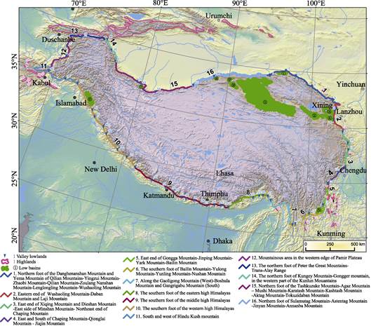
Figure 2 Range and boundary of the Tibetan
Plateau
(Note: Serial numbers for each section
of plateau boundary, highlands in adjacent areas, low-lying basin, and valley
lowland in this figure correspond to those in Table 3?C6, respectively.)
3.3.1 Plateau Range and
Boundary Information of Each Section
The specific boundary and main features of each segment of
the plateau are conveyed in detail in Figure 2 and Table 3. The 2021 dataset
includes the refined boundary line (linear data) and geographical area (area
data). Figure 2 is a reduced version of the boundary vector map of the Tibetan
Plateau at a scale of approximately 1:1,000,000. Through the joint analysis of
Figure 2 and Table 3, the scope of the Tibetan Plateau was thus obtained.
Table 3 Main characteristics of the
boundary of each section of the Tibetan Plateau
|
ID
|
Subsection
|
Description
|
|
1
|
Northern foot of the Danghenanshan Mountain and Yema Mountain of Qilian
Mountains?CYingzui Mountain?CZhaobi Mountain?CQilian Mountain?CZoulang Nanshan
Mountain?CLenglongling Mountain?CWushaoling Mountain
|
Located in Gansu province,
corresponding to the Qaidam Basin desert region and the Qilian Mountains of
the eastern Qinghai high mountain and basin coniferous forest region, from
the Dangjin Mountain Pass to the eastern end of Wushaoling Mountain. It is
bordered by the plateau and mountains of sub-high altitude in the southern
Hexi corridor. It is 1,004 km long with an average altitude of 2,770 m
|
|
2
|
Eastern end of Wushaoling Mountain?CDaban Mountain
and Laji Mountain
|
Located in Gansu and Qinghai
province, corresponding to the Qilian Mountains of the eastern Qinghai high
mountain and basin coniferous forest region. It is roughly on the front line
of Tianzhu (northwest), Minhe, Jishishan (west), and Hezheng (south). It
borders the medium and small undulating sub-high mountains in the west of the
Loess Plateau, with a length of 398 km and an average altitude of more than 2,640
m. The boundary line intersects with the mountain strike vertically, and the
geomorphic difference between the two sides is not obvious
|
|
3
|
East end of Xiqing Mountain and Dieshan Mountain?CEast side of Minshan
Mountain?CNortheast
end of Chaping Mountain
|
Located in Gansu and Sichuan
province, in the eastern part of the north section of Hengduan Mountains,
corresponding to the Western Sichuan and Eastern Xizang high mountain and
basin coniferous forest region, and Qilian Mountains of the eastern Qinghai
high mountain and basin coniferous forest region. It is roughly on the line
spanning Min county (southwest)?CDangchang county (southwest)?CWen county
(west)?CPingwu (west)?CBeichuan (west), bordering Qinling and Daba subalpine
regions, with a length of 492 km and an average altitude of more than 2,170 m
|
|
4
|
East and South of Chaping Mountain?CQionglai Mountain?CJiajin Mountain
|
Located in Sichuan province,
the eastern part of the middle Hengduan Mountains in Sichuan province,
corresponding to the Western Sichuan and Eastern Xizang high mountain and
basin coniferous forest region. It roughly lies near the Guanxian
(west)?CBaoxing (west)?CLuding (east) line, linking up with the low and middle
mountains on the western edge of the Sichuan
Basin. It is 285 km long with an average altitude of more than 2,160 m
|
|
5
|
East end of Gongga Mountain?CJinping Mountain?CYark Mountain?CBailin
Mountain
|
Located in the eastern
mountainous area of the southern section of Hengduan Mountains in Sichuan
province, corresponding to the Western Sichuan and Eastern Xizang high
mountain and basin coniferous forest region and the Yunnan Plateau evergreen
broadleaved forest and pine forest region. It lies roughly near the line of
Luding?CShimian (west)?CMianning (west)?CYanyuan (south). It borders the
southwest subalpine mountain areas of Sichuan province, with a length of 341
km and an average altitude of 2,300 m
|
|
6
|
Southern foot of Bailin Mountain?CYulong Mountain?CYunling
Mountain?CNushan Mountain
|
Located in Yunnan and
Sichuan, corresponding to the Yunnan Plateau evergreen broadleaved forest and
pine forest region. It is roughly in the line of Yanyuan (south)?CNinglang
(south)?CLijiang (north), Jianchuan (north)?C Lushui. It is 430 km long and ca.
2,500 m above sea level. The boundary line intersects with the strike of the
mountains nearly vertically, and the geomorphic difference between the two
sides is not obvious
|
|
7
|
Along the Gaoligong Mountain (West) ?CBoshula Mountain and Gangrigabu
Mountain (South)
|
Located in the southwest of
Hengduan Mountains, except for a small part in Chayu, Tibet autonomous
region, China, and most of the area distributed in the north of Myanmar and
the northeast of India, corresponding to the southern East Himalayas Mountain
seasonal rainforest and evergreen broadleaved forest region. It spans the
east side of Enmeikaijiang River to Danlongqu River; it is about 526 km long
with an average altitude of 2,150 m
|
|
8
|
Southern foot of the eastern high Himalayas
|
Located in Shannan and Linzhi
of the Tibet autonomous region, China, corresponding to the southern East
Himalayas mountain seasonal rainforest and evergreen broadleaved forest
region, spanning roughly from Danlongqu River to Zhongli River near the
border of Bhutan and China, and bordering subalpine mountains at the southern
foot of the high Himalayas. It is 457 km long with an average altitude of
more than 1,850 m
|
(To be continued on the next page)
(Continued)
|
ID
|
Subsection
|
Description
|
|
9
|
Southern foot of the middle high Himalayas
|
Located in Nepal, Bhutan, and
Sikkim (India), corresponding to the evergreen broad-leaved forest region of
the southern flank of the Middle Himalayas, it roughly spans the Zhongli
River to the Karnali River (Peacock River) along the southern foot of the
high Himalayas, bordering the low Himalayas, with a length of 1,123 km and an
average altitude of 1,740 m
|
|
10
|
Southern foot of the western high Himalayas
|
Located in India, Kashmir,
Pakistan, and Nepal, corresponding to the West Himalayan broad-leaved forest
region. It roughly spans from the Karnali River (Kongque River) to the Indus River along the southern foot of the high
Himalayas, bordering the low Himalayan Mountains, with a length of 1,113 km
and an average altitude of 2,050 m
|
|
11
|
South and west of Hindu Kush Mountains
|
Located in Afghanistan and
Pakistan, corresponding to mountainous dark coniferous forest, desert, and
the xerophytic shrub area of eastern Afghanistan. It spans roughly from the
Indus river to the west, along the north side of the Kabul river valley to
the north of Bamian valley, from the northwest of Bamian around the Hindu
Kush mountain, and then along the north side to the east in the vicinity of
Banu. The boundary is bordered by the middle mountain and subalpine mountain
on the edge of the valley. It is 724 km long with an average altitude of 2,360
m
|
|
12
|
Mountainous area
in the western edge of Pamir Plateau
|
Located in Afghanistan and
Tajikistan, corresponding to mountainous woodland and grassland of Central
Asia and the alpine meadow of Hindu Kush. From Banu to the west end of the
Peter the Great Mountains, it is bordered by sub-high mountains at the
western foot of the Pamir Plateau. It is 528 km long with an average altitude
of 2,450 m
|
|
13
|
Northern foot of Peter the Great Mountains?CTrans?CAlay Range
|
Located in Tajikistan,
Kyrgyzstan, and Xinjiang of China, corresponding to Alai open woodland and
the Pamir Alpine desert, lying roughly along the northern foot of the Peter
the Great Mountains and the Trans-Alay Range to the eastern end of the Togoqiaoertao Mountain,
and bordering subtropical mountains at the southern edge of the Kizilsu
valley basin. It is 427 km long with an average altitude of 3,110 m
|
|
14
|
Northern foot of Kungey Mountain?CGongger mountain, in the western part
of the Kunlun Mouantains
|
Located in Xinjiang,
corresponding to the mountainous desert area of the northern flank of the
Kunlun Mountains, spanning the eastern end of Tuoguoqiaoertao Mountain to the
outlet of Yeerqiang River, and bordering the Loess-covered subalpine
mountains in the southwest margin of the Tarim Basin. It is 284 km long with
an average altitude of 2,680 m
|
|
15
|
Northern foot of the Tashkuzuke Mountain?CAgaz Mountain-Mushi
Mountain?CKaratash Mountain?CKashtash Mountain-Aktag Mountain?CTokuzidaban
Mountain
|
Located in Xinjiang,
corresponding to mountainous desert zone, it spans the Yeerqiang River outlet
to the Cheerchen River outlet, bordering the sub-high altitude plain platform
and mountains in the southern margin of the Tarim Basin, having a length of 1,066
km and an average altitude of nearly 3,000 m
|
|
16
|
Northern foot of Sulamutag Mountain?CAstentag Mountain?CJinyan
Mountain?CAnnanba Mountain
|
Located in Xinjiang and
Gansu, corresponding to the desert area of Qaidam Basin, it spans from the
Che??erchen River??s mouth to the Dangjin Mountain pass. It borders the sub-high
and middle altitude plain platform and mountain areas in the Tarim Basin and
the Hexi corridor??s southern margin. It is ca. 854 km long with an average
altitude of 2,620 m
|
3.3.2 Highlands in Adjacent
Areas
Based on the DEM and remote sensing images, this study
analyzed the spatial pattern of large landforms in the Tibetan Plateau and its
adjacent areas, and defined the spatial distribution of the plateau and its
adjacent areas at an altitude of about 4,000 m and above. Except for the
Tibetan Plateau region and Tianshan Mountains, the other 30 highlands at over 4,000
m and their main features are included in the dataset (Table 4). They are
scattered and discontinuous from the surface of the Tibetan Plateau, often
separated by tectonic basins and valleys, and are fault-block mountains outside
the Tibetan Plateau[12]. This also further verifies the feasibility
of the principle of defining the range of the plateau based on its continuous
distribution above 4,000 m and the reliability of the data obtained.
3.3.3 Low Basins in the
Plateau
There
are, however, some low-lying basins on the inner edge of the Tibetan Plateau,
which are 1,000?C2,000 m lower than the plateau. Eleven basins with an altitude
of 1,600?C2,900 m, such as the Qaidam Basin, Gonghe Basin, and Kashmir valley,
were extracted and their characteristics briefly analyzed (Table 5). These low
basins are the relative lowlands formed
Table 4
Highlands in the adjacent areas of the Tibetan Plateau*
|
ID
|
Name
|
Location
|
Description
|
|
1
|
Dahuang
Mountain
|
Zhangye city and Jinchang city of Gansu province; 38.4??N, 101.3??E
|
Located at the junction of
Shandan county and Yongchang county, at an altitude of 3,976 m a.s.l., it has
a nearly east?Cwest orientation and is about 18 km long
|
|
2
|
Baishi Mountain
|
Gannan prefecture and
Dingxi city of Gansu province; 34.9??N, 104??E
|
Located at the junction of
Zhuoni county, Weiyuan county, Zhangxian county, at an altitude of 3,900 m
a.s.l., it has a nearly east?Cwest orientation and is about 20 km long
|
|
3
|
Motianling Mountain
|
Longnan city of Gansu province and Mianyang
city of Sichuan province; 32.7??N, 104.5??E
|
Located at the junction of
Wen county, Pingwu county, and Qingchuan county, at an altitude of 4,000 m
a.s.l., it has a nearly east?Cwest orientation and is about 40 km long
|
|
4
|
Ma??anshan Mountain
|
Ganzi prefecture and Ya??an city of Sichuan province; 29.6??N, 102.3??E
|
It has a nearly north?Csouth
orientation and is about 30 km long. Ma??anshan Mountain, the highest peak, is
4,021 m a.s.l.
|
|
5
|
Xiaoxiangling Mountain
|
Liangshan prefecture and
Ya??an city of Sichuan province; 28.7??N, 102.4??E
|
It has a north?Cnortheast
orientation and is almost 60 km long. Baonanshi, the highest peak, is 4,750 m
a.s.l.
|
|
6
|
Tekehonghong Mountain
|
Liangshan prefecture and Leshan city of Sichuan province; 28.6??N, 102.9??E
|
Located at the junction of
Ganluo county and Ebian county, it has a nearly north?Csouth orientation and
is about 40 km long. Ma??anshan Mountain, the highest peak, is 4,288 m a.s.l.
|
|
7
|
3957 Highlands
|
Liangshan prefecture of Sichuan province; 28.6??N, 102.7??E
|
It has a north?Cnorthwest
orientation and is nearly 20 km long. The highest peak is 3,957 m a.s.l.
|
|
8
|
3881 Highlands
|
Liangshan prefecture of Sichuan province; 28.6??N, 102.9??E
|
It has a nearly north?Csouth
orientation and is about 20 km long. The highest peak is 3,881 m a.s.l.
|
|
9
|
Dafengding
|
Liangshan prefecture and Leshan city of Sichuan province; 28.6??N, 103.2??E
|
Located at the junction of
Meigu county and Mabian county. Moluowengjue has a north?Cnortheast
orientation and a length of about 10 km. The highest peak is 4,035 m a.s.l.
|
|
10
|
Huangmaogeng
|
Liangshan prefecture of Sichuan province; 28.3??N, 103.2??E
|
Located at the junction of
Meigu county and Leibo county, it has an almost northeast?Csouthwest
orientation and is about 10 km long. The main peak, Shuenomuchihe, is 3,962 m
a.s.l.
|
|
11
|
Shizi Mountain
|
Liangshan prefecture of Sichuan province; N27.9??, E103.2??
|
Located at the junction of
Jinyang county, Leibo county, and Zhaojue county, it has a north?Cnortheast
orientation and a length of about 18 km; the highest peak of Shizishan is 4,076
m a.s.l.
|
|
12
|
Luoji Mountain
|
Liangshan prefecture of Sichuan province; 27.5??N, 102.4??E
|
It has a north?Cnorthwest
orientation and is more than 50 km long. The altitude of the highest peak is
4,359 m a.s.l.
|
|
13
|
Pugedong Mountain
|
Liangshan prefecture of Sichuan province; N27.4??, E102.7??
|
It has a nearly north?Csouth
orientation and is about 20 km long. The altitude of the highest peak is more
than 3,800 m a.s.l.
|
|
14
|
Yao Mountain
|
Zhaotong city of Yunnan province; N27.2??, E103??
|
It has a nearly north?Csouth
orientation, with a length of more than 10 km. The highest peak, Jiaoding
Mountain, is 4,041 m a.s.l.
|
|
15
|
Gongwang Mountain
|
Kunming of Yunnan province; 26.1??N, 102.9??E
|
It has a nearly
north?Cnortheast orientation and is about 40 km long. Xueling, the main peak,
is 4,344 m a.s.l.
|
|
16
|
Guniu Mountain
|
Qujing city, Kunming city of Yunnan province; 26.1??N, 102.9??E
|
It has a nearly north?Csouth
orientation and is about 25 km long. Daguniu Mountain, the highest peak, is 4,017m
a.s.l.
|
|
17
|
3953 Highlands
|
Lijiang city of Yunnan province; 26.8??N, 100.9??E
|
At an altitude of 3,953 m
a.s.l., in a north?Cnortheast orientation, it is about 10 km long.
|
|
18
|
Nanwu Mountain
|
Dali prefecture of Yunnan province; 26.3??N, 100.1??E
|
It has a nearly north?Csouth
orientation and is about 20 km long. The highest peak is Nanwu
Mountain, at an
altitude of 3,958 m a.s.l.
|
|
19
|
Diancang Mountain
|
Dali prefecture of Yunnan province; 25.6??N, 100.1??E
|
It has a north?Cnortheast
orientation and is about 30 km long. Malong Mountain, the highest peak, is 4,122
m a.s.l.
|
|
20
|
3981 Highlands
|
India, Myanmar; 27.4??N, 96.9??E
|
It has a north?Cnorthwest
orientation and is about 38 km long. The highest peak is 3,981 m a.s.l.
|
|
21
|
Spin Ghar Range
|
Afghanistan, Pakistan; 34.05??N, 69.9??E
|
It has a nearly east?Cwest
orientation and is about 100 km long. Sikaram, the highest peak, is 4,755 m
above sea level.
|
|
22
|
Kuh-e Soltan Saheb
|
Afghanistan; 34.15??N, 69.42??E
|
It is about 15 km in length.
Kuh-e Soltan Saheb, the highest peak, is 4,270 m a.s.l.
|
|
23
|
4551 Highlands
|
Afghanistan; 33.4??N, 67.9??E
|
At an altitude of 4,551 m, in
a northeast?Csouthwest orientation, it is about 15 km long.
|
|
24
|
Kuh-e Sefid
|
Afghanistan; 33.66??N, 67.63??E
|
It has a northeast?Csouthwest
orientation and is about 60 km long. The highest peak, Kuh-e Sefid, is 4,750
m a.s.l.
|
(To be continued on the next page)
(Continued)
|
ID
|
Name
|
Location
|
Description
|
|
25
|
Shah Tus Aqa Ghar
|
Afghanistan;
33.62??N, 67.05??E,
|
It has a northeast?Csouthwest orientation and is about 50 km long. Shah
Tus Aqa Ghar, the highest peak, is 4,803 m a.s.l.
|
|
26
|
Spina Kada
(T??r Ts??k)
|
Afghanistan;
34.3??N, 68.5??E
|
It has a nearly east?Cwest orientation, with a length of nearly 30 km.
Spina Kada, the highest peak, is 4,377 m a.s.l.
|
|
27
|
Baba Mountain Range
|
Afghanistan;
34.6??N, 67.6??E
|
The highest peak, Foladi peak (Shah Fuladi), is 4,951 m a.s.l.; it is a
mountain on the outer margin in the south of the Hindu Kush Mountains, with a
length of 180 km and having a nearly east?Cwest orientation
|
|
28
|
Kata Kuh
|
Afghanistan;
34.8??N, 66.5??E
|
At an altitude of 4,550 m a.s.l., in a northwest?Csoutheast orientation,
it is about 25 km long
|
|
29
|
Band-e Surkhak
|
Afghanistan;
33.3??N, 66.8??E
|
It has a northeast?Csouthwest orientation and is about 20 km long.
Band-e Surkhak, the highest peak, is 4,174 m a.s.l.
|
|
30
|
Alay Range
|
Northern outer edge of the Pamirs
|
It has a nearly east?Cwest orientation and is more than 5,00 km long.
Pik Tandykul, the highest peak, is 5,544 m a.s.l.
|
*Note:
Latitude and longitude of the highland position are generally calculated using
the position of the highest peak of the mountain range.
Table 5 Distribution of main low basins in the
plateau (altitude < 3,000 m a.s.l.)
|
ID
|
Name
|
Location
|
Description
|
|
1
|
Upper reaches of Changma River and Tashi River basin
|
Jiuquan city, Gansu province; 39.6??N, 96.3??E
|
With an area of about 2,200 km2,
at an average altitude of about 2,400 m, it is the northwest piedmont basin
of the Qilian Mountains. The altitude of the surrounding mountains is about 3,500?C4,500
m
|
|
2
|
Gonghe basin
|
Hainan and Haixi prefectures
of Qinghai province;
36.2??N, 100??E
|
With an area of about 7,200
km2, at an average altitude of about 2,900 m, it is a basin
between the Qinghainanshan Mountain of Qilian Mountains and the Ela Mountain
of Kunlun Mountains. The altitude of the surrounding mountains is about 4,300
m
|
|
3
|
Huangshui valley basin
|
Mainly in Xining city and Haidong city of Qinghai
province; 36.5??N, 102??E
|
With an
area of about 5,700 km2, at an average altitude of about 2,200 m,
it is a basin between the Laji Mountain and the Daban Mountain. The altitude
of the surrounding mountains is about 4,000 m
|
|
4
|
Yellow River valley basin (Guide, Jianzha, Xunhua basin)
|
Hainan, Guinan and Haidong prefectures of Qinghai province; 36??N, 102??E
|
With an area of about 3,200 km2,
at an average altitude of about 2,000 m, it is a basin between the Laji
Mountains and Zamarigang- Yeerpgang. The altitude of the surrounding
mountains is about 4,000 m
|
|
5
|
Yanyuan basin
|
Yanyuan county of Liangshan prefecture in Sichuan
province; 27.5??N, 101.4??E
|
With an
area of about 1,500 km2, at an average altitude of about 2,400 m,
it is a piedmont basin on the southeast edge of the Hengduan Mountains. The
altitude of the surrounding mountains is about 35,00?C4,100 m
|
|
6
|
Kashmir valley
|
Kashmir; 34??N, 74.6??E
|
With an area of about 5,200
km2, at an average altitude of about 1,600 m, it is a basin
between the Pir Panjal Range and the high Himalayas. The altitude of the
surrounding mountains is about 4,300 m
|
|
7
|
Pixia River valley
|
Hotan prefecture of Xinjiang Uygur autonomous region;
36.3??N, 80??E
|
With an area of nearly 400 km2,
at an average altitude of about 2,700 m, it is a piedmont basin of West
Kunlun. The altitude of the surrounding mountains is about 4,100 m
|
|
8
|
Upper Ruoqiang River basin
|
Ruoqiang county of Xinjiang Uygur autonomous region;
38.5??N, 88.3??E
|
With an area of about 700 km2,
at an average altitude of about 2,800 m, it is a piedmont basin of the Altun
Mountains. The altitude of the surrounding mountains is about 3,800 m
|
|
9
|
Wuxiaoer basin
|
Ruoqiang county of Xinjiang Uygur autonomous region;
38.5??N, 90??E
|
With an area of about 900 km2,
at an average altitude of about 2,900 m, it is a piedmont basin of the Altun
Mountains. The altitude of the surrounding mountains is about 4,300 m
|
|
10
|
Gasikule low basin
|
Mangya county of Qinghai province and Ruoqiang county
of Xinjiang Uygur autonomous region; 38.1??N, 90.7??E
|
With an area of about 2,500
km2, at an average altitude of about 2,900 m, it is a piedmont
basin between the Altun Mountains and Kunlun Mountains. The altitude of the
surrounding mountains is 3,500?C4,500 m
|
|
11
|
Qaidam low basin
|
Haixi prefecture of Qinghai province and Jiuquan city of Gansu
province; 37??N, 90??E
|
With an area of 90,000 km2,
at an average altitude of about 2,700 m, it is the basin between Kunlun
Mountains, Altun Mountains, and Qilian Mountains. The altitude of the
surrounding mountains is about 4,400 m
|
by local differential movement during the uplift
evolution of the Tibetan Plateau, and differences in elevation among these
basins reflects the uneven intensity of tectonic movements[10].
3.3.4 Main
Valley Lowlands at the Plateau Boundary
At the lowest altitude are the valley lowlands at the
Tibetan Plateau??s edge, which lie 1,500?C2,500 m (or even more) below the
plateau itself. This dataset extracted the elevation of valley bottoms of 56
major rivers around the boundary of the plateau, among which the least value
was for the Tista River at 220 m, and the greatest for the Keriya River at 2,680
m, with an overall average of 1,220 m (Table 6). With the uplift of the Tibetan
Plateau, the rivers at the edge of the plateau incised downward from the
plateau and gradually formed these deep-valley lowlands. The difference in
elevation across the valley lowlands reflects the differential erosion and
cutting intensity of rivers. Based on the principle of integrity, these valley
lowlands and the beam-like plateau on both sides are now included in the scope
of the Tibetan Plateau[12].
Table 6 Altitude
of main valley lowlands at the plateau boundary
|
ID
|
Name
|
Altitude of
valley floor at
the boundary
of Plateau (m)
|
ID
|
Name
|
Altitude of
valley floor at
the boundary
of Plateau (m)
|
ID
|
Name
|
Altitude of valley floor at
the boundary
of Plateau (m)
|
|
1
|
Danghe River
|
2,330
|
20
|
Yarlung Zangbo River
|
300
|
39
|
Sutlej River
|
910
|
|
2
|
Changma River
|
1,930
|
21
|
Xiyueer River
|
340
|
40
|
Beas river
|
1,150
|
|
3
|
Beida River
|
2,070
|
22
|
Subansiri River
|
330
|
41
|
Ravi river
|
540
|
|
4
|
Heihe River
|
2,320
|
23
|
Zhongli River
|
1,040
|
42
|
Chenab River
|
840
|
|
5
|
Zamu River (Shiyang River)
|
2,600
|
24
|
Danma River
|
550
|
43
|
Indus River
|
600
|
|
6
|
Datong River
|
1,920
|
25
|
Kur River
|
500
|
44
|
Kunar River
|
910
|
|
7
|
Huangshui River
|
1,760
|
26
|
Sankosh River
|
440
|
45
|
Darya-ye Panisher
|
1,650
|
|
8
|
Yellow River
|
1,800
|
27
|
Quluo River
|
930
|
46
|
Tagab-e Monjan
|
1,220
|
|
9
|
Taohe River
|
2,400
|
28
|
Torsa River
|
480
|
47
|
Amu Darya River
|
860
|
|
10
|
Bailong River
|
1,270
|
29
|
Teesta River
|
220
|
48
|
Muksu River
|
2,040
|
|
11
|
Baishui River
|
1,120
|
30
|
Pumqu River
|
290
|
49
|
Malkansu River
|
2,370
|
|
12
|
Min River
|
870
|
31
|
Dhudh Koshi River
|
500
|
50
|
Gaiz River
|
2,010
|
|
13
|
Dadu River
|
1,280
|
32
|
Tama Koshi River
|
850
|
51
|
Yeerqiang River
|
1,710
|
|
14
|
Yalong River
|
1,290
|
33
|
Sun Koshi
|
810
|
52
|
Qaraqash River
|
1,930
|
|
15
|
Jinsha River
|
1,390
|
34
|
Girong Tsangpo
|
630
|
53
|
Yurungkash River
|
1,740
|
|
16
|
Lancang River
|
1,390
|
35
|
Kali Gandak River
|
860
|
54
|
Keriya River
|
2,680
|
|
17
|
Nujiang River
|
850
|
36
|
Karnali River
|
700
|
55
|
Qarqan River
|
2,400
|
|
18
|
Zayu River
|
490
|
37
|
Kali River
|
880
|
56
|
Ruqiang River
|
1,620
|
|
19
|
Dalung Qu
|
460
|
38
|
Alakananda River
|
920
|
|
|
|
4 Discussion
and Conclusion
Vis-??-vis the 2014 version, the 2021 version is perfected
in terms of the time, accuracy, and description of the plateau data. It
provides a scientific definition of the scope of the Tibetan Plateau on the
basis of recent experts?? cognition and technical level. The scope of the
Tibetan Plateau has expanded from only inside China to now include the physical
geographical units inside and outside China. The vector data of the Tibetan
Plateau, which based on 30-m DEM and high-resolution remote sensing imagery, is
more precise than the previous data based on the 1:1
million scale topographic map. Their corresponding reduced data are the
??Tibetan Plateau range and boundary map of each segment?? and ??Main
characteristics table of each segment boundary of Tibetan Plateau??, which show
the specific range, boundary, longitude and latitude, area and other plateau
characteristics of Tibetan Plateau, and clarify the natural characteristics of
the boundary in 16 segments.
The
data for ??Highlands in the area adjacent to the plateau?? basically covers the
whole area around the plateau, which is not always contiguous with the surface
of the Tibetan Plateau, and they are fault-block mountains outside the Plateau[12].
Nonetheless, it shows the scientific principle of defining the scope of the
plateau based on the continuous distribution of its surface at an altitude of
at least 4,000 m[12]. At the same time, highlands in the area
adjacent to the plateau are also of great significance to study the spatial
patterning and structure of the plateau and its adjacent areas.
This dataset also provides a systematic description of
the lowlands that obviously lie below the Tibetan Plateau surface. This study
analyzes the spatial distribution and main characteristics of the 11 main low
basins in the plateau and the 56 main river valley lowlands at its boundary. It
is of great importance to enhance the accuracy of the plateau??s boundary
determination by using the ??integrity of plateau mountains?? principle[12].
The difference in altitude between the low basin and main river valley at the
boundary of the plateau reflects differences in their tectonic movement or
river erosion intensity, which is also a valuable and timely reference for
further research on the geomorphic evolution of the Tibetan Plateau.
Author Contributions
Zhang, Y. L. and Zheng, D. created the overall design for
the development of the dataset; Li, B. Y., Liu, L. S. and Zhang, Y. L.
processed the vector data of the plateau boundary, highlands in adjacent areas,
and low basin and valley lowlands; Zhang, Y. L., Liu, L. S. and Li, B. Y. wrote
the data paper.
Acknowledgments
During the data paper??s analysis and discussion, academicians
Yao, T. D. and Chen, F. H. of the Institute of Tibetan Plateau Research of CAS,
gave us valuable suggestions, as did Prof. Liu Chuang and associate Prof. Wang,
Z. F. of the IGSNRR of CAS; Li, L. H., Zhang, H. M., Gu, C. J. and Wei, B. of
the IGSNRR of CAS, conducted much specific work in data searching, data
conversion, mapping, data statistical revision, and data analysis. We would
like to express our heartfelt thanks to all of them!
Conflicts of Interest
The authors declare no
conflicts of interest.
References
[1]
Zheng, D.,
Yao, T. D. Progress in research on formation and evolution of Tibetan Plateau
with its environment and resource effects [J]. China Basic Science, 2004, 2: 15?C21.
[2]
Sun, H. L.,
Zheng, D., Yao, T. D., et al.
Protection and construction of the national ecological security shelter zone on
Tibetan Plateau [J]. Acta Geographica
Sinica, 2012, 67(1): 3?C12.
[3]
Yao, T. D.,
Thompson, L., Mosbrugger, V., et al.
Third pole environment [J]. Environmental
Development, 2012, 3: 52?C64.
[4]
Liu, C.,
Shi, R. X., Chen, W. B. Eco-regional boundary data of the Roof of the World [J/DB/OL]. Digital Journal of Global Change Data
Repository, 2014. https://doi.org/10.3974/geodb.2014.01.01.V1.
[5]
Liu, C., Shi, R. X., Chen, W. B. Eco-regional boundary data of the Roof of the World [J]. Acta Geographica Sinica, 2014, 69(Sup.):
12?C19.
[6]
Zhang, Y. L.,
Liu, L. S., Wang, Z. F., et al.
Spatial and temporal characteristics of land use and cover changes in the
Tibetan Plateau [J]. Chinese Science
Bulletin, 2019, 64(27): 2865?C2875.
[7]
Planetary Institute, the China Society on Tibetan Plateau. Hi I??m China [M].
Beijing: CITIC Press Group, 2019.
[8]
Li, B. Y. On the extent of the Qinghai-Xizang (Tibet) plateau [J]. Geographical Research, 1987, 6(3):
57?C64.
[9]
Zhang, Y. L.,
Li, B. Y., Zheng, D. A discussion on the boundary and area of the Tibetan
Plateau in China [J]. Geographical
Research, 2002, 21(1): 1?C9.
[10]
Zhang, Y. L.,
Li, B. Y., Zheng, D. Datasets of the boundary and area of the Tibetan Plateau [J]. Digital Journal of Global Change Data
Repository, 2014. https://doi.org/10.3974/geodb.2014.01.12.V1.
[11]
Zhang, Y. L.,
Li, B. Y., Zheng, D. Datasets of the boundary and area of the Tibetan Plateau [J].
Acta Geographica Sinica, 2014, 69(Sup.):
65?C68.
[12]
Zhang, Y. L.,
Liu, L. S., Li, B. Y., et al.
Redetermine the region and boundaries of Tibetan Plateau [J]. Geographical Research, 2021, 40(6): 1543?C1553.
[13]
Zhang, Y. L.,
Liu, L. S, Li, B. Y., et al. Boundary
data of the Tibetan Plateau (2021 Version) [J/DB/OL]. Digital Journal of Global Change Data Repository, 2021.
https://doi.org/10.3974/geodb.2021.07.10.V1.
https://cstr.escience.org.cn/CSTR:20146.11.2021.07.10.V1.
[14]
GCdataPR
Editorial Office. GCdataPR data sharing policy [OL].
https://doi.org/10.3974/dp.policy.2014.05 (Updated 2017).
[15]
National
Geomatics Center of China. 1:1 million l National basic geographic database [DB/OL].
2016. https://www.webmap.cn/commres. do?method=result100W.