Dataset
Development on the Temporal and Spatial Distribution of Surface Reservoirs in Xinjiang
Uygur Autonomous Region (1942?C2022)
Li, S. S.1,2 Li, J. L.1,3* Du, W. B.1,2 Liu, S. Q.1,3,4 Wang, H. Y.1,3,4 Jin, J. Y.1,3,4
1. Xinjiang Institute of Ecology and Geography,
Chinese Academy of Sciences, Urumqi 830011, China;
2. School
of Surveying and Mapping and Land Information Engineering, Henan Polytechnic
University, Jiaozuo 454000, China;
3. Key Laboratory of GIS & RS Application, Xinjiang
Uygur Autonomous Region, Urumqi 830011, China;
4. University of Chinese Academy of Sciences,
Beijing 100049, China
Abstract:
Obtaining the temporal and spatial distribution of reservoirs in Xinjiang is
crucial for analyzing the migration of water resources and the ecological
evolution of oases and deserts. Based on the Sentinel-2 data in 2022, this
study extracted the spatial distribution range of reservoirs larger than 0.001
km2 in Xinjiang, and collected the attribute information of
reservoirs by integrating sources such as county chronicles and yearbooks,
mainly including the name, longitude and latitude, average elevation,
completion time, total storage capacity and maximum area, and basin of the
reservoir. Based on to the water conservancy project standards and storage
capacity, the reservoirs were classified into large, medium and small
reservoirs. The results indicate that as of 2022, a total of 804 reservoirs
have been constructed in Xinjiang, with a total storage capacity of 24.16 km3.
Of these, there are 37 large, 175 medium and 592 small reservoirs, and 461
plain reservoirs and 343 mountain reservoirs. After 1980, the proportion of
large mountain reservoirs has significantly increased. This dataset includes:
(1) spatial distribution data of reservoirs in Xinjiang, 1942-2022; (2)
reservoir attribute data, which includes records of attributes such as the
reservoir name, area, capacity, built year, elevation, location, and river
basin, etc. The dataset is archived in .shp and .xlsx formats, and consists of
9 data files with data size of 21.4 MB (compressed into 1 file with 5.86 MB).
Keywords: reservoirs; spatio-temporal changes; Xinjiang;
remote sensing
DOI: https://doi.org/10.3974/geodp.2025.01.08
Dataset Availability Statement:
The dataset supporting this paper
was published and is accessible through the Digital Journal of Global Change
Data Repository at: https://doi.org/10.3974/geodb.2025.01.01.V1.
1 Introduction
Reservoirs
are artificial water storage facilities built by damming on rivers to retain
water. By storing and releasing water, they enable the spatio-temporal
allocation of water resources and play crucial roles in agricultural
irrigation, flood control, power generation, and urban water supply[1].
Xinjiang is situated in arid and semi-arid regions with scarce precipitation,
limited water resources, and uneven spatio-temporal distribution. Reservoirs
are an critical means to ensure sustainable water supply[2].
Xinjiang began constructing reservoirs in the 1940s, and since the founding of
the People??s Republic of China, the scale of reservoir and water conservancy
projects has continuously expanded[2,3]. Mountain control
reservoirs, reservoirs in the middle and lower reaches of rivers, and
irrigation canals have gradually developed into a multi-objective reservoir
joint scheduling system[4], significantly improving the efficiency
of water resource utilization, contributing to the expansion of artificial
oases and cultivated land. Reservoirs have become a vital water source for the
development of oasis agriculture, as well as production and daily life.
Analyzing the historical changes in reservoir construction in Xinjiang is of
crucial for understanding the development and utilization of water resources,
as well as the expansion of artificial oases.
Remote sensing
technology is a crucial tool for obtaining reservoir information[5?C7].
A number of spatial reservoir datasets based on remote sensing technology have
been released domestically and internationally, including the Global
Georeferenced Database of Dams (GOODD)[8], the Global Reservoir and Lake Surface Area Dataset
(ReaLSAT)[9], the Georeferenced Global Dam and Reservoir Dataset
(GeoDAR)[10], the Global Dam Tracker Database (GDAT)[11],
the China Lake, Dam, Reservoir, and Large waterbody Dataset (China-LDRL)[12],
the China Reservoir Dataset (CRD)[13], and the 2016?C2021 China
Reservoir List[14]. Li[15] analyzed the characteristics
and distribution patterns of reservoir dams in Xinjiang using the most recent
and comprehensive reservoir data. However, this dataset only presents
statistical data, lacking spatial attributes. Reservoir datasets derived from
remote sensing not only include information on reservoir area and spatial
location, but also attributes such as capacity, function, and type, which have
been instrumental in research on water resource management and allocation[16].
However, most of these datasets contain incomplete descriptions of reservoir
information in Xinjiang. For instance, GeoDAR provides information for only 16
reservoirs in Xinjiang, while the CRD dataset includes 673 records and is
currently the most comprehensive. However, this dataset is based on published
reservoir dam products and does not account for reservoirs constructed in
recent years or some smaller reservoirs built in earlier stages. The primary
reason for the discrepancy in the number of reservoirs across datasets is that
many reservoirs in Xinjiang are small in area and capacity[17,18],
leading to missed extractions when using the Landsat 30-m data source.
Furthermore, the past decade has seen rapid development in reservoir
construction in Xinjiang, and many current datasets lack recent updates on
reservoir information.
To this end, this
study uses Sentinel-2 images10-m data from the Xinjiang region in 2022 as the
data source to extract the most recent reservoir distribution information.
Based on this, combined with Landsat series satellite images since 1986
onwards, yearbooks, local chronicles, and other sources, attributes such as the
construction time, reservoir capacity, elevation, and area are gathered. The
spatio-temporal characteristics of reservoir construction in Xinjiang across
different historical periods are then analyzed.
2 Metadata of the Dataset
The metadata
of the Spatio-temporal distribution dataset of surface reservoirs in Xinjiang
Uygur Autonomous Region (1942-2022)[19] is summarized in Table 1,
which includes the name, author, geographical area, year of the dataset,
spatial resolution, dataset files, data publisher, sharing service platform,
and data sharing policy, etc.
Table 1 Metadata summary of the
Spatio-temporal distribution dataset of surface reservoirs in Xinjiang Uygur Autonomous Region (1942-2022)
|
Items
|
Description
|
|
Dataset full name
|
Spatio-temporal distribution dataset of surface reservoirs
in Xinjiang Uygur Autonomous Region (1942-2022)
|
|
Dataset short name
|
ReservoirXinjiang_1942-2022
|
|
Authors
|
Li, S. S., Xinjiang Institute of Ecology and Geography, Chinese Academy
of Sciences, School of Surveying and Mapping and Land Information
Engineering, Henan Polytechnic University, 212104020037@home.hpu.edu.cn
Li, J. L., Xinjiang Institute of Ecology and Geography, Chinese Academy of
Sciences, Key Laboratory of GIS & RS Application, Xinjiang Uygur
Autonomous Region, lijl@ms.xjb.ac.cn
Du, W. B., Xinjiang Institute of Ecology and Geography, Chinese Academy
of Sciences, School of Surveying and Mapping and Land Information
Engineering, Henan Polytechnic University, dwb@hpu.edu.cn
Liu, S. Q., Xinjiang Institute of Ecology and Geography, Chinese Academy of
Sciences, Key Laboratory of GIS & RS Application??Xinjiang Uygur
Autonomous Region, University of Chinese Academy of Sciences,
liushuaiqi22@mails.ucas.ac.cn
Wang, H. Y., Xinjiang Institute of Ecology and Geography, Chinese Academy of
Sciences, Key Laboratory of GIS & RS Application??Xinjiang Uygur
Autonomous Region, University of Chinese Academy of Sciences,
haoyu.wang@ugent.be
Jin, J. Y., Xinjiang Institute of Ecology and Geography, Chinese Academy of
Sciences, Key Laboratory of GIS & RS Application, Xinjiang Uygur Autonomous
Region, University of Chinese Academy of Sciences,
jinjingyu22@mails.ucas.ac.cn
|
|
Geographical region
|
Xinjiang
|
|
Year
|
1942-2022
|
|
Spatial resolution
|
10 m (existing reservoirs); 30 m (disappeared
reservoirs)
|
|
Data format
|
.shp, .xlsx
|
|
Data size
|
5.86 MB (after compression)
|
|
Data files
|
The total list and the spatial distribution of reservoirs in Xinjiang
(1942-2022)
|
|
Foundations
|
Natural Science Foundation of Xinjiang Uygur Autonomous Region
(2022D01E18); National Natural Science Foundation of China (U2003201,
41671034)
|
|
Computing platform
|
ArcGIS
|
|
Data publisher
|
Global Change Research Data Publishing &
Repository, http://www.geodoi.ac.cn
|
|
Address
|
No. 11A, Datun Road, Chaoyang District, Beijing
100101, China
|
|
Data sharing policy
|
(1) Data
are openly available and can be free downloaded via the Internet; (2) End
users are
encouraged to use Data subject to citation; (3) Users, who are by definition
also value-added service providers,
are welcome to redistribute Data subject to written permission from
the GCdataPR Editorial Office and the issuance
of a Data
redistribution license; and (4) If Data
are used to compile new datasets, the ??ten percent principal?? should be
followed such that Data records utilized should not
surpass 10% of the new dataset contents, while sources should be clearly
noted in suitable places in the new dataset[20]
|
|
Communication and
searchable system
|
DOI, CSTR, Crossref, DCI, CSCD, CNKI, SciEngine, WDS, GEOSS, PubScholar, CKRSC
|
3 Methods
3.1 Data Sources
The research
generates a spatiotemporal distribution dataset of surface reservoirs in
Xinjiang (1942-2022)
by integrating remote sensing images and yearbook archives. The primary data
source is Sentinel-2 imagery from April to October 2022, used to capture the
maximum spatial extent of reservoirs, with full coverage of the entire Xinjiang
region achieved at least once per month. Additionally, combined with the
collected chronicles and yearbooks from all administrative levels in Xinjiang,
attributes such as reservoir capacity and construction time are extracted. A
time series of reservoir area is generated using Landsat series remote sensing
images to supplement the construction time of reservoirs lacking documentation
records. The average elevation of reservoirs is derived from SRTM DEM. The data
sources and their applications in this study are shown in Table 2.
Table 2 Data sources and applications
|
Data
source
|
Temporal
resolution
|
Spatial
resolution
|
Count
|
Applications
|
|
Sentinle-2
|
5 days
|
10 m
|
2,392
|
Obtain the maximum water surface of the reservoir
|
|
Chronicles[21?C26]
|
year
|
/
|
103
|
Obtain the reservoir capacity and construction year
|
|
Landsat imagery
|
16 days
|
30 m
|
13,056
|
Obtain the construction time of the reservoir
|
|
SRTM DEM
|
/
|
20 m
|
/
|
Obtain the average elevation of the reservoir
|
For this
study, cloud-free or less cloudy and snow-free remote sensing images were
selected, including Sentinel-2 and Landsat series images. Sentinel-2 images were
acquired from April to October 2022, with a spatial resolution of 10 m and a
revisit period of 5 days, which facilitates the monitoring of small water
bodies with higher precision. The Level-1C products used in the study are
available from the ESA official website. Landsat images were acquired from 1985
to 2022, including all available images from Landsat 5 TM, Landsat 7 ETM+,
Landsat 8 OLI, and Landsat 9 OLI-2, forming a 40-years time series. The L1TP
(Collection 2 T1 Level 1 Precision Terrain Corrected) data used
have undergone radiation calibration and high-precision orthorectification
based on DEM data and are available from the Earth Explorer website of the United States Geological Survey (USGS).
3.2 Methodological Framework
The research
and development process of the Spatio-temporal distribution dataset of surface reservoirs
in Xinjiang (1942-2022) involves several key steps, including
the extraction of the full water body range using a deep learning model,
reservoir discrimination, determination of the reservoir construction time
based on the long-time series, establishment of the attribute database, and integration
of the attribute database with the spatial database (Figure 1).
3.2.1 Extraction of Water Body
U-Net is a widely used water body
mapping model[27], particularly effective for mapping small water
bodies in high-resolution images[28]. In this study, the U-Net model
was employed to generate the water body map of Xinjiang from 2,392 Sentinel-2
images from April to October 2022. Initially,
300 water body samples covering the entire Xinjiang were created, each with dimensions
of 1,500 ?? 1,500 pixels, with 80% used for model training and 20% for
validation. The images and corresponding labels were cropped to a size of 256 ??
256 pixels. To increase the number of training samples, the images were
enhanced 108 times using techniques such as horizontal flipping, transposition,
vertical flipping, rotation. The U-Net model was then trained with an initial
learning rate of 0.005, a batch size of 8, and 300 epochs per network. The loss
function used during training was FocalLoss, which
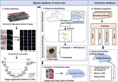
Figure 1 Flowchart of reservoir dataset development
effectively
addresses class imbalance in segmentation compared to other classification functions.
The U-Net model was executed on a workstation equipped with an NVIDIA Quadro
RTX A6,000 graphics card, running under the Cuda framework in Python. The
precision, overall accuracy, and recall rates of this model were 93%, 91%, and
88% respectively, demonstrating strong performance.
Based on the trained
U-Net model, the area time series of all types of water bodies was generated
using all cloud-free Sentinel-2 images from April to October 2022 and subsequently
verified through manual editing. Finally, the maximum area was calculated using
the area range from the time series. The goal was to uniformly represent its
boundary using the maximum extent corresponding to the largest reservoir
capacity. Although poor image quality and extensive cloud cover may lead to the
omission of the maximum reservoir area, this was overlooked due to the high
temporal resolution of Sentinel-2.
3.2.2 Reservoir
Identification
Based
on the water body extraction results, this study differentiates reservoirs from
other water bodies, such as lakes and rivers, using auxiliary data, including
river network data and high-resolution base maps. Reservoir identification in
this study follows three steps: initial identification based on river network
data, visual interpretation using high-resolution online images, and
cross-validation with other datasets.
First, a 500-m buffer zone
was created based on the high-resolution river network and used as a mask to
intersect with the extracted water body data, thereby isolating reservoir
elements. Additionally, to avoid overlooking diversion reservoirs located more
than 500 m from the river, the study intersected the 500-m buffer zone mask, created
from the river network data, with the water body dataset once more. According
to the dataset results, only 58 reservoirs were located outside the buffer zone
after this step.
Subsequently, the study refined
and corrected the initial reservoir screening results using higher-resolution
online images. A visual inspection was conducted to assess whether a dam was near
the water body polygon. If no dam was found, the water body was classified as a
lake or other types. If a dam near was present near the water body, it was
added to the dataset as a reservoir.
Finally, the
spatial range of reservoirs obtained was cross-validated with existing
datasets. The publicly available reservoir dam datasets GeoDAR, China-LDRL, and
CRD were selected and spatially matched with the dataset of this study. These
datasets were used to supplement the missing spatial records in this study. Additionally,
it was confirmed whether the spatial elements identified in this study that
were absent in the reference datasets were reservoirs. Ultimately, the exact
locations and extents of all reservoirs were manually verified.
3.2.3 Attribute
Compilation
Information on characteristics
such as reservoir storage capacity, completion time, and catchment area are
obtained from local chronicles, yearbooks, literature records, and other sources.
The total storage capacity values of reservoirs are primarily derived from
yearbooks, county annals, and online search results. The completion times of
reservoirs are obtained using 2 methods. First, the completion times of
reservoirs are gathered from textual records, with accurate completion years identified
for 716. Second, the completion or abandonment times of 81 reservoirs is
determined based on Landsat time-series images. It is assumed that the year in
which the annual average area of the reservoir water surface exceeds 0 represents
the completion year of the reservoir. Information on the completion or
abandonment times of only 7 reservoirs cannot be obtained. The elevation values
of the reservoirs are derived from SRTM DEM data. The average elevation
corresponding to the spatial extent of each reservoir is extracted from the
SRTM DEM data and used as the elevation value of the reservoir.
Additionally, for
the purpose of statistical analysis, reservoirs are classified according to their
capacity and water inflow characteristics. According to the reservoir capacity[29],
reservoirs with a capacity greater than 108 m3 are classified
as large reservoirs, those with a capacity less than 107 m3
as small reservoirs, and those with a capacity between the two as medium
reservoirs. Based on flow characteristics and referencing Chinese mountainous
area spatial range data[30,31], reservoirs are classified into two
types: mountainous reservoirs and plain reservoirs.
3.2.4 Bridging
Attributes and Geolocation
The name of a reservoir is a crucial attribute that links the spatial
and the attribute databases, serving as a marker to connect spatial location with
attribute information. The names of reservoirs, along with attributes describing
their geographical locations, such as administrative regions and associated
river basins, are sourced from Google Map or AMAP. The names are then assigned
to the reservoir vector polygons at their corresponding spatial locations.
Finally, using the reservoir names, a spatial join tool is employed to link the
spatial extent with the attribute information, including reservoir name, total
storage capacity, maximum area, elevation, completion year, and reservoir type,
among others.
4 Data Results and Validation
4.1 Dataset Composition
The dataset
is the Spatio-temporal distribution dataset of surface reservoirs in Xinjiang
(1942-2022),
comprising both spatial distribution data and tabular data. The spatial data
includes the distribution data (.shp) of large, medium-sized and small
reservoirs in Xinjiang from 1942 to 2022. The tabular data contains the general
inventory of Xinjiang Reservoirs (1942-2022) with the attributes.
4.2 Data Results
4.2.1 Spatial
Distribution Characteristics of Reservoirs
A total of 804
reservoirs (area > 0.001 km2) have been constructed in Xinjiang,
with a total storage capacity of 24.16 km3. Among them, 37 are large
reservoirs, 175 are medium reservoirs, and 592 are small reservoirs, with
storage capacities of 16.583 km3, 6.025 km3, and 1.552 km3
respectively. The statistical results (Figure 2, 3) indicate that in the
northern Xinjiang prefectures, Altay, Ili, Tacheng, Changji, Bortala, and
Urumqi have constructed 119, 45, 123, 125, 11, and 37 reservoirs, respectively,
with corresponding storage capacities of 5.290 km3, 5.093 km3,
1.478 km3, 0.834 km3, 0.140 km3, and 0.715 km3.
In eastern Xinjiang, Hami and Turpan have 62 and 15 reservoirs, respectively,
with storage capacities of 0.206 km3 and 0.220 km3.
In southern Xinjiang, Kashgar, Hotan, Aksu, Bayingolin Mongol Autonomous
Prefecture, and Kezilesu Kirgiz Autonomous Prefecture have 79, 57, 30, 29, and
23 reservoirs, respectively, with storage capacities of 4.861 km3,
0.899 km3, 1.526 km3, 1.184 km3, and 1.107 km3.
The prefecture-level cities of Cocodala, Beitun, Karamay, Shuanghe, Aral,
Huyanghe, Wujiaqu, Kunyu, and Tiemenguan have constructed a total of 49
reservoirs, with a total storage capacity of 0.608 km3. Overall, the
number of reservoirs in northern Xinjiang exceeds that in southern Xinjiang,
and the distribution of reservoirs in northern Xinjiang is more concentrated, primarily
in Changji, Bortala, Altay, and Ili. In contrast, reservoirs in southern
Xinjiang are mainly distributed near the tributaries of the Tarim River.
The number of reservoirs ineach
river basin is ranked as follows: Manas Lake Basin (134), Irtysh River Basin
(101), Bogda Region (79), Kunlun Region (60), Ili River Basin (56), Abey Lake
Basin (56), Kashgar River Basin (55), Yarkant River Basin (48), Aral Lake Basin
(45), Barkol-Yiwu Basin (37), Ulungur River Basin (30), Hami Basin (25), Tarim
River Mainstream (22), Ayding Lake Basin (18), Aksu River Basin (13), Lop Nur Region (13), Ugan River Basin (9), and Qarqan
River Basin (3). The proportion of small reservoirs is relatively high in each
river basin. For example, in the Manas Lake Basin, which has the highest number
of reservoirs, the proportion of small reservoirs reaches 71%. The storage
capacity of each river basin is ranked as follows: Ili River Basin (5.082 km3),
Irtysh River Basin (4.583 km3), Yarkant River Basin (4.437 km3),
Manas Lake Basin (2.241 km3), Kashgar River Basin (1.533 km3),
Kunlun Region (0.987 km3), Ugan River Basin (0.875 km3),
Tarim River Mainstream (0.836 km3), Ulungur River Basin
(0.803 km3), Abey Lake Basin (0.637 km3), Aksu River
Basin (0.438 km3), Lop Nur Region (0.430 km3), Aral
Lake Basin (0.365 km3), Bogda Region (0.312 km3), Ayding
Lake Basin (0.223 km3), Qarqan River Basin (0.171 km3),
Hami Basin (0.114 km3), and Barkol-Yiwu Basin (0.092 km3).
The proportion of storage capacity held by large reservoirs is relatively high in
each river basin. In river basins with large runoff, such as the Ili River
Basin, Irtysh River Basin, and Yarkant River Basin, the proportion of storage
capacity held by large reservoirs exceeds 80%. This is because in these areas
with large runoff, large reservoirs possess higher regulation and storage
capabilities.
4.2.2 Distribution of
Reservoir Construction Years
From 1942 to 2022, the number of
reservoirs in Xinjiang has steadily increased. Based on the quantity and
characteristics of reservoir construction, this period can be divided into four
stages: 1940-1960,
1960-1980,
1980-2000,
and 2000-2022.
The 1960-1980
and 2000-2010
periods were particularly peak years of reservoir construction. During 1940-1960, a total of 73 reservoirs were built, with a
cumulative storage capacity of 1.18 km3.
Small and medium reservoirs accounted for 96% of the total number, but only 68%
of the total capacity. In the 1960-1980 period, 292 reservoirs were constructed,
with a total
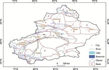
Figure 2 Spatial distribution map of reservoirs in
Xinjiang
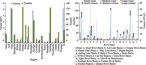
Figure 3 Statistical diagram of the number and
volume of reservoirs in Xinjiang
storage
capacity of 3.24 km3. Among these, large, medium, and small
reservoirs accounted for 2%, 22%, and 76% of the total number, respectively. The
corresponding proportions of storage capacity were 30%, 55%, and 15%. During
this period, the construction of small and medium reservoirs still dominated. From
1980 to 2000, 192 reservoirs were built, with a total storage capacity of 3.30
km3. The proportions of large, medium, and small reservoirs in terms
of number were 77%, 20%, and 3%, respectively. In terms of storage capacity, the
proportions were 51%, 39%, and 10%, respectively. During 2000-2022, 224
reservoirs were built, including 21 large reservoirs, 54 medium reservoirs, and
149 small reservoirs. Compared with the previous periods, the number of large
reservoirs has increased significantly. The total storage capacity during this
period is 16.36 km3, with the proportions of large, medium, and
small reservoirs being 83%, 14%, and 3%, respectively. The storage capacity of
large reservoirs has also risen considerably. Overall, while the number of
reservoirs has not increased dramatically, the total storage capacity has seen significant
growth, particularly after 2005. This is mainly due to the construction of
large reservoirs. It can be observed that large reservoirs, particularly in
mountainous areas, play a crucial role in water regulation and storage. The
construction of reservoirs in Xinjiang has gradually shifted towards large
reservoirs in these areas. The trend of reservoir construction in Xinjiang over
the years is illustrated in Figure 4.
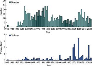
Figure 4 Statistical charts on the number and
volume of reservoirs built over the years
4.2.3 Construction of Plains and
Mountain Reservoirs
From 1942 to
2022, a total of 461 plain reservoirs and 343 mountainous reservoirs were
constructed in Xinjiang, with total storage capacities of 8.59 km3
and 15.57 km3, respectively. As shown in the statistical charts
(Figure 5), the number of plain reservoirs generally follows a decreasing
trend, while the number of mountainous reservoirs shows a steady increase, along
with their corresponding storage capacities. Before the 1980s, due to limited
construction techniques and economic conditions, the focus was primarily on building
plain reservoirs. Between 1940 and 1980, 273 plain reservoirs were constructed,
with a total storage capacity of 3.77 km3. In comparison, only 92
mountainous reservoirs were built, with a total storage capacity of 0.71 km3.
After 1980, the construction of mountainous reservoirs accelerated. From 1980
to 2000, 111 plain reservoirs were built, with a total storage capacity of 1.25
km3, while 81 mountainous reservoirs were constructed, with a total
storage capacity of 1.99 km3. During this period, the numbers of
plain and mountainous reservoirs became more comparable, but the storage
capacity of mountainous reservoirs was nearly twice that of plain reservoirs.
Since 2000, the construction of mountains reservoirs has far outpaced that of
plain reservoirs. In this period, 59 plain reservoirs were built, with a
storage capacity of 3.49 km3, while 165 mountainous reservoirs were
constructed, with a storage capacity of 12.87 km3. Both the number
and storage capacity of mountainous reservoirs now significantly exceed those
of plain reservoirs.
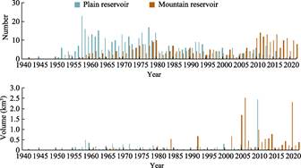
Figure 5 Statistics of the number and volume of
plain and mountain reservoirs (1940?C2022)
4.3 Comparison with Other Datasets
The spatial
distribution and attribute information of reservoirs are essential for effective
water resource management and ensuring sustainability. Remote sensing
technology has become a key tool for monitoring reservoirs dynamically, both at
the global and regional scales. In addition to remote sensing, public
statistical reports provide valuable record of reservoir data. In this study, a
spatio-temporal distribution dataset of surface reservoirs in Xinjiang was developed
by integrating high-resolution remote sensing imagery with records from water
conservancy project archives.
Most existing surface
water body change datasets conflate reservoirs with other types of water bodies,
such as lakes, or fail to separately identify reservoirs, leading to an
underestimating of the number of reservoirs in Xinjiang. For instance, GLAKES[28]
dataset only labels 19 water body elements as reservoirs. While some
inventories specifically focus on reservoirs in Xinjiang, their practical
application is often limited due to the lack of geographical references. Li??s study[15],
which analyzed the spatio-temporal distribution of reservoirs in Xinjiang using
statistical data, reported that by 2022, 751 reservoirs had been built, with a
total storage capacity of 29.776 km3. However, the findings of this
study indicate that, excluding abandoned or non-functional reservoirs, there
are currently 776 operating reservoirs, with a total storage capacity of 23.97
km3. Although the results are similar, Li??s study did not provide
spatial locations on these reservoirs. Global reservoir
datasets with spatial locations often overlook local reservoirs, resulting in
significant discrepancies in the number of
reservoirs in Xinjiang. For example, the GeoDAR[10] dataset
only identifies 16 reservoirs in Xinjiang, and most of their attribute
information is not publicly available. The CRD[13] dataset is the
most comprehensive, listing 673 reservoirs with the spatial locations and some
attribute like storage capacity and area. However, it lacks information on the construction
time of reservoirs, making it difficult to analyze temporal changes in
reservoir characteristics. In contrast (Table 3), this study, based on high- resolution
remote sensing imagery, provides a more comprehensive map of Xinjiang??s
reservoirs, visually illustrating their spatial distribution. Furthermore, this
dataset integrates records from water conservancy project archives, assigning
attributes like storage capacity, area, and elevation to each reservoir, and
analyzing the spatio-temporal changes in reservoir characteristics by incorporating
the construction time data.
Table 3 Comparison of ReservoirXinjiang_1942?C2022
with other datasets
|
Dataset
|
Domain
|
Production
time
|
Number
of reservoirs (Xinjiang)
|
Total
volume
(Xinjiang)
|
Attributes
|
|
GLAKES[28]
|
Global
|
2022
|
19
|
/
|
coordinate, area, water source, type
|
|
GeoDAR[10]
|
Global
|
2022
|
16
|
9.17 km3 (Accessible)
|
coordinate, area, capacity, reference data
sources
|
|
CRD[13]
|
China
|
2022
|
673
|
30.41 km3
|
name, coordinate, prefecture, area,
storage, type, shape, length
|
|
Li??s study[15]
|
Xinjiang
|
2022
|
751
|
29.78 km3
|
distribution, total capacity
|
|
ReservoirXin-
jiang_1942-2022
|
Xinjiang
|
2022
|
776
|
23.97 km3
|
name, coordinate, area, volume, shape
length, altitude, built year, river, basin, prefecture, type
|
5 Discussion and Conclusion
Reservoirs
are key indicators of a region??s water resource regulation and storage capacity,
making their spatial distribution and characteristics essential data for water
resource management. In this paper, the extent of reservoirs in Xinjiang was
mapped using high-resolution remote sensing images, and an attribute database
was established by integrating historical archives. This dataset covers the
spatial distribution of reservoirs built in Xinjiang from 1942 to 2022 and illustrates
the development of reservoir construction over time by incorporating
construction dates. Through data analysis, it was found that since the founding
of the People??s Republic of China, a total of 804 reservoirs have been built in
Xinjiang, with a total storage capacity of 24.16 km3. Small and
medium reservoirs dominate, making up approximately 95% of the total number of
reservoirs. However, after 2005, the proportion of large reservoirs has increased.
In terms of reservoir types, plain reservoirs predominated before 2010,
accounting for 67% of the total. Since 2010, the construction of mountainous
reservoirs has accelerated with these reservoirs now accounting for 83% of the
total number of reservoirs built during this period.
Compared to
existing datasets, the greatest advantage of this dataset is its inclusion of
time attribute for reservoirs through two methods: historical records and long-time
remote sensing time series. This approach addresses the limitations of single-phase
remote sensing, where monitoring the water surface changes of reservoirs can be
hindered by insufficient temporal resolution and the quality constraints of
remote sensing images. With the provided time attribute, this dataset
effectively captures the spatio-temporal changes of reservoirs in Xinjiang and
the development of water conservancy, offering valuable insights for water
resource utilization and planning. Additionally, by integrating multi source
remote sensing images and historical archive materials, the dataset combines
the strengths of both data sources, creating a completer and more reliable
spatial and attribute database for Xinjiang??s reservoirs. The Spatio-temporal distribution
dataset of surface reservoirs in Xinjiang (1942-2022) provides comprehensive data
support for water resource allocation and enhancing water resource utilization
efficiency, while also serving as a reference for future reservoir construction
in Xinjiang.
Author Contributions
Li, J. L. and Du, W. B. made the overall design for
the dataset development; Li, S. S. and Jin, J. Y. collected and processed data
on the max extent and attributes of reservoirs in Xinjiang; Li, S. S. and Wang,
H. Y. designed the models and algorithms; Li, S. S. and
Liu, S. Q. completed the data validation; Li, S. S. and Li, J. L. wrote the paper.
Conflicts
of Interest
The
authors declare no conflicts of interest.
References
[1]
Chinese Academy of Engineering, ??Research on water
resources strategy for sustainable development of China in the 21st century??
project team. Comprehensive report on China??s sustainable development water
resources strategy [J]. China Water Resources, 2000(8): 5?C17.
[2]
Tang, Q. C. The development in
oases and rational use of water resources [J]. Journal of Arid Land Resources
and Environment, 1995, 9(3): 107?C112.
[3]
Deng, M. J. ??Three Water Lines?? strategy: its
spatial patterns and effects on water resources allocation in northwest China [J].
Acta Geographica Sinica, 2018, 73(7): 1189?C1203.
[4]
Liu, T. Research on
joint-dispatching of mountain-plain reservoirs in the Yarkant River Basin [J]. Hydro
Science and Cold Zone Engineering, 2023, 6(4): 68?C71.
[5]
Perin, V., Tulbure, M. G.,
Gaines, M. D., et al. A multi-sensor
satellite imagery approach to monitor on-farm reservoirs [J]. Remote Sensing of Environment, 2022,
270: 112796.
[6]
Vu, D. T., Dang, T. D.,
Galelli, S., et al. Satellite
observations reveal 13 years of reservoir filling strategies, operating rules,
and hydrological alterations in the Upper Mekong River basin [J]. Hydrology and Earth System Sciences,
2022, 26(9): 2345-2364.
[7]
Liu, C., Tang, H. R., Ji, L. Y., et al.
Spatial-temporal water area monitoring of the Miyun Reservoir using remote
sensing imagery from 1984 to 2020 [J]. National Remote Sensing Bulletin,
2023, 27(2): 335?C350.
[8]
Mulligan, M., van Soesbergen,
A., S??enz, L. GOODD, a global dataset of more than 38,000 georeferenced dams [J].
Scientific Data, 2020, 7(1): 31.
[9]
Khandelwal, A., Karpatne, A.,
Ravirathinam, P., et al. ReaLSAT, a
global dataset of reservoir and lake surface area variations [J]. Scientific Data, 2022, 9(1): 356.
[10] Wang, J., Walter, B. A., Yao, F., et al. GeoDAR: georeferenced global dams and reservoirs dataset for
bridging attributes and geolocations [J]. Earth
System Science Data, 2022, 14(4): 1869-1899.
[11] Zhang, A. T., Gu, V. X. Global Dam Tracker: a database of more than
35,000 dams with location, catchment, and attribute information [J]. Scientific Data, 2023, 10(1): 111.
[12] Wang, X., Xiao, X., Qin, Y., et
al. Improved maps of surface water bodies, large dams, reservoirs, and
lakes in China [J]. Earth System Science
Data, 2022, 14(8): 3757-3771.
[13] Song, C., Fan, C., Zhu, J., et al. A comprehensive geospatial
database of nearly 100,000 reservoirs in China [J]. Earth System Science Data, 2022, 14(9):
4017-4034.
[14] Zhang, H., Chen, F., Wang, L., et
al. Reservoir inventory for China in 2016 and 2021 [J]. Scientific Data, 2023, 10(1): 609.
[15]
Li, J., Liu, Y., Peng, Z. X., et al.
Characteristics and construction managementideas of reservoir dams in Xinjiang [J].
China Water Resources, 2023(16): 41-46.
[16] Lehner, B., Liermann, C. R., Revenga, C., et al. High-resolution mapping of the world??s reservoirs and dams
for sustainable river-flow management [J]. Frontiers
in Ecology and the Environment, 2011, 9(9): 494-502.
[17] Li, J., Liu, Y., Wu, T., et al. 70 years of dam construction
in Xinjiang [J]. Journal of China Institute of Water Resources and
Hydropower Research, 2020, 18(5): 322-330.
[18] Deng, M. J., Yu, H. M., Li, X. Q., et al. Dam construction
progress in Xinjiang [J]. Water Resources and Hydropower Engineering,
2010, 41(7): 29-35.
[19]
Li, S. S., Li, J. L., Du, W. B.,
et al. Spatio-temporal dataset of reservoirs in Xinjiang Uygur
Autonomous Region, China (1942-2022)
[J/DB/OL]. Digital Journal of Global Change Data Repository, 2025.
https://doi.org/10.3974/geodb.2025.01.01.V1.
[20]
GCdataPR
Editorial Office. GCdataPR data sharing policy [OL].
https://doi.org/10.3974/dp.policy.2014.05 (Updated 2017).
[21] Fuyun County Party History Local Chronicles Compilation Committee.
Fuyun County Chronicle [M]. Urumqi: Xinjiang People??s Publishing House, 2003.
[22]
Qiemo County Local Chronicles Compilation Committee.
Qiemo County Chronicle [M]. Urumqi: Xinjiang People??s Publishing House, 1996.
[23]
Kuitun City Local Chronicles Compilation Committee.
Kuitun City Chronicle [M]. Beijing: Zhonghua Book Company, 1999.
[24] Kashgar Local Chronicles Compilation Committee. Kashgar Prefecture Chronicles
[M]. Urumqi: Xinjiang People??s Publishing House, 2004.
[25] Korla City Local Chronicles Compilation Committee. Korla City Chronicle
1991?C2005 [M]. Urumqi: Xinjiang People??s Publishing House, 2017.
[26]
Xinjiang Aksu River Basin Management Office.
Chronicles of the Aksu River Basin [M]. Beijing: Local Records Publishing
House, 2006.
[27] Zhao, X., Wang, H., Liu, L., et
al. A method for extracting lake water using ViTenc-UNet: taking typical lakes
on the Qinghai-Tibet Plateau as examples [J]. Remote Sensing, 2023, 15(16): 4047.
[28] Pi, X., Luo, Q., Feng, L., et
al. Mapping global lake dynamics reveals the emerging roles of small lakes [J].
Nature Communications, 2022, 13(1):
5777.
[29] Ministry of Water Resources of the People??s Republic of China.
Standard for rank classification and flood protection criteria of water and
hydropower projects (SL 252??2017) [S]. Beijing: China Water & Power Press,
2017.
[30] Deng, W., Li, A. N., Nan, X., et al. Digital Mountain Map of
China [M]. Beijing: China Map Publishing House, 2015.
[31] Nan, X., Li, A. N., Deng, W. Dataset of ??Digital mountain map of
China?? (2015) [DB/OL]. A Big Earth Data Platform for Three Poles, 2022.