The Lower Timberline Dataset in the Upper Reaches of the Min River, China (1999-2009)
Wang, Q.* Guo, Y. L. Zhai, Z.
School of Environment and Resource, Southwest University of Science and Technology, Mianyang 621010, China
Abstract: The lower timberline is a special geo-ecological phenomenon in the arid valley. Research on the geographic distribution and displacement process of the lower timberline is an effective way to reveal the natural change process of the mountain environment and the environmental effects of human activity, which can provide the basic data support for the research of regional responses under the background of global climate change and human interference. Based on the data integration among the SPOT-2, SPOT-4, SPOT-5, Google Earth images, ASTER GDEM, as well as a vegetation map, the distribution dataset of the lower timberline in the Upper Reaches of the Min River in 1999 and 2009 was developed. Meanwhile, 149 sample points were collected in the distribution area of the lower timberline in the Upper Reaches of the Min River through field investigation. The results showed: (1) the lower timberline was characterized by cluster distribution and mainly concentrated in the upper part of the V-shaped valley ranged from 1,400 m to 3,800 m and on the slopes of 6°-15°. In different slope directions, the lower timberline on the southern slope was obviously higher than that on the northern slope, and that in the eastern part was higher than that in the western. (2) From 1999 to 2009, under the combination of human activities and natural factors, the spatial displacement of the timberline in the settlement area was significantly different from that in the non-settlement area. The dataset is archived in .shp, .tif, .kmz and .xslx data formats with a data size of 1.39 MB. The analysis paper was published in Geographical Research, 2015, Vol. 34.
Keywords: the Upper Reaches of the Min River; forest community; the lower timberline; sample point
1 Introduction
The Upper Reaches of the Min River (URMR) is a unique eco-tone in the mountain areas of Southwest China, located in the transition zone between the edge of the Sichuan Basin and the Tibetan Plateau in China (30°45′N-33°09′N, 102°35′E-103°56′E)[1]. Affected by the special geographical location, topographic conditions, climatic characteristics, soil types and other factors, a mixed eco-tone of the foliage shrubs, deciduous broad-leaved forests and isolated “tree islands” has been formed at the altitude of about 2,200 m, in the upper part of the arid valley in URMR, which is defined as “the lower timberline”[2–4]. The lower timberline not only exists in the arid valley of URMR, but also a widespread geographical and ecological phenomenon in arid valley of the Hengduan Mountains. Furthermore, the fluctuation of the lower timberline is one of the response characteristics of regional ecological environment to climate change [5]. Related research can provide a new way for exploring the relationship between mountain environmental changes and environmental influence from anthropic activities. The lower timberline dataset in the Upper Reaches of the Min River, China (1999-2009)[6] is an important achievement in the study of climate change and regional response.
2 Metadata of Dataset
The metadata of the Lower Timberline Dataset in the Upper Reaches of the Min River,
China (1999-2009)[6] is summarized in Table 1. It includes the dataset full name, short name, authors, year of the dataset, temporal resolution, spatial resolution, data format, data size,
Table 1 Metadata summary of the lower timberline dataset in the Upper Reaches of the Min River, China (1999-2009)
|
Items
|
Description
|
|
Dataset full name
|
The lower timberline dataset in the Upper Reaches of the Min River, China (1999-2009)
|
|
Dataset short name
|
LowerTimberlineMinjiang_1999-2009
|
|
Authors
|
Wang, Q. L-5245-2016, Southwest University of Science and Technology, qingw@imde.ac.cn
Guo, Y. L. L-5221-2016, Southwest University of Science and Technology, guoyalin_linda@163.com
Zhai, Z. L-5227-2016, Southwest University of Science and Technology, zhaizhen12321@163.com
|
|
Geographical region
|
The geographical region covers 31°17′4″N - 32°25′49″N and 102°54′56″E - 103°54′22″E, mainly including the arid valley in Wenchuan county, Li county, Mao county, Heishui county and Songpan county in Ngawa Tibetan and Qiang Autonomous Prefecture, Sichuan Province, China
|
|
Year
|
1999, 2009
|
|
Temporal resolution
|
Ten year
|
Spatial resolution
|
10 m, 5 m
|
|
Data format
|
shp, .tif, .kmz, .xslx
|
Data size
|
1.39 MB
|
|
Data files
|
The major parts of the dataset are as follows: (1) 149 sample sites geo-location data with the surrounding information; (2) distribution data of vegetation communities; (3) lower timberline data in non-settlement area; (4) lower timberline data in settlement area; (5) lower timberline data in 1999; (6) lower timberline data in 2009; (7) statistics of the relationship between the lower timberline and its distribution in elevation
|
|
Foundation(s)
|
Ministry of Science and Technology of P. R. China (2015BAC05B05-01); National Natural Science Foundation of China (41071115); Sichuan Province (2012SZ0175, 2013SZ0101, 2014SZ0058, 2014SZ0063)
|
|
Data publisher
|
Global Change Research Data Publishing & Repository, http://www.geodoi.ac.cn
|
|
Address
|
No. 11A, Datun Road, Chaoyang District, Beijing 100101, China
|
|
Data sharing policy
|
Data from the Global Change Research Data Publishing & Repository includes metadata, datasets (data products), and publications (in this case, in the Journal of Global Change Data & Discovery). Data sharing policy includes: (1) Data are openly available and can be free downloaded via the Internet; (2) End users are encouraged to use Data subject to citation; (3) Users, who are by definition also value-added service providers, are welcome to redistribute Data subject to written permission from the GCdataPR Editorial Office and the issuance of a Data redistribution license; and (4) If Data are used to compile new datasets, the ‘ten per cent principal’ should be followed such that Data records utilized should not surpass 10% of the new dataset contents, while sources should be clearly noted in suitable places in the new dataset[7]
|
data files, data publisher, and data sharing policy, etc.
3 Methods
The development of the geographical distribution of the lower timberline in URMR was mainly based on the sample point dataset of field survey and the remote sense data of SPOT-2/4 and SPOT-5. The Google Earth images, ASTER GDEM and vegetation map were also used for improving the accuracy and quality of data extraction.
3.1 Acquisition of Sample Point Data in Field Survey
|
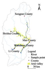
Figure 1 Sample points distribution of the Upper Reaches of the Min River (URMR)
|
Using the geographic field survey model and
selecting the intersection point of roads, river inflection point, house and other characteristic positions, the investigation and interpretation of the lower timberline was developed. In the process of investigation, two people recorded the information of longitude, latitude, elevation, surface cover features of the
surrounding mountains simultaneously, and photographed the landscape. In the collation stage of the data, keeping the consistent of the surrounding information of a feature point recorded by the two
people. Furthermore, according to the latitude and longitude information, 149 recorded points that had the high degree of coincidence on geographic locations with the point that extracted from the Google Earth online images were filtered (Figure 1), of which 88 sample points as control points and 61 samples as the verification points.
3.2 Extraction of the Lower Timberline
Adopting ERDAS IMAGINE 9.2 software and taking the sample point as geographical reference, the SPOT images were preprocessed, such as geometric correction, orthogonal correction, image fusion, image mosaic, and image clipping, in the WGS_1984_UTM _Zone_48N coordinate system (central meridian at 105°E). The resolution of the fused images in 1999 and 2009 was 10 m and 5 m, respectively.
With the vegetation map[8] of the study area for reference, the lower timberlines in 1999 and 2009 were interpreted by two people simultaneously (Figure 2), which were mainly based on vegetation types, image color, and texture features. The consistency of interpretation results were checked by using the maximum likelihood method: when the consistent rate was more than 90 %, the inconsistent part was modified through consultation; when the consistent rate was less than 90 %, the re-interpretation was conducted. In addition, the lower timberline in the settlement area was distinguished from that in the non-settlement area (Figure 3) based on the obvious difference on image textures and tones between the natural area and the anthropic zone. Based on the field survey data, the results of visual interpretation were verified one by one, and the data with errors were deleted or modified, resulting in the discontinuous line segment of the lower timberline.
|
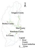
Figure 2 Spatial distribution of the lower timberline in URMR in 2009
|
|
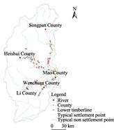
Figure 3 Distributions of typical settlements and non-settlement points near the lower timberline in URMR[5]
|
4 Results and Validation
4.1 Data Products
The lower timberline dataset in URMR (1999-2009) (Table 2) consists of the data of the lower timberline in 1999 and 2009, vegetation types, 149 sample sites geo-location data with the surrounding information, the lower timberline data in settlement area and non-settlement area, and the statistics on the distribution of the lower timberline at different altitudes.
Table 2 Composition of the lower timberline dataset in the Upper Reaches of the Min River (1999-2009)
|
No.
|
Data File Name
|
Data Size (KB)
|
Data Description
|
|
1
|
LowerTimberLine1999.shp
|
489.35
|
Vector data of the lower timberline in 1999
|
|
2
|
LowerTimberLine2009.shp
|
509.99
|
Vector data of the lower timberline in 2009
|
|
3
|
SampleSites.shp
|
111.74
|
Vector data of sample sites
|
|
4
|
DataDescription.txt
|
0.208
|
Data description for the vector data of sample sites
|
|
5
|
TypicalNonSettlementPoint.shp
|
7.71
|
Vector data of the typical non-settlement points
|
|
6
|
TypicalSettlementPoint.shp
|
7.70
|
Vector data of the typical settlement points
|
|
7
|
VegetationType_UpperMinRiver.tif
|
40.27
|
Raster data of vegetation types
|
|
8
|
Sta_LowerTimberLine_Altitude.xls
|
384
|
Relationship of the lower timberlines and the altitudes
|
|
9
|
_LowerTimberLine1999.kmz
|
333.97
|
Landmark information of the lower timberline in 1999
|
|
10
|
_LowerTimberLine2009.kmz
|
352.86
|
Landmark information of the lower timberline in 2009
|
|
11
|
_SampleSites.kmz
|
10.79
|
Landmark information of sample sites
|
|
12
|
_TypicalNonSettlementPoint.kmz
|
3.25
|
Landmark information of the typical non-settlement points
|
|
13
|
_TypicalSettlementPoint.kmz
|
3.30
|
Landmark information of the typical settlement points
|
The data indicated that: (1) the discontinuous lower timberline in URMR was located near the upper boundary of the arid valley. The altitude of the lower timberline ranged from 1,400 m to 3,800 m, with a normal distribution at the center of 2,600 m (Figure 4). The distribution slope of the lower timberline was mainly below 25 degrees and the per cent of lower timberline reached the peak on the slopes of 6°-15°. Moreover, the lower timberline on the southern slope was obviously higher than that on the northern slope, and that in the eastern part was higher than that in the western. (2) the length of lower timberline increased from 2009 to 1999[5].
4.2 Validation
From 2013 to 2015, the fixed-point field verification of the lower timberline in URMR was conducted by selecting typical settlements in Li county and Wenchuan county.
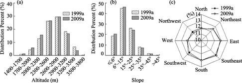
Figure 4 Distribution characteristics of the lower timberline in URMR under different terrain conditions
5 Conclusion
The lower timberline is restricted by temperature or heat conditions, the formation of the lower timberline is closely related to the vertical change of moisture and the lower timberline can show obvious changes within the span of 5-10 years[5]. The development of the dataset was based on the high resolution satellite imagery and the comprehensive application of traditional field survey methods and GIS technology in regional geography. It can effectively reveal the spatial heterogeneity and displacement mechanism of the lower timberline.
Author Contributions
Wang, Q. designed the algorithms of dataset. Guo, Y. L. and Zhai, Z. contributed to the data processing and analysis. Wang, Q. and Guo, Y. L. wrote the data paper.
References
[1] Wang, Q., Guo, Y. L. Boundary data of the Upper Reaches of Min River Basin, China [DB/OL]. Global Change Research Data Publishing & Repository, 2016. DOI: 10.3974/geodb.2016.05.01.V1.
[2] Zhang, R. Z. The Dry Balleys of the Hengduan Mountains Region [M]. Beijing: Science Press, 1992: 1-19.
[3] Wang, Q., Shi, M. Q., Guo, Y. L., et al. The vertical differentiation of the mountain settlement niche in the Upper Reaches of Minjiang River [J]. Acta Geographica Sinica, 2013, 68(11): 1559-1567.
[4] Yang, Q. Z. Study on the arid valley scrubs in the Upper Reaches of Minjiang River [J]. Journal of Mountain Science, 2007, 25(1): 1-32.
[5] Zhai, Z., Wang, Q. The geography distribution pattern and spatial move of the lower timberline in the Upper Reaches of Minjiang River [J]. Geographical Research, 2015, 34(11): 2105-2112.
[6] Wang, Q., Zhai, Z. The lower timberline dataset in the Upper Reaches of Minjiang River, China (1999-2009) [DB/OL]. Global Change Research Data Publishing & Repository, 2016. DOI: 10.3974/geodb.2016.04.18.V1.
[7] GCdataPR Editorial Office. GCdataPR Data Sharing Policy [OL]. DOI: 10.3974/dp.policy.2014.05 (Updated 2017).
[8] Editorial Board of Vegetation Map of China, Chinese Academy of Sciences. Vegetation Atlas of China [M]. Beijing: Science Press, 2001: 65-68, 97-100.