Global Change Data Encyclopedia
Dataset of Dongjiang Lake Basin
Xu, J.1, 2 Xiao, Y.1* Xie, G. D.1 Wang, S.3 Zhu, W. B.1
1. Institute of Geographic Sciences and Natural Resources Research, Chinese Academy of Sciences, Beijing
100101, China;
2. University of Chinese Academy of Sciences, Beijing 100049, China;
3. Surveying and Mapping Development Research Center, NASG, Beijing 100830, China
Keywords: Dongjiang Lake; basin; Xiangjiang River; boundary; data encyclopedia
|
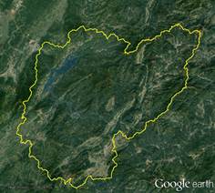
Figure 1 Dataset map of Dongjiang Lake and its basin in .kmz data format
|
Dongjiang Lake is located at the junction of Hunan, Guangdong and Jiangxi provinces and to the south of Zixing, Hunan. It lies south of the Luoxiao Mountains, at the western slope of Bamian Mountain and the northern slope of Nanling Mountain (Figure 1). The geo-location of the lake is 25°35′46″N in south, 26°00′10″N in north, and 113°17′52″E in the west, 113°41′48″E in the east [1]. It is part of the Rugui Mountains and is a medium-low mountainous area and its terrain reduces from east to west. The total area of the lake is 156.84 km2, the boundary of the lake is 722.70 km long.
There are 44 islands in the lake, the biggest of which is Doulvyan Island, covering an area of 6 km2. Dongjiang Lake is located upstream of the Leishui River, a tributary of the Xiangjiang River which originates from the Dongjiang water system in Guidong, enters through Rucheng from the southeast. It runs into Leishui River via the Dongjiang Lake together with the Yongle River water system on the west side of Bamian Mountain and goes through the northeastern corner of the city.
The Dongjiang Lake basin is the catchment area of rivers flowing into the Dongjiang Lake. The geo-location of the basin is 25°20′51″N in the south, 26°10′30″N in the north, and 113°13′26″E in the west, 114°3′00″E in the east. The area of the basin is 4,851.04 km2 and the boundary length is 435.62 km. The river system in the basin is developed with the Dongjiang River and Yongle River injecting into the Dongjiang Lake, water rich, water energy resources rich. There are 819 rivers in the basin, with a total length of 53.9 km, of which there are 22 rivers with catchment area over 50 km2, and 135 rivers with catchment area over 10 km2. Oujiang River originates from the Yanzhubao, Guidong county, and the main tributaries are Zheshui River, Chushui River and Qijiang River.
In the Dongjiang Lake basin, the highest elevation is 1,691 m located in Bamian Mountain and minimum is 180 m in Dongjiang Dam in Zixing city. Dongjiang Lake features a typical mid-subtropical monsoon climate, its annual rainfall averages 1,645 mm, which is uneven in time and space and the rainstorm is most frequent between April and August. The annual average evaporation was 1,515 mm and the annual average temperature is 13.7-18.7 °C with highest temperature of 16.9 °C and the lowest temperature of -7.5 °C. The average sunshine hours is 1,478 h. Soil types in the basin are mainly red soil, yellow red soil, yellow brown soil, mountain meadow soil and purple soil, etc. The basin belongs to the subtropical evergreen broad-leaved forest belt with diverse vegetation types and the forest coverage rate reaches 72%. Affected by the human economic activity as well as the altitude above sea level, the vegetation types are artificial timber forest, economic forest and cultivated cropland, secondary forest, mixed broadleaf-conifer forest, mixed broadleaf-conifer forest and artificial forest, natural mixed evergreen deciduous broadleaf forest and meadow community full of wild grass, miscanthus sinensis, miscanthus floridulus herbs, etc from low to high respectively. Zixing City and Guidong County in the Dongjiang Lake Basin are both National Ecological Protection Area and the Bamian Mountain National Nature Reserves and the Tian’e Mountain National Forest Park.
There are 78 species of fish, 87 species of birds, 244 wild animals and 1246 wild plants. Among them, 30 species of wild plants, such as ginkgo biloba, silver fir and southern yew, are included in the national key protection category; there are 34 species of wild animals protected by the state, such as the deer and the red falcon, 14 species of protected species under the international trade convention and four species of endangered species listed in China’s red book of endangered species. Most of the other species are Hunan Province’s key conservation targets, accounting for 80% of total amount in the province. The Dongjiang Lake Basin is an important pilot area of national wetland park, national key river basin and pilot area of water resources ecological compensation. There are 41 towns and villages in 4 counties and cities in the basin which is Rucheng county, Guidong county, Yizhang county, and Zixing city.
The boundary data of the Dongjiang Lake basin was developed based on the ASTER-DEM[3] with the statistic models in ArcSWAT and validated by the Google Earth images. The data is composed of line and polygon coverages with 15 data files, which are archived in both .kmz and .shp data formats with the data size of 2.63 MB in compressed.
References
[1] Xu, J., Xiao, Y., Xie, G. D., et al. Boundary data of the Dongjiang Lake basin [DB/OL]. Global Change Research Data Publishing & Repositry, 2017. DOI: 10.3974/geodb.2017.03.20.V1.
[2] NASA EOSDIS Land Processes DAAC (Distributed Active Archive Center), USGS, Earth Resources Observation and Science (EROS) Center, ASTER-DEM [Z]. https://lpdaac.usgs.gov/dataset_discovery/aster. DOI: 10.5067/ASTER.
[3] Xu, J, Xiao, Y, Xie, G. D., et al. Spatiotemporal analysis of water supply service in the Dongjiang Lake basin [J]. Acta Ecologica Sinica, 2016, 36(15): 4892-4906. DOI: 10.5846/stxb201507011398.