Hu, J. L.1 Luo, M. L.2, 3*
Tang, M. G.4 Wei,
L.5 Yan, Z. H.2 Qin, Z. H.2
1. School
of Civil Engineering and Geomatics, Southwest Petroleum University, Chengdu
610500, China;
2. School
of Land and Resources, China West Normal University, Nanchong 637002, China;
3. Sichuan
Provincial Engineering Laboratory of Monitoring and Control for Soil Erosion on
Dry Valleys, China West Normal University , Nanchong 637009, China
4.
Institute of Geographic Sciences and Natural Resources Research, Chinese
Academy of Sciences, Beijing 100101, China;
5. Yingjing
Natural Resources and Planning Bureau, Ya??an 625200, China
Abstract:
Plateau mountain is a large plateau with a large average height, vast area,
complex structure. The Liangshan plateau mountain is one of the typical plateau
mountain areas in China, located at the southwest edge of the Sichuan basin.
This study produced a dataset of integrated mountain characteristic elements in
Liangshan plateau mountain based on the SRTM3 DEM data with a resolution of 90
m. Firstly, the integration extraction method is used to identify the
ridgelines and their grades and the corresponding mountain areas. Then, the
results are validated and corrected using the fuzzy membership and Google Earth
image data. This dataset consists of 5 parts: (1) the boundary of Liangshan
plateau; (2) the mountain area data; (3) the ridgeline data; (4) the ridgeline
data obtained by using the fuzzy membership; (5) the contour data with a
contour interval of 100 m. The dataset is archived in .shp, .tif, and .txt
formats and is composed of 55 data files, with a data size of 29.6 MB
(compressed into one file, 14.9 MB).
Keywords: mountain characteristic element;
ridgeline; Liangshan plateau mountain
DOI: https://doi.org/10.3974/geodp.2022.01.19
CSTR: https://cstr.escience.org.cn/CSTR:20146.14.2022.01.19
Dataset Availability Statement:
The dataset supporting this
paper was published and is accessible through the Digital Journal of Global Change Data Repository at:
https://doi.org/10.3974/geodb.2021.10.09.V1 or https://cstr.escience.org.cn/CSTR:20146.11.2021.10.09.V1.
1 Introduction
Mountains
are one of the essential topographies that influence climate and the
geographical distribution of flora and fauna[1,2]. Mountain
characteristic elements characterize mountain topography and undulations, which
are the important indicators to describe regional geomorphological features[3,4].
In recent years, the extraction and analysis of characteristic elements have
become one of the research hotspots in Digital Terrain Analysis. However, current
researches focus on the extraction and analysis of single characteristic
elements, such as mountain peaks[5?C7] or feature lines[8?C10],
while there is a lack of relation between these characteristic elements. Hu et al. proposed an integration
extraction method of mountain characteristic elements[11], which
extracting the mountain areas and the mountain characteristic elements based on
the DEM data simultaneously. The obtained mountain areas are complete, and the
mountain characteristic elements are well coupled, which is consistent with
geomorphological cognition.
Plateau mountain
is a large plateau with a large average height, vast area, complex structure.
It includes mountains, plateaus and intermountain basins, etc., forming a
complicated complex[12]. The Liangshan plateau mountain is one of
the typical plateau mountain areas in China, located in the southwest edge of
the Sichuan basin. It extends from the Dadu river in the north to the Puxiong
river, the Niger river, the Mandan river, and the Niuri river in the west and
is bounded by the Jinsha river valley in the southeast, covering an area of
nearly 9,000 km2. It is a typical mountainous area because of its
fragmented surface cut, undulating topography, and steep slopes. This dataset
is based on the integration extraction method proposed by Hu et al.[11] to obtain the
mountain characteristic elements of the Liangshan plateau mountain. On this basis,
we got nine main ridgelines after post-processing and manual correction. The
dataset results can reflect the overall geomorphological structure of the
region, and the division of mountains conforms to the geomorphology
recognition. Meanwhile, the characteristic elements?? structure is consistent
with the affiliation structure, and the coupling relationship between them is
great. The dataset can assist in the geomorphological classification and zoning
of the Liangshan plateau mountain, and helpful attempts have been made to the
mountain characteristic element extraction and geomorphological zoning.
2 Metadata of the Dataset
The
metadata of the Dataset of mountain characteristic elements in Liangshan mountain[13] is
summarized in Table 1. It includes the dataset full name, short name, authors,
year of the dataset, temporal resolution, spatial resolution, data format, data
size, data files, data publisher, and data sharing policy, etc.
3 Data Development Method
This
dataset is produced based on the SRTM3 DEM surveyed by the U.S. Space Shuttle radar.
The DEM data was collected in February 2000, and the processed spatial
resolution was three arc seconds (approximately 90 m near the equator). This
study uses the SRTM3 data provided by the Geospatial Data Cloud[1] with the original data in
the WGS84 coordinate system. In this study, the data is projected into the
WGS_1984_ Lambert_ Conformal_Conic coordinate system, and the resolution is
resampled to 90 m.
3.1 Method Principle
This
dataset is based on the integration extraction method proposed by Hu et al.[11] to obtain the
mountain characteristic elements of the Liangshan plateau mountain. The main
process includes that: (1) extraction of peaks and the corresponding control
areas by natural terrain segmentation; (2) ridgeline extraction by watershed
boundary filtering; (3) the membership degree W calculation for each ridgeline;
(4) ridgeline level coding at all levels; (5) coupling of peaks, ridgelines,
and peak control areas. Among them, the membership degree W is determined by
Equation (1):
 (1)
(1)
where
AS denotes the average slope, AE denotes the average elevation, and AD represents the average deviation. In
addition, the fuzzy membership[16] is used for the main ridgeline
identification to verify the mountain characteristic elements.
Table
1 Metadata summary of the Dataset of mountain
characteristic elements in Liangshan mountain[13]
|
Items
|
Description
|
|
Dataset full name
|
Dataset of mountain
characteristic elements in Liangshan mountain
|
|
Dataset short
name
|
Ridgeline&MountainareaLiangshan
|
|
Authors
|
Hu, J. L. 0000-0002-8123-7282, School of Civil Engineering and
Geomatics, Southwest Petroleum University, ltpai91@hotmail.com
Luo, M. L., School of Land and Resources, China
West Normal University, lolean586@163.com
Tang, M. G., Institute of Geographic Sciences and Natural Resources
Research, Chinese Academy of Sciences, baymintang@hotmail.com
Wei, L., Yingjing Natural Resources and Planning Bureau, 1324265289@qq.com
Yan, Z. H., School of Land and Resources, China West Normal
University, 2327626923@qq.com
Qin, Z. H., School of Land and Resources, China West Normal
University, qinzihan2021@126.com
|
|
Geographical region
|
Liangshan plateau
mountain
|
|
Year
|
2000
|
|
Spatial
resolution
|
90 m
|
|
Data format
|
.shp, .tif, .txt
|
|
|
|
Data size
|
29.6 MB (14.9 MB
after compression)
|
|
|
|
Data files
|
the boundary of
Liangshan plateau mountain
the mountain area
data
the ridgeline
data
the ridgeline
data obtained by using the fuzzy membership
the contours with
100m contour interval
|
|
Foundation
|
National Natural
Science Foundation of China (41871324)
|
|
Data publisher
|
Global Change Research Data Publishing & Repository,
http://www.geodoi.ac.cn
|
|
Address
|
No. 11A, Datun
Road, Chaoyang District, Beijing 100101, China
|
|
Data sharing
policy
|
Data from the Global
Change Research Data Publishing & Repository includes metadata, datasets (in the Digital Journal of Global Change Data Repository), and
publications (in the Journal of Global Change Data & Discovery). Data sharing policy includes: (1) Data are openly
available and can be free downloaded via the Internet; (2) End users are
encouraged to use Data subject to citation; (3) Users, who are by definition
also value-added service providers, are welcome to redistribute Data
subject to written permission from the GCdataPR Editorial Office and the
issuance of a Data redistribution license; and (4) If Data are used to compile
new datasets, the ??ten percent principal?? should be followed such that Data
records utilized should not surpass 10% of the new dataset contents, while
sources should be clearly noted in suitable places in the new dataset[7]
|
|
Communication and searchable system
|
DOI,
CSTR, Crossref, DCI, CSCD, CNKI, SciEngine, WDS/ISC, GEOSS
|
3.2 Implementation
The
process of generating this dataset includes data preprocessing, mountain
characteristic extraction, and data post-processing, and the main process is
shown in Figure 1. Firstly, the data preprocessing consists of calibrating the
original range of the Liangshan plateau, DEM data cropping, and raster
reprojection. Then, the mountain characteristic extraction consists of mountain
characteristic element extraction by the integration extraction method and the
main ridgeline identification by the fuzzy membership. Finally, the data
post-processing contains a manual correction of characteristic elements, name calibration
of the main ridgeline, and data integration. Among them, the manual correction
is based on Google Earth Map, Google Earth Topographic Map, and experts??
experience, its?? main processes include that: (1) ridgeline alignment
correction; (2) mountain boundary correction; (3) adjacent mountain without
obvious division merging; (4) boundary correction of the Liangshan plateau
mountain.
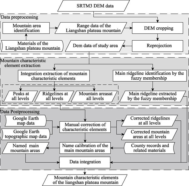
Figure 1 Flowchart
of the dataset development
4 Data Results and Validation
4.1 Data Composition
The
dataset consists of the Liangshan plateau mountain range data, the mountain
area data, the ridgeline data, the ridgeline data obtained by the fuzzy
membership, and the contour data with a contour interval of 100 m. The details
are shown in Table 2.
4.2 Data Results
After
manual correction, this dataset contains a total of 9 main mountain areas and
232 mountain areas at all levels; 9 main ridgelines and 1,849 ridgelines at all
levels. The peaks at all levels are all eliminated because there is no known
data for verification. The corrected mountain characteristic element data are
shown in Figure 2.
Table 2 The composition files of the dataset of
integrated mountain characteristic elements in Liangshan plateau mountain
|
Data name
|
Data format
|
Data type
|
Data size
|
|
The boundary of
Liangshan plateau mountain
|
.shp
|
Vector
|
81.63 KB
|
|
The main
mountain area data
|
.shp
|
Vector
|
226.42 KB
|
|
The mountain
area data at all level
|
.shp
|
Vector
|
788.13 KB
|
|
The main ridgeline data
|
.shp
|
Vector
|
197.07 KB
|
|
The ridgeline data at
all level
|
.shp
|
Vector
|
2.09 MB
|
|
The ridgeline
data obtained by using the fuzzy membership
|
.tif
|
Raster
|
753.05 KB
|
|
The contours with an interval of 100 m
|
.shp
|
Vector
|
25.55 MB
|

Figure 2 Corrected
mountain characteristic elements
To further improve the data quality and facilitate
the subsequent use of the data, the names of each main ridgeline were
determined by the county records of Ganluo county, Meigu county, and Mabian
county and related materials, and the results are shown in Table 3.
Table
3 The names of the main ridgeline of
Liangshan plateau mountain
|
Number
|
Mountain name
|
Naming materials
|
|
1
|
Mountain in
central Liangshan
|
County Record of
Ganluo[17,18]
|
|
2
|
Mountain in
central Liangshan, Amiteluo
|
County Record of
Ganluo
and Meigu[17?C20]
|
|
3
|
Dafengding,
Huangmaogeng, Lianzhaguoe, Jigongshan
|
County Record of
Meigu and Mabian[19?C21]
|
|
4
|
Tekehonghongshan
|
Materials of Ganluo[22]
|
|
5
|
Wahounenghe
|
Materials of Meigu[22]
|
|
6
|
Yaozishan,
Dahuageng
|
Materials of Mabian[22]
|
|
7
|
Laisigang, Dayougang
|
County Record of
Mabian[21]
|
|
8
|
Maniegu, Chatiaoshan
|
County Record of
Mabian[21]
|
|
9
|
Mamizhe
|
County Record of
Mabian[21]
|
|
Note: Local county records, such as the
county record of Ganlao, are obtained by consulting local county records.
|
4.3 Data Validation
The
main mountain area and ridgeline data at all levels after data post-processing
are shown in Figure 3. To verify the correctness of the mountain area boundary
and ridgeline orientation, three sample areas were selected and overlaid with
Google Earth Map and Google Earth Topographic Map data (Figure 4).
It can be seen
from Figure 4 that: (1) the ridgeline data of the dataset match well with the
ridgeline data extracted by the fuzzy membership while the main ridgelines of
the two basically overlap, and good results are achieved in the areas where the
ridgeline is not extracted by the fuzzy membership; (2) the ridgelines and
mountain area boundaries are consistent with geomorphological while they are
mostly located on the ridges or in the valleys indicated by the contours, and
they mostly intersect vertically with the contours; (3) the ridgeline and
mountain area boundaries are well superimposed with the optical images and
terrain relief maps while they are mostly located on the top of the slope or in
the roads and rivers shown in the images. To sum up, this data is consistent
with geomorphological perception and highly accurate, which can meet the
application and research needs.
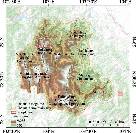
Figure 3 The
named main ridgelines of the Liangshan plateau mountain
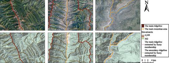
Figure 4 Overlay
effect of the sample areas
5 Discussion and Conclusion
In this paper, the integration extraction method
proposed by Hu et al.[11]
is used to obtain the mountain characteristic elements of the Liangshan plateau
mountain. Next, the mountain characteristic elements were validated with the
ridgelines by the fuzzy membership and the contours. Finally, this data was
manually corrected and named based on Google Earth Map, Google Earth
Topographic Map data, county records, and other related materials. In the results
of this dataset, the corrected ridgelines greatly match with the ridgelines
extracted by the fuzzy membership, and they are mostly on the ridges.
Meanwhile, the boundaries of the mountain are mostly within the rivers and
valleys. The mountain characteristic elements are consistent with the
geomorphological cognition while their spatial location is correct, and the
coupling is great. To sum up, this dataset reflects the overall topographic and
terrain characteristics of the Liangshan plateau mountain. It can provide a
reference for regional geomorphology classification, geographic planning, and
other related applications and research.
Author Contributions
Luo, M. L. designed the algorithms of the dataset.
Hu, J. L. implemented the algorithm and extracted the mountain characteristic
elements. Tang, M. G., Wei, L., Yan, Z. H., and Qin, Z. H. did the data
validation. Hu, J. L., and Luo, M. L. wrote the data paper.
Conflicts of Interest
The authors declare no conflicts of interest.
References
[1]
Hammond, E. H. Analysis of
properties in land form geography: an application to broad-scale land form
mapping [J]. Annals of the Association of
American Geographers, 1964, 54(1): 11?C19.
[2]
Wang, X. P., Wang, Z. H., Fang,
J. Y. Mountain ranges and peaks in China [J]. Biodiversity Science, 2004(1): 206?C212.
[3]
Tang,
G. A., Li, F. Y., Liu, X. J., et al.
Tutorials of Digital Elevation Models [M]. Beijing: Science Press, 2016.
[4]
Xue, K. K., Xiong, Li. Yang., Zhu,
S. J., et al. Extraction of loess
dissected saddle and its terrain analysis by using digital elevation models [J].
Journal of Geo-information Science,
2018, 20(12): 1710?C1720.
[5]
Wood, J. The geomorphological
characterization of Digital Elevation Models [D]. Leicester, UK: University of
Leicester, 1996.
[6]
Gu, L. W., Wang, C., Li, P., et al. Research on mountain top
extraction accuracy based on DEM [J]. Geomatics
and Information Science of Wuhan University, 2016, 41(1): 131?C135.
[7]
Chen, P. P., Zhang, Y. S., Wang,
C., et al. Method of extracting
surface peaks based on DEM [J]. Modern
Surveying and Mapping, 2006(2): 11?C13.
[8]
Menduni,
G., Pagani, A., Rulli, M. C., et al.
A non-conventional watershed partitioning method for semi-distributed
hydrological modelling: the package ALADHYN [J]. Hydrological Processes, 2002, 16(2): 277?C291.
[9]
Mantilla, R., Gupta, V. K. A
GIS numerical framework to study the process basis of scaling statistics in
river networks [J]. IEEE Geoscience and
Remote Sensing Letters, 2005, 2(4): 404?C408.
[10]
Zhou,
Y., Tang, G. A., Xi, Y., et al. A shoulder-lines
connection algorithm using improved Snake Model [J]. Geomatics and Information Science of Wuhan University, 2013, 38(1):
82?C85.
[11]
Hu, J. L., Tang, M. G., Luo, M.
L., et al. The extraction of
characteristic elements of mountain based on DEM [J]. Journal of Geo-information Science, 2020, 22(3): 422?C430.
[12]
Zhou, C. H. A dictionary of Geomorphology
[M]. Beijing: China Water and Power Press, 2006
[13]
Hu, J. L., Luo, M. L., Tang, M.
G., et al. Dataset of mountain
characteristic elements in Liangshan mountain [J/DB/OL].
Digital Journal of Global Change Data Repository,
2021. https://doi.org/10.3974/geodb.2021.
10.09.V1.
https://cstr.escience.org.cn/CSTR:20146.11.2021.10.09.V1.
[14]
GCdataPR Editorial Office.
GCdataPR data sharing policy [OL]. https://doi.org/10.3974/dp.policy.2014.05 (Updated
2017).
[15]
Luo, Y. The Research on macro
mountain lines extraction and its assistant technology [D]. Xi??an: Xi??an University
of Architecture and Technology, 2012.
[16]
Fisher, P., Wood, J., Cheng, T.
Where is Helvellyn? Fuzziness of multi-scale landscape morphometry [J]. Transactions of the Institute of British
Geographers, 2004, 29(1): 106?C128.
[17]
Local Records Compilation
Committee of Ganluo County, Sichuan. Records of Ganluo County [M]. Chengdu: Sichuan
People??s Publishing House, 1996.
[18]
Local Records Compilation
Committee of Ganluo County. Records of Ganluo County [M]. Beijing: China Railway
Publishing House, 2014.
[19]
Records Compilation Committee
of Meigu County, Sichuan. Records of Meigu County [M]. Chengdu: Sichuan People??s
Publishing House, 1997.
[20]
Records Compilation Committee
of Meigu County, Sichuan. Records of Meigu County 1991-2009 [M]. Beijing: China Local Records Publishing, 2017.
[21]
Local
Records Compilation Committee of Mabian Yi Autonomous County. Records of Mabian
Yi Autonomous County [M]. Chengdu: Chengdu University of Science and Technology
Publishing House, 1994.
[22]
Wang, L. J. Records of
Liangshan Yi Autonomous Prefecture [M]. Beijing: China Local Records Publishing,
2002.