|

|
Integrating ICT and Intellectual Property on Geographical Indications Supporting SDGs in Local Places
LIU Chuang
Institute of Geographical Sciences and Natural Resources Research, Chinese Academy of Sciences (IGSNRR/CAS),
Consultant Committee of ICT for the United Nations, China Association for Science and Technology (CCIT/CAST)
|
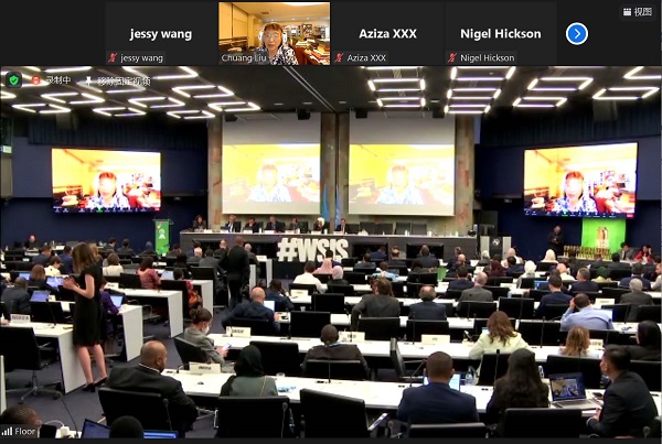
(Introduction: The 2022 World Summit on Information Society Forum of the United Nations (WSIS Forum 2022) was held starting on 15 March, and the final week was from 30 May to 3 June 2022 in Geneva, Switzerland. Prof. LIU Chuang as one of the High Level Policy Forum Panels delivered her policy statement on Integrating ICT and Intellectual Property on Geographical Indications Supporting SDGs in Local Places on 31 May. She indicated that there was critical issue about how to balance environment protection and the socio-economic development in mountain areas, small islands and vulnerable regions responded to the global changes. She called United Nations and all parts of the world to pay real attention to these regions and use ICT, such as big data, internet of things, as well as world data system services to help local people to reach the 2030 SDGs. The full statement is as following)
Excellencies, Ladies, and Gentlemen:
In the implementation of the UN SDGs, Goal 1, Goal 2, Goal 14 and Goal 15 have become crucial parts for the environment protection and socio-economic development. They have been widely implemented in developed regions and most of urban areas. However, they are very prominent due to the infrastructure, natural disasters, less development, lost of education in mountain areas, small islands and critical zones in ecosystem, the contradiction between environmental protection and socio-economic development is a big challenges and it is still difficult to achieve the SDGs in these areas.
From the perspective of geographers, we believe that the performance of world geography at local and regional scales is diverse, and this diversity is particularly prominent in China. Geo-diversity is so full colors in the world, from tropic to cold zones, from humid to arid regions, from continent to ocean, from plains to mountains. Geographical diversity also caused the bio-diversity and product diversity, which are the original ecological characteristics that we often talk about as "geographical genes". Geographical diversity also shows the diversity of local traditional culture and people's living habits and styles.
The Agreement on Trade-Related Aspects of Intellectual Property Rights (TRIPS) is an international legal agreement issued in 1990. It indicated at the Article 22.1 about the geographical indications as "...indications which identify a good as originating in the territory, or a region or locality in that territory, where a given quality, reputation or other characteristic of the good is essentially attributable to its geographical origin.
In 2005, China released “the provisions on the protection of geographical indication” and held a series of international geographical indication Expo. Many countries in Europe, Asia, America, Australia, and Africa have successively issued regulations to protect the geographical indication. Not only, were several agreements about the GI between or among the countries issued. For example, the China-EU agreement on geographical indication was implemented since 2021. In the form of intellectual property, GI has become another part of the product value, that means the geographical indication can obtain market recognition in addition to variety and quality, that is the Reputable Brands.
With a GI brand, can we get the favor of the market and make the local development? Not really in most cases. Geographical products from these regions have a common feature that they are small or not very much. Most of them are distributed in mountainous areas, small island areas, and small ecosystem regions. Many of these products are produced by family farms or small enterprises. Due to geographical restrictions, the total output from such GIs is limited, but they have very special geo-local characteristics. For example, Yanchi Tan Sheep from arid grassland ecosystem of Ningxia region of China, Baoshan coffee, from Hengduan Mountains, Yunnan, burdock from historical Yellow River flood area of Fengxian County, rice from lanshijia village, in the slope of Changbai Mountain, black rice from Yang County, Shaanxi, the Crested Ibis residents, and so on. Recently, the FAO's "one country, one priority product" (OCOP) program also raised this issue. For example, Quinoa from Bhutan in the Himalayas, potatoes from Nepal, ginger from Fiji and breadfruit from Samoa, both are Pacific island countries.
In order for these brand products to be recognized by the market and benefit from local development, the first task is to have the information to be bread communicated. A reliable, full open, traceable and applicable computer network system has become the demand of social consumers and product providers, as well as the need for domestic and international trade and policy makers to formulate policies and timely supervise.
To enhance accessing the local GI information as broad as possible, ICT is an indispensable key. Since January 2021, the Chinese Academy of Sciences coordinated more than 20 organizations to initial a Geographical Indications Environment and Sustainability 2021-2030 Program (GIES), which aims to integrate geographical science, technology and intellectual property into geographical products through ICT and widely disseminate them. At present, 14 cases have been carried out. Our approach is to use the platform services of big data; the Internet of things and the world data center to provide services for the intellectual property, regional ecological environment and local sustainable development through open scientific.
For example, we use the world data center and scientific data publishing to open the case data, open knowledge by publishing papers through the academic journals, and monitor the ecological environment by establishing a local ecological environment monitoring system and combining it with remote sensing satellite images. By the way of Internet of things, QR system, consumers can directly trace the source of products and learn about world geography and foreign cultures using cell phones. As a member of the world data system of the International Council for science, the Global Change Research Data Publishing and Repository (GCdataPR) is one of more than 80 World Data Centers of International Council for Sconces. It plays a role in archiving and permanent preservation, quality control, and opens services for research, education and social sustainable development in the world. It is consisted of two data journals including the Digital Journal of Global Change Data Repository and the Journal of Global Change Data and Discovery.
In the process of practice, we have adopted a multi-stakeholder cooperation methodology in the way of industry, university, research, government, scientific communities, village people and media", and adopted the method of "variety, quality, brand, behavior, and culture" so as to go hand in hand in terms of products, environment, social development, local culture, and people life has become a powerful starting point for Rural Revitalization.
The GIES program is a full open, multi-stakeholder and comprehensive action plan with significant local advantages. In this process, the method of integrating the intellectual property of geographical indications and ICT to escort the local sustainable development is an openly available, sharable and reproducible method. It can be predicted that in the next decade, there will be more and more cases, which will help the mountainous areas, small islands, ecologically critical zones and all geographical indication diversity areas, they will make special contributions to reach to 2030 SDGs.
Thank you!

Professor LIU Chuang Delivered Her Policy Statement at the High Level Policy Forum of WSIS 2022 (online)
.jpg)