Global Change Data Encyclopedia
Channel Islands
Zhang, Y. H. Liu,
C.*
Shi, R. X.
Institute of Geographic Sciences and Natural Resources
Research, Chinese Academy of Sciences, Beijing 100101, China
Keywords: Channel
Islands; Cotentin Peninsula; English Channel; Normandy; data encyclopedia
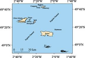
Channel
Islands is located at the entrance to the Gulf of Saint-Malo, in the English
Channel, west of the Cotentin peninsula of France, 130 km south of the British
Isles and 17 km from Granville. Chausey forms part of the Channel Islands under
French Jurisdiction. It??s geo-location is 48??51??59??N?C49??44??20??N,
2??42??12??W?C1??43??51??W[1‒3] (Figure 1, 2).
|
|
|
|
Figure 1 Map of
Channel Island
(.shp format)
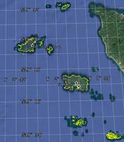
|
Figure 2 Map of Channel Islands
(.kmz
format)
|
Channel Islands comprise four main islands,
Jersey, Guernsey, Alderney, and Sark[4].
They are 730 islands, islets, rocks and reefs with area bigger than 70 m2.
The Jersey is the largest island, about 20 km west of the Cotentin peninsula
and about 30 km south of the Guernsey. Its area is 121.63 km2 and
coastline length is 100.25 km. Around it are two uninhabited isles, one of
which is Minquiers southern extremity of the Channel Islands, and the other is
Ecrehous eastern extremity of the Channel Islands. The second largest of the
Channel islands is Guernsey with area of 65.59 km2 and coastline of
101.21 km, western of the Channels. Alderney is located north of the Channel
Islands and separated from the Normandy coast by the swift Race of Alderney.
Sark lies in the middle of the Channel Island, about 11 km east of Guernsey and
consists of two components, Great Sark and Little Sark. Other small islands
include Herm, Brecqhou, Lihou Island, Burhou, Jethou, Martresse, Casquets,
Marmotiere, Ortac, etc. (Table 1). The total area of the Channel islands is 216.82
km² and the total coastline length is 534.94 km.
Table
1 Geolocation, area
and coastline of main islands of the Channel Islands
|
Name of Island
|
Geolocation
|
Centroid
of island
|
Area (km2)
|
Coastline (km)
|
|
Jersey
|
49??9??45??N?C49??15??44??N, 2??15??17??W?C2??0??38??W
|
49??12??50??N, 2??7??59??W
|
121.63
|
100.25
|
|
Guernsey
|
49??24??59??N?C49??30??35??N, 2??40??32??W?C2??30??4??W
|
49??27??23??N, 2??34??46??W
|
65.59
|
101.21
|
|
Alderney
|
49??42??3??N?C49??43??58??N, 2??14??4??W?C2??9??30??W
|
49??42??56??N, 2??11??58??W
|
8.68
|
26.19
|
|
Sark
|
49??24??27??N?C49??27??8??N, 2??22??60??W?C2??20??31??W
|
49??25??45??N, 2??21??47??W
|
5.56
|
22.47
|
|
Herm
|
49??27??46??N?C49??29??1??N, 2??27??31??W?C2??26??27??W
|
49??28??23??N, 2??26??59??W
|
1.40
|
6.31
|
|
Brecqhou
|
49??25??42??N?C49??26??7??N, 2??23??45??W?C2??22??53??W
|
49??25??56??N, 2??23??17??W
|
0.38
|
3.88
|
|
Lihou Island
|
49??27??27??N?C49??27??50??N, 2??40??23??W?C2??39??49??W
|
49??27??40??N, 2??40??4??W
|
0.24
|
2.93
|
|
Burhou
|
49??43??43??N?C49??43??60??N, 2??15??28??W?C2??14??47??W
|
49??43??51??N, 2??15??8??W
|
0.22
|
2.79
|
|
Jethou
|
49??27??20??N?C49??27??43??N, 2??27??57??W?C2??27??32??W
|
49??27??31??N, 2??27??45??W
|
0.22
|
2.04
|
|
Maitresse
|
49??17??0??N?C49??17??13??N, 1??55??39??W?C1??55??30??W
|
49??17??7??N, 1??55??34??W
|
0.04
|
0.95
|
|
Casquets
|
49??43??15??N?C49??43??22??N, 2??22??44??W?C2??22??30??W
|
49??43??19??N, 2??22??37??W
|
0.03
|
0.98
|
|
Marmotiere
|
49??17??23??N?C49??17??34??N, 1??55??54??W?C1??55??38??W
|
49??17??29??N, 1??55??45??W
|
0.03
|
0.97
|
|
Ortac
|
49??43??22??N?C49??43??24??N, 2??17??28??W?C2??17??25??W
|
49??43??23??N, 2??17??26??W
|
0.002
|
0.17
|
The dataset was
developed based on Google Earth and related maps and references[2‒3].
The dataset is consisted of 16 data files and archived in the .kmz and .shp[5]
data formats with the data size of 3.69 MB (Compressed to 1.56 MB in two
files).
References
[1]
Channel
Islands [OL]. Encyclopedia Britannica, Encyclopedia Britannica Inc., 13 Mar.
2019. https://www. britannica.com/place/Channel-Islands-English-Channel.
[2]
World Map
Atlas: United Kingdom Atlas [M]. Beijing: Sino Maps Press, 2007.
[3]
Liu, C.,
Shi, R. X., Zhang, Y. H., et al.
Global multiple scale shorelines dataset based on Google Earth images (2015) [DB/OL].
Global Change Data Repository, 2019. DOI: 10.3974/geodb.2019.04.13.V1.
[4]
Zhang, Y.
H., Liu, C., Shi, R. X. Chanel Islands [DB/OL]. Global Change Data Repository, 2020. DOI:
10.3974/geodb.2020.02.04.V1.
Data Computing Environment
[5]
ESRI.
ArcGIS campus license of Institute of Geographic Sciences and Natural Resources
Research, Chinese Academy of Sciences.
URL for Data Downloading
http://www.geodoi.ac.cn/WebEn/doi.aspx?Id=1426.
Or search
through: http://www.geodoi.ac.cn.