Boundary Data of the Koshi River Basin
Zhang, Y. L.1,2 Wu, X.1 Gao, J. G.3 Li, B. Y.1
1. Institute of Geographic Sciences and Natural Resources
Research (IGSNRR), Chinese Academy of Sciences, Beijing 100101, China;
2. University of Chinese Academy of Sciences, Beijing
100049, China;
3. Texas A & M University, Texas 76502, USA
Keywords: Koshi River basin; boundary; Mount
Xixabangma; Mount Qomolangma; Pumqu, Yairuzangbo; Tibet Autonomous Region
DOI: https://doi.org/10.3974/geodp.2022.04.17
CSTR: https://cstr.escience.org.cn/CSTR:20146.14.2022.04.17
Dataset Availability Statement:
The dataset
supporting this paper was published and is accessible through the Digital Journal of
Global Change Data Repository at: https://doi.org/10.3974/geodb.2022.10.03.V1 or https://cstr.escience.org.cn/CSTR:20146.11.2022.10.03.V1.
The Koshi River originates from the Dasuopu Glacier,
which located on the north slope of Xixabangma in the central Himalayas. It
crosses the entire mountain range from the north and eventually reaches the
Ganges plain in the south. The Koshi River flows through China, Nepal, and
India, making it a crucial tributary of the Ganges River and a significant
transboundary river in South Asia. The drainage system of Koshi River basin (KFB) is
primarily composed of three
tributaries: Sun Koshi River
in the west branch, Arun River in the north branch and Tamor River in the east
branch[1?C4]. The Sun Koshi River originates
in Tibet, China (In China it is known as Yairuzangbo),
and with a length of 366 km. Tamor River originates from Mount Kanchenjunga,
and with a length of 191 km. The middle and upper reaches of the Arun River are
called Pumqu in China and originate from Dasuopu Glacier on the north slope of
Mount Xixabangma. The length of the Arun River is 523 km, and the length of the
Koshi River basin is 801 km. The three rivers join to form the Koshi River near
Dhankuta and finally join the Ganges at Katihar in India. The Koshi River rises
north to the Laguigangri mountains, South to the junction of the Koshi River on
the Ganges plain, West to the Kathmandu valley, east to the New Garira
Mountains[2?C4]. The Koshi River basin located in 85??01ʹE?C88??57ʹE, 25??20ʹN?C29??09ʹN, spans
three countries: China, Nepal and India. The KRB has a total area of 87,723 km2
and a circumference of 1,985 km, the northern part located in Tibet autonomous
region of China, covering an area of 29,387 km2, accounting for
33.50% of the total basin area; the central part located in Nepal, covering an
area of 39,494 km2, accounting for 45.02% of the total basin area;
the southern part located in India, covering an area of 18,841 km2,
accounting for 21.48% of the total basin area.
The Koshi River basin boasts the world??s greatest elevation drop. It
is home to six of the world??s fourteen highest peaks above 8,000 m[2?C4],
including Mount Qomolangma (8,848.86 m),
Mount Kanchenjunga (8,586 m) and Mount Lhotse (8,516 m), etc. Among them, Qomolangma is the
highest peakin the basin, while the lowest peak liesat the confluence of the Koshi
and Ganges rivers, with an elevation of only 33 m. The basin experiences an elevation
drop of 8,810 m, resulting in complete vertical natural zones, varieties of landscape
types, land use forms are abundant and significant regional differences[4?C6].
The Koshi River basin
in China comprises mainly the Pumqu basin and Yairuzangbo basin. Langqiang Co,
situated in the rain shadow zone of The Himalayas, as well as Baikuimai Co and
Cuomuzhelin lake, are primarily fed by precipitation, and the three lakes were
originally part of Pumqu basin. As the climate of ??rain shadow zone?? became dry
and the precipitation decreased, the lake shrank and the lake surface decreased,
and finally closed into three independent inland basins, Langqiang Co basin
(with an area of 71 km2, a circumference of 40 km), Baikuimai Co
basin (71 km2, 38 km) and Cuomuzhelin basin (1,067 km2,
181 km). Their original outflow rivers were separated by accumulation plains.
Their original outflow rivers are separated by an accumulation plain with a
residual dry channel, which can be regarded as a product of climate change and
a part of the Koshi River basin.
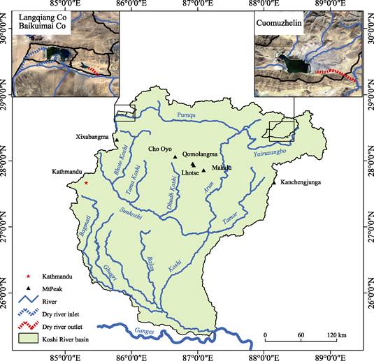
Figure 1 Map of Koshi River
basin
The KRB involves 5
counties in China??s Tibet autonomous region, 3 provinces with 27 districts in
Nepal, and 1 state 6 zones with 14 counties in India. The list of administrative
regions in the KRB was shown in Table 1.
Table 1 Administrative regions of Weihe River basin
|
Country
|
State/Province
|
Zone/ City
|
County /District
|
Area (km2)
|
|
China
|
Tibet autonomous region
|
Rikaze city
|
Dingjie county, Nyalam county, Kamba county and Sa??gya country (5
counties)
|
29,387
|
|
Nepal
|
Province NO.1
|
|
Taplejung, Panchthar, Sankhuwashava, Bhojpur, Tehrathum, Dhankuta, Sunsari,
Solukhumbu, Khotang, Okhaldhunga, Udayapur
|
39,495
|
|
Province NO.2
|
|
Saptari, Siraha, Dhanusha, Mahottari, Sarlahi, Rautahat, Bara
|
|
Province NO.3
|
|
Ramechhap, Sindhuli, Sindhupalchowk, Lalitpur, Kathmandu, Bhaktapur, Kabhrepalanchow,
Makawanpur, Dolakha
|
|
Total (Nepal)
|
3 provinces
|
|
27 districts
|
|
India
|
Bihar state
|
Tirhut zone
|
Muzaffarpur, Purba Champaran,
Sitamarhi, Sheohar
|
18,823
|
|
Darbhanga zone
|
Darbhanga, Madhubani, Samastipur
|
|
Munger zone
|
Begusarai, Khagaria
|
|
Purnia zone
|
Purnia
|
|
Kosi zone
|
Saharsa
Madhepura
|
|
Bhagalpur zone
|
Bhagalpur
|
|
Total (India)
|
1 state
|
6 zones
|
14 counties
|
*From references [7, 8].
The boundary
data of the KRB was developed based on ASTER-DEM with a precision of 30 m??30 m and Google Earth image to interpret the distribution of river
network, the river network and watershed are generated in ArcGIS software to
extract the preliminary results. Then, the Koshi River basin boundary was
manually revised at the scale of 1:100,000 by referring to Google Earth image
with 10 m??10 m spatial resolution and DEM data. The boundary of the Koshi
River basin is not include the three inland basin of Langqiang Co basin,
Baikuimai Co basin and Cuomuzhelin basin when used, the actual area of Koshi River
basin is 86,539 km2 and a circumference of 2,134 km. The data is
archived in both .kmz and .shp formats with the compressed data size of 22.7 MB[9].
References
[1]
Deng,
W., Zhang, Y. L., et al. Resource,
Environment and Development of Koshi River Bsin [M]. Chengdu: Sichuan Science
and Technology Press, 2014.
[2]
Zhang,
Y. L., Yao, Z. J., Liu, L. S., Wu, X., et
al. Study on land use and land cover change and soil erosion in the Koshi
River basin (Final report) [R]. Beijing: Institute of Geographic Sciences and
Natural Resources Research Chinese Academy of Sciences (CAS), February 28,
2016.
[3]
Wu,
X., Gao, J. G., Zhang, Y. L., et al. Land cover status in the Koshi River basin, central Himalayas
[J]. Journal of Resources and Ecology,
2017, 8(1): 10?C19.
[4]
Wu,
X. Analysis on horizontal and altitudinal distribution and change of land cover
in Koshi River basin of the central Himalayas [D]. Beijing: University of
Chinese Academy of Sciences, 2017.
[5]
Zhang,
Y. L., Gao, J. G., Liu, L. S., et al. NDVI-based vegetation changes and
their response to climate change from 1982 to 2011: a case study in the Koshi
River basin in the middle Himalayans [J]. Global
and Planetary Change, 2013, 108: 139?C148.
[6]
Gao,
J. G. Land cover change and its relationship with climate change in Koshi River
basin of the central Himalaya [D]. Beijing: University of Chinese Academy of Sciences,
2012.
[7]
Committee of the Chronicles Of
Nations, Chinese Academy of Social Sciences, Wang, H. W. New edition of
Chronicles of Nations: Nepal [M]. Beijing:
Social Sciences Academic Press, 2015.
[8]
Committee
of the Chronicles Of Nations, Chinese Academy of Social Sciences, Ren, J., Li,
L. New edition of Chronicles of Nations: India [M]. Beijing: Social Sciences Academic Press, 2016.
[9]
Zhang, Y. L., Wu, X., Gao, J. G., et al. Koshi River basin [J/DB/OL]. Digital Journal of Global Change Data Repository, 2022.
https://doi.org/10.3974/geodb.2022.10.03.V1.
https://cstr.escience.org.cn/CSTR:20146.11. 2022.10.03.V1.