Spatial Dataset of the Islands and Reefs Occupied by Vietnam in the South China Sea
Tang, M.
Collaborative Innovation Center of South China Sea Studies, Nanjing University, Nanjing 210093, China
Abstract: Spatial and geographical information of 29 islands and reefs (including 4 islands, 15 reefs, 3 sandbanks, 5 shoals and 2 underwater shoals) in South China Sea occupied by Vietnam during 1972-1998 was collected in the dataset. In which, there are 9 islands during the 1970s (Hongxiu Dao, Anbo Shazhou, Dunqian Shazhou, Jinghong Dao, Nanwei Dao, Nanzi Dao, Bisheng Jiao, Ranqing Shazhou, Zhong Jiao), 13 during the 1980s (Bolan Jiao, Daxian Jiao, Dong Jiao, Guihan Jiao, Liumen Jiao, Nailuo Jiao, Nanhua Jiao, Riji Jiao, Wumie Jiao, Xi Jiao, Bo Jiao, Qiong Jiao, Wanan Jiao), and 7 during the 1990s (Guangya Jiao, Pengbobao Jiao, Renjun Tan, Lizhun Tan, Xiwei Tan, Aonan Ansha, Jindun Ansha). The dataset is archived in .shp and .kmz formats with the data size of 6.5 KB after compression.
Keywords: Nansha Islands; Vietnam; islands and reefs; occupy; 1973-1998
1 Introduction
The Nansha Islands located in the south-eastern South China Sea (SCS), including Xiongnan Tan (11°57′00″N, 116°40′00″E) in the north, Zengmu Ansha (03°57′44″N-03°59′00″N, 112°16′25″E-112°17′10″E) in the south, Wanan Tan (07°32′00″N, 109°30′00″E) in the west and Haima Tan (10°43′00″N-10°51′00″N, 117°44′00″E-117°50′00″E) in the east, and covering an area of 823,000 km2. Totally, there are 287 islands and channels distributed along the N-S three-steps continental slope[1–2].
Chinese people have a long history using the SCS as a fishing ground and as an important pass way to other countries. Marine products from the SCS were found in historical records since the Three-Kingdoms period (220-280 A.D.). Trade routes between Southeast Asian countries gradually emerged during the Han Dynasty (202 B.C. to 220 A.D.) by using the SCS. More important shipping routes were developed across the SCS during the Jin to Tang Dynasty (226-907 A.D.), as the rise in the Buddhist culture increased the demand to import Indian scriptures by sea. New trade routes to Southeast Asia, India, and Africa were opened up through the SCS as a result of Zheng He’s seven voyages (1405-1433 A.D.) in the Ming Dynasty.
The modern geological surveys and studies on SCS started in the1980s[3–4], mainly focused on the natural geographic environment[5–6], coral reef geomorphology[7–9], back-arc basin geological history[10–11], semi-quantitative analysis of economic, political, and natural value of Nansha Islands[12], and engineering geology studies[13]. Calculation of strategic value and analysis of the development potential were based on geographic parameters such as location, size, and water depth. Spatial interpolation, reclassification and grid calculation were operated in ArcGIS10.1. The results provide rational support for asserting maritime rights and interests and solving the South China Sea dispute[14].
2 Metadata of Dataset
Table 1 summaries the metadata of the spatial distribution dataset of the islands and reefs occupied by Vietnam in South China Sea, including: dataset full name, dataset short name, author, study area, publish and shared service platform and policy, etc.
Table 1 Metadata summary of spatial distribution dataset of the islands and reefs occupied by Vietnam in South China Sea[15]
|
Item
|
Description
|
|
Dataset full name
|
Spatial dataset of the islands and reefs occupied by Vietnam in the South China Sea
|
|
Dataset short name
|
29IslandsReefsInNanshaIslands(1973-1998)
|
|
Authors
|
Meng, T. M-4463-2016, Collaborative Innovation Center of South China Sea Studies, Nanjing University, tame159@qq.com
|
|
Geographical region
|
South China Sea (5°N-12°N, 109°E-114°E)
|
|
Data Time
|
1973-1998
|
|
Data Formats
|
.kmz, .shp
|
|
Data Size
|
.kmz (3.60 KB), .shp (2.90 KB) (after compression)
|
|
Data files
|
Data stored as .shp files in the dataset are correlated to .kmz format in Google Earth
|
|
Foundation(s)
|
Chinese Academy of Sciences (2016ZWH005A-005)
|
|
Data publisher
|
Global Change Research Data Publishing and Repository, http://www.geodoi.ac.cn
|
|
Address
|
No. 11A, Datun Road, Chaoyang District, Beijing 100101, China
|
|
Data sharing policy
|
Data from the Global Change Research Data Publishing & Repository includes metadata, datasets (data products), and publications (in this case, in the Journal of Global Change Data & Discovery). Data sharing policy includes: (1) Data are openly available and can be free downloaded via the Internet; (2) End users are encouraged to use Data subject to citation; (3) Users, who are by definition also value-added service providers, are welcome to redistribute Data subject to written permission from the GCdataPR Editorial Office and the issuance of a Data redistribution license, and; (4) If Data are used to compile new datasets, the ‘ten percent principal’ should be followed such that Data records utilized should not surpass 10% of the new dataset contents, while sources should be clearly noted in suitable places in the new dataset16]
|
3 Methods
Sea bed morphology was based on interpolation of water depths and isobaths extracted from 11 charts (Table 2) by ArcGIS 10.1, in Mercator projection and CGCS 2000 coordinate system. Precise proportion of islands and reefs, and occupied date were from the literature[12–13].
Table 2 Information on maritime charts in this study[14]
|
Chart ID
|
Publication date
|
Projection
|
Scale
|
Chart name
|
|
18100
|
Jan. 2013
|
Mercator
projection
|
1??250,000 (12°)
|
Shuangziqun Jiao to Zhenhequn Jiao
|
|
18102
|
Jun. 2012
|
Wanan Tan to Guangya Tan
|
|
18103
|
Jan. 2013
|
Huanglu Jiao to Nanan Jiao
|
|
18104
|
Mar. 2013
|
Zengmu Ansha and Approaches
|
|
18200
|
Jan. 2013
|
Liyue Tan
|
|
18300
|
Feb. 2013
|
Yongshu Jiao to Yinqing Qunjiao
|
|
18400
|
Mar. 2013
|
Zhenghe Qunjiao to Yongshu Jiao
|
|
18500
|
Feb. 2013
|
Nanfang Qiantan to Haikou Jiao
|
|
18600
|
Dec. 2012
|
Yinqing Qunjiao to Nanwei Tan
|
|
18700
|
Feb. 2013
|
Wumie Jiao to Huanglu Jiao
|
|
18800
|
Jan. 2013
|
Haikou Jiao to Yuya Ansha
|
4 Results and Verification
4.1 Results
(1) Spatial Distribution
This study covered the area ranging from 7°N-12°N and 109°E-115°E, containing 29 islands and reefs (4 islands, 15 reefs, 3 sandbanks, 5 shoals, and 2 underwater shoals).
Figure 1 Location of islands and reefs occupied by Vietnam in the South China Sea[15]
(2) Occupation Process
Islands and sandbanks with good living conditions were occupied first. Reefs and shoals were occupied later by constructing simple blockhouses during 1988-1990, and underwater shoals were the last to be occupied (Table 3).
Table 3 Types and date of occupation of islands and reefs[14]
|
Name
|
Type
|
Longitude (E)
|
Latitude (N)
|
Year of
occupied
|
|
Hongxiu Dao
|
Island
|
114°21′29″
|
10°10′59″
|
1973
|
|
Nanzi Dao
|
Island
|
114°19′19″
|
11°25′30″
|
1973
|
|
Dunqian Shazhou
|
Sandbank
|
114°28′0″
|
10°22′59″
|
1973
|
|
Jinghong Dao
|
Island
|
114°19′59″
|
9°52′59″
|
1973
|
|
Nanwei Dao
|
Island
|
111°54′39″
|
8°39′0″
|
1973
|
|
Anbo Shazhou
|
Sandbank
|
112°54′42″
|
7°52′12″
|
1973
|
|
Ranqing Shazhou
|
Sandbank
|
114°34′0″
|
9°54′0″
|
1978
|
|
Zhong Jiao
|
Reef
|
112°22′0″
|
8°55′59″
|
1978
|
|
Bisheng Jiao
|
Reef
|
113°42′0″
|
8°58′0″
|
1978
|
|
Nailuo Jiao
|
Reef
|
114°17′26″
|
11°23′9″
|
1988
|
|
Daxian Jiao
|
Reef
|
113°52′30″
|
10°4′0″
|
1988
|
|
Bolan Jiao
|
Reef
|
114°34′0″
|
10°24′39″
|
1988
|
|
Guihan Jiao
|
Reef
|
114°15′0″
|
9°45′0″
|
1988
|
|
Dong Jiao
|
Reef
|
112°36′29″
|
8°49′0″
|
1988
|
|
Xi Jiao
|
Reef
|
112°14′30″
|
8°51′0″
|
1988
|
|
Riji Jiao
|
Reef
|
111°40′29″
|
8°39′29″
|
1988
|
|
Liumen Jiao
|
Reef
|
113°58′29″
|
8°48′0″
|
1988
|
|
Nanhua Jiao
|
Reef
|
114°10′59″
|
8°43′0″
|
1988
|
|
Wumie Jiao
|
Reef
|
114°39′29″
|
8°51′29″
|
1988
|
|
Qiong Jiao
|
Reef
|
114°22′0″
|
9°46′0″
|
1989
|
|
Wanan Tan
|
Shoal
|
109°46′30″
|
7°30′0″
|
1990
|
|
Bo Jiao
|
Reef
|
113°19′0″
|
8°5′30″
|
1987
|
|
Guangya Tan
|
Shoal
|
110°31′0″
|
8°7′59″
|
1990
|
|
Renjun Tan
|
Shoal
|
110°36′29″
|
8°0′0″
|
1990
|
|
Pengbobao Jiao
|
Reef
|
111°44′30″
|
7°56′30″
|
1989
|
|
Lizhun Tan
|
Shoal
|
110°28′29″
|
7°48′0″
|
1991
|
|
Xiwei Tan
|
Shoal
|
109°58′0″
|
7°52′0″
|
1991
|
|
Jindun Ansha
|
Shoal (underwater)
|
111°31′59″
|
7°31′59″
|
1998
|
|
Aonan Ansha
|
Shoal (underwater)
|
111°45′0″
|
7°42′0″
|
1998
|
4.2 Spatial Verification with Google Earth Image
The correlation between this dataset and Google Earth is shown in Figure 2. The data points are shown as yellow pins overlapping with the Google Earth image.
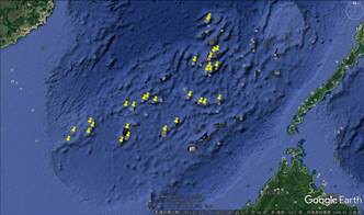
Figure 2 Data overlaid on Google Earth image
References
[1] Zhao, H. T. Physical Geography of Nansha Islands [M]. Beijing: Science Press, 1996: 35-60.
[2] Wang, Y. China Marine Geography [M]. Beijing: Science Press, 1996: 74-87.
[3] Chinese Academy of Sciences. Report on the comprehensive survey of Spratly Islands and its adjacent sea area (Vol. 1) [R]. Beijing: Science Press, 1989: 11-106.
[4] Chinese Academy of Sciences. Report on the Comprehensive Survey of Spratly Islands and its adjacent sea area (Vol. 2) [R]. Beijing: Science Press, 1989: 15-53.
[5] Chen, S. J. The natural survey of Spratly Islands [J]. Marine Science Bulletin, 1982(1): 52-58.
[6] Zhao, H. T. Integrated physical geographical regionalization of the Nansha Islands [J]. Tropical Geography, 1982, 16(4): 304-309.
[7] Zhao, H. T, Song, C. J., Zhu, Y. Z. Geomorphic and modern sedimentary features of coral reefs in the hinterland of ‘dangerous ground’, Nansha Islands [J]. Quaternary Sciences, 1992, 12(4): 368-377.
[8] Zhao, H. T., Song, C. J., Lu, B. A preliminary exposition of coral reef engineering geology [J]. Journal of Engineering Geology, 1996, 4(1): 86-90.
[9] Zhao, H. T., Wang, L. R., Song, C. J. Geomorphological model of coral reefs in the South China Sea [J]. Acta Oceanologica Sinica, 2014, 36(9): 112-120.
[10] Zhao, H. T., Zhu, Y. Z., Sha, Q. A. A study on the quaternary system of Yongshu Reef in Nansha Islands. Tropical Geography, 1994, 14(2): 97-104.
[11] Zhao, H. T., Wen, X. S., Sun, Z. X., et al. Regional geology, geomorphology and paleooceanography of the Nansha Islands [J]. Tropical Geography, 1995, 15(2): 128-137.
[12] Zhang, H. X. Strategic value evaluation of Nansha Islands, South China Sea [D]. Nanjing: Nanjing University, 2014: 25-157.
[13] Wang, Z. X. Study on engineering geological properties of coral reefs and feasibility of large project construction on Nansha Islands [D]. Wuhan: Institute of rock and soil mechanics, Chinese Academy of Sciences, 2008: 25-150.
[14] Tang, M. Spatial distribution characteristic and strategic situation of the islands and reefs Invaded by Vietnam in the Chinese Nansha Islands [J]. Tropical Geography, 2015, 35(5): 739-744.
[15] Tang, M. Spatial dataset of the islands and reefs occupied by Vietnam in the South China Sea [DB/OL]. Global Change Research Data Publishing & Repository, 2016. DOI: 10.3974/geodb.2016.02.19.V1.
[16] GCdataPR Editorial Office. GCdataPR data sharing policy [OL]. DOI: 10.3974/dp.policy.2014.05 (Updated 2017).