Global Change Data Encyclopedia
Prince Edward Island
Hu, K.1 Han, N.
L.1* Liu, C.2* Shi, R. X.2
1. Department
of Land Resources Management, School of Politics and Public Administration,
Hainan University, Haikou 570100, China;
2. Institute
of Geographic Sciences and Natural Resources Research, Chinese Academy of
Sciences, Beijing 100101, China
Keywords: Prince Edward Island; Canada; 2015; data
encyclopedia
Dataset Availability Statement:
The dataset
supporting this paper was published and is accessible through the Digital Journal of Global Change Data
Repository at: https://doi.org/10.3974/geodb.2020.05.03.V1.
|
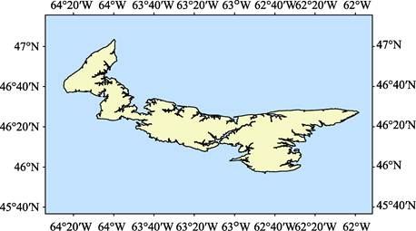
Figure 1 Map of the Prince Edward Island (.shp
format)
|
Prince
Edward Island is located in Southeastern Canada, North America, South of St. Lawrence??s
Bay, the Northumberland Strait to the southwest,
is 12.67 km away from the con-
tinent
of North America, 51.52 km east of Cape Breton Island. Its geo-
location is 45??56¢54²N‒47??03¢32²N, 64??24¢50²W‒61??58¢15²W[1‒3]. The total area of Prince Edward Island calculated
based on the Albers projection is 5,676.45 km2, and the coastline of
the island calculated based on the Lambert projection is 2,282.51 km (Figure 1-2).
Prince Edward
Island was originally discovered by the explorer Jacques Cartier while sailing
along the coast in 1534 and named it Saint Jean, In 1799, Parliament approved
the name of Prince Edward Island after King George III??s fourth son, Prince
Edward, Duke of Kent and Strathson. In terms of administrative divisions,
Prince Edward Island is part of the Prince Edward Province of Canada. Prince
Edward province is Canada??s smallest and most densely populated province. It is
also the country??s most populous province in rural areas. It is connected to
neighboring New Brunswick by the Federal Bridge. Its capital, Charlottetown, is
located in the south-central part of Prince Edward Island. The main cities on
the island are Charlottetown and Sumerside. There is an airport near the two
cities.
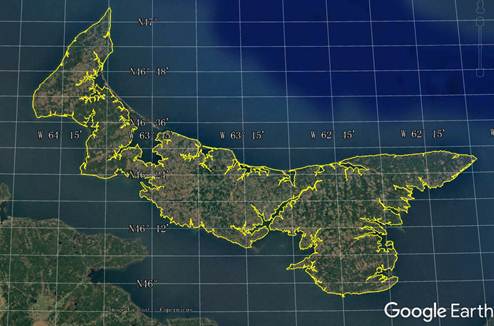
Figure 2 Map of the Prince Edward Island (.kmz
format)
Prince Edward
Island has a temperate continental climate. The island climate is affected by
the ocean. It has longer winters and warmer and humid summers. The climate is
milder than that of continental Canada. There is no fog throughout the year,
and the temperature remains around 20 ??C. The
annual rainfall on the island is about 1,125.8 mm, and the annual snowfall is
about 318.2 mm. The soil of Prince Edward Island contains a lot of iron oxide,
the ground is reddish brown, the soil is fertile. The fertile soil and the
temperate growing season all contribute to the development of the island??s agriculture.
At the same time, there are many sandy beaches on the north shore of Prince
Edward Island, forming numerous natural bathing beaches. The warm water and
beautiful scenery also promote the development of tourism. In general, the
island extends northwest-southeast, resembling a crescent moon lying across. It
is divided into three almost equal parts: Kings, Queens, and Prince. There are
a small part of hilly land in the east and middle of the island, and the height
of other places does not exceed 500 m above sea level[4‒5].
This dataset is developed based on the
global multi-scale sea, land (island) shoreline data set of Google Earth remote
sensing images (2015), referenced with relevant Canadian maps. The data set
consists of 24 data files, archived in .kmz and .shp data formats, with a data size
of 5.38 MB (compressed into 1 file, 3.11 MB)
References
[1]
Sino Maps Press. World Map
Atlas: Canada Atlas [M]. Beijing: Sino Maps Press, 2019.
[2]
Hu, K., Han, N. L., Liu, C., et al.
Prince Edward Island [J/DB/OL]. Digital
Journal of Global Change Data Repository, 2020. https://doi.org/10.3974/geodb.2020.05.03.V1.
[3]
Liu, C., Shi, R. X., Zhang, Y.
H., et al. Global multiple scale
shorelines dataset based on Google Earth images (2015) [J/DB/OL]. Digital Journal of Global Change Data
Repository, 2019. https://doi.org/10.3974/
geodb.2019.04.13.V1.
[4]
Prince Edward Island [OL].
Encyclopedia Britannica. February 07, 2019. https://www.britannica. com/place/Prince-Edward-Island.
[5]
Holman,
H. T., Robb, A. Prince Edward Island [M]. The Canadian Encyclopedia, Historica
Canada, 18 December 2019. https://www.thecanadianencyclopedia.ca/en/article/
prince-edward-island. 10 November 2020.