Global Change Data Encyclopedia
Andaman Islands, India
Shen, Y.1 Liu, C.1*
Shi, R. X.1 Chen,
L. J.2
1. Institute of Geographic Sciences and Natural Resources
Research, Chinese Academy of Sciences, Beijing 100101, China;
2. National Geomatics Center of China, Beijing 100830,
China
Keywords: Andaman Islands; Andaman and Nicobar
Islands; Bay of Bengal; Indian Ocean; India; data encyclopedia
|

Figure
1
Map of Andaman Islands
(.kmz format)
|
Andaman Islands is the main part of the Andaman
and Nicobar Islands. It belongs to the Indian Union Territory of Andaman and
Nicobar Islands, and its geo-location is 10??30??39??N?C13??40??36??N, 92??11??55??E?C94??16?? 38??E[1]. It is located between the Bay of Bengal and the Andaman Sea (Figure
1). It is separated from Coco Islands[2] by Coco Chanel at its
north, and from Nicobar Islands[3] by Ten Degree Chanel at its
south. The Andaman Islands consists of Great Andaman Archipelago[4],
Little Andaman Group[5], Ritchie??s Archipelago[6], East
Volcano Islands[7] and Sentinel Islands[8] (Figure 2),
with a total of 211 islands (islets, rocks)[1]. The total area of
the Andaman Islands is 5,787.79 km2, and the coastline is 2,878.77
km.
Great Andaman Archipelago is the main part
of Andaman Islands, and is the largest Archipelago in Andaman Islands. Its
geo-location is 11??8??26??N?C13??40??36??N,
92??30??48??E?C 93??6??14??E. It lies in the east of Bay of Bengal and in the
west of the Andaman Sea, East
Volcano
Islands, and Ritchie??s Archipelago. It is separated 40 km away from Coco Islands
by
|
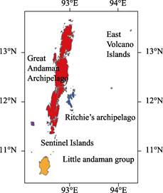
Figure 2 Visualization map of Andaman Islands
(.shp format)
|
the
Coco Channel at its northeast. Great Andaman Archipelago is consisted of North
Andaman Island[9], Cleugh Passage Group[10], Aerial Bay Islands[11],
Stewart Sound Group[12], Interview Group[13], Middle
Andaman Island[14], Baratang Island[15], East Baratang
Group[16], West Baratang Group[17], South Andaman Island[18],
Napier Bay Islands[19], Defence Islands[20], Port Blair Islands[21]
and Rutland Archipelago[22], with a total of 175 islands (islets, rocks).
Great Andaman Archipelago is in a long and narrow shape, from the Landfall
Island of the Cleugh Passage Group at the north end to the West Sister Island
of the Rutland Archipelago at the south end. It is 282 km from north to south
and 40 km from west to east. The
total area of Great Andaman Archipelago is 4,774.10 km2, and the
coastline is 2,325.16 km (Table 1).
Table 1 Geo-location, area, and coastline of
main islands of the Great
Andaman Archipelago
|
Name of the islands
|
Name of the island
|
Center location of
the island
|
Area (km2)
|
Coastline (km)
|
|
Cleugh Passage
Group
|
West Island
|
13??35??19??N, 92??53??33??E
|
2.71
|
8.31
|
|
East Island
|
13??38??20??N, 93??3??13??E
|
3.18
|
10.73
|
|
Landfall Island
|
13??39??11??N, 93??0??19??E
|
16.56
|
24.18
|
|
Others
|
|
7.83
|
28.04
|
|
Subtotal
|
|
30.28
|
71.26
|
|
Aerial Bay Islands
|
Excelsior Island
|
13??26??1??N, 93??5??59??E
|
0.38
|
3.18
|
|
Smith Island
|
13??20??36??N, 93??3??40??E
|
20.26
|
29.23
|
|
Table Island
|
13??24??52??N, 93??5??29??E
|
0.71
|
3.92
|
|
|
Others
|
|
5.39
|
30.34
|
|
|
Subtotal
|
|
24.94
|
66.67
|
|
Interview Group
|
Anderson Island
|
12??46??27??N, 92??42??34??E
|
15.59
|
36.14
|
|
Interview Island
|
12??53??36??N, 92??41??15??E
|
100.08
|
76.20
|
|
|
Murga Island
|
12??54??15??N, 92??47??16??E
|
3.71
|
11.43
|
|
|
South Reef Island
|
12??46??13??N, 92??39??16??E
|
0.39
|
2.77
|
|
|
Others
|
|
22.60
|
97.85
|
|
|
Subtotal
|
|
142.37
|
224.39
|
|
Stewart Sound
Group
|
Aves Island
|
12??54??57??N, 92??56??3??E
|
0.23
|
2.02
|
|
Curlew Island
|
13??0??13??N, 92??54??41??E
|
0.04
|
0.83
|
|
|
Karlo Island
|
12??56??10??N, 92??53??28??E
|
0.08
|
1.25
|
|
|
Sound Island
|
12??57??55??N, 92??58??36??E
|
13.14
|
37.83
|
|
|
Stewart Island
|
13??0??42??N, 92??55??48??E
|
7.04
|
13.26
|
|
|
Others
|
|
4.53
|
24.4
|
|
|
Subtotal
|
|
25.06
|
79.59
|
(To be continued
on the next page)
(Continued)
|
Name of the islands
|
Name of the island
|
Center location of
the island
|
Area (km2)
|
Coastline (km)
|
|
East Baratang
Group
|
Colebrooke Island
|
12??14??9??N, 92??53??28??E
|
10.45
|
23.75
|
|
Long Island
|
12??23??47??N, 92??56??16??E
|
14.06
|
23.25
|
|
|
North Passage Island
|
12??16??17??N, 92??55??19??E
|
13.09
|
29.90
|
|
|
Porlob Island
|
12??23??34??N, 92??52??6??E
|
10.33
|
19.23
|
|
|
Strait Island
|
12??12??43??N, 92??55??57??E
|
2.90
|
8.81
|
|
|
Others
|
|
5.05
|
32.51
|
|
|
Subtotal
|
|
55.88
|
137.45
|
|
West Baratang
Group
|
Belle Island
|
12??12??33??N??92??44??40??E
|
22.43
|
35.24
|
|
Bluff Island
|
12??14??49??N??92??41??52??E
|
0.22
|
1.91
|
|
|
Boning Island
|
12??16??46??N??92??45??39??E
|
3.01
|
8.33
|
|
|
Spike Island
|
12??16??4??N??92??42??43??E
|
9.78
|
19.80
|
|
|
Others
|
|
4.83
|
34.51
|
|
|
Subtotal
|
|
40.27
|
99.79
|
|
Napier Bay
Islands
|
James Island
|
11??57??0??N??92??43??43??E
|
0.90
|
5.30
|
|
Kyd Island
|
11??57??23??N, 92??45??7??E
|
5.38
|
10.32
|
|
|
Others
|
|
0.28
|
3.55
|
|
|
Subtotal
|
|
6.56
|
19.17
|
|
Defence Islands
|
Clyde Island
|
11??54??42??N, 92??35??52??E
|
0.65
|
3.75
|
|
Defence Island
|
11??57??11??N, 92??35??57??E
|
5.01
|
13.44
|
|
|
Others
|
|
0.43
|
4.58
|
|
|
Subtotal
|
|
6.09
|
21.77
|
|
Port Blair Islands
|
Chatnam Island
|
11??41??17??N, 92??43??27??E
|
0.10
|
1.24
|
|
Ross Island
|
11??40??32??N, 92??45??47??E
|
0.34
|
3.27
|
|
|
Vipe Island
|
11??39??42??N, 92??41??49??E
|
0.33
|
2.58
|
|
|
Others
|
|
0.51
|
6.00
|
|
|
Subtotal
|
|
1.28
|
13.09
|
|
Rutland Archipelago
|
Boat Island
|
11??31??43??N, 92??33??36??E
|
2.47
|
7.78
|
|
East Sister Island
|
11??8??44??N, 92??43??51??E
|
0.40
|
2.81
|
|
|
East Twin Island
|
11??23??39??N, 92??33??34??E
|
0.41
|
2.73
|
|
|
North Cinque Island
|
11??19??1??N, 92??42??48??E
|
1.97
|
12.25
|
|
|
Passage Island
|
11??11??0??N, 92??40??36??E
|
0.44
|
3.73
|
|
|
Rutland Island
|
11??25??28??N, 92??38??19??E
|
120.84
|
73.81
|
|
|
South Cinque Island
|
11??16??4??N, 92??41??53??E
|
4.60
|
13.69
|
|
|
Tarmugli Island
|
11??34??48??N, 92??32??51??E
|
12.27
|
21.72
|
|
|
West Sister Island
|
11??8??32??N, 92??43??27??E
|
0.08
|
1.11
|
|
|
West Twin Island
|
11??23??43??N, 92??32??55??E
|
0.20
|
1.77
|
|
|
Others
|
|
13.94
|
51.59
|
|
|
Subtotal
|
|
157.62
|
192.99
|
|
|
North Andaman
Island
|
13??13??49??N, 92??55??39??E
|
1,308.68
|
425.32
|
|
|
Middle Andaman
Island
|
12??36??23??N, 92??49??52??E
|
1,488.10
|
369.22
|
|
|
Baratang Island
|
12??11??53??N, 92??48??35??E
|
240.44
|
116.57
|
|
|
South Andaman
Island
|
11??51??20??N, 92??39??38??E
|
1,246.49
|
486.96
|
|
Others
|
|
|
0.04
|
0.92
|
|
Total
|
|
|
4,774.10
|
2,325.16
|
Vertically, there are four large islands in
the Great Andaman Archipelago, which are North Andaman Island, Middle Andaman
Island, Baratang Island, and South Andaman Island from north to south. The area
of North Andaman Island is 1,308.68 km2, and the coastline is 425.28
km. Middle Andaman Island is the largest island in Andaman Islands, with the
area of 1,488.10 km2 and the coastline of 369.22 km. Baratang Island
is located in the middle of the Andaman Islands, with the area of 240.44 km2
and the coastline of 116.57 km. South Andaman Island has an area of 1,246.49 km2
and the coastline of 486.96 km, where the Port Blair, the capital of the Indian
Union Territory of Andaman and Nicobar Islands, is located.
Cleugh Passage Group is located in the
north end of the Great Andaman Archipelago, and its geo-location is 11??8??26??N?C13??40??36??N, 92??30??48??E?C93??6??14??E. There are 10 islands (islets,
rocks) in the Cleugh Passage Group, with the main islands including Landfall Island,
East Island, and West Island. Landfall Island is only 1.1 km far away from East
Island at its east, and 10 km away from the West Island at its Southwest. Landfall
Island is the largest island in the Cleugh
Passage Group, with the area of 16.56 km2 and the coastline of 24.18
km. The total area of the Cleugh Passage Group is 22.45 km2
and the coastline is 43.22 km.
Aerial Bay Islands is located in the
northeast of North Andaman Island, and its geo-location is 13??17??36??N?C13??26??18??N, 92??57??56??E?C93??6??14??E. The Aerial Bay Islands
consists of 22 islands (islets, rocks), with the main islands including Smith Island,
Excelsior Island, and Table Island. Among them, Smith Island is the largest
island, with the area of 20.26 km2
and the coastline of 29.23 km. The total area of the Aerial Bay Islands is 24.94
km2, and the coastline is 66.67 km.
Interview Group is located in the northwest
of the Middle Andaman Island, and its geo-location is 12??31??19??N?C13??12??10??N, 92??38??56??E?C92??48??1??E. There are a total of 31
islands (islets, rocks) in the Interview Group, with the main islands including
Interview Island, Anderson Island, Murga Island, and South Reef Island. Among
them, the area of Interview Island is the largest island, with the area of 100.08
km2 and the coastline of 76.20 km. The total area of Interview Group
is 142.37 km2, and the coastline is 224.39 km.
Stewart Sound Group is located in the
southeast of North Andaman Island, and its geo-location is 12??53??51??N?C13??4??1??N, 92??51??30??E?C93??0??25??E. Stewart Sound Group belongs
to the North and Middle Andaman administrative district of the Indian union
territory of Andaman and Nicobar Islands. There are 18 islands (islets, rocks)
in the Stewart Sound Group, and the main islands are as follows: Sound Island,
Swamp Island, Stewart Island, Curlew Island, Aves Island, and Karlo Island.
Among them, Sound Island is the largest, with the area of 13.14 km2
and the coastline of 37.83 km. The total area of Stewart Sound Group is 25.06
km2 and the coastline is 79.59 km.
East Baratang Group is located in the
middle-east of Andaman Islands, northeast of Baratang Island, southeast of Middle
Andaman Island, and northwest of Ritchie??s Archipelago. Its geo-location is 12??8??52??N?C12??26??7??N, 92??49??45??E?C92??57??37??E. East Baratang Group
consists of 27 islands (islets, rocks), with the main islands including Long
Island, Strait Island, North Passage Island, Colebrooke Island, and Porlob
Island. Among them, Long Island is the largest one, with the area of 14.06 km2
and the coastline of 23.25 km. The total area of the East Baratang Group is 55.88
km2, and the coastline is 137.45 km.
West Baratang Group is in the middle-west
of Andaman Islands, west of Baratang Island, south of Middle Andaman Island,
and north of South Andaman Island. Its geo-location is 12??6??24??N?C12??17??57??N, 92??40??48??E?C92??46??17??E. West Baratang Group
includes 18 islands (islets, rocks), and the main islands are as follows: Bluff
Island, Spike Island, Talakaicha Island, Boning Island, and Belle Island. Among
them, Bluff Island is the largest island, with the area of 22.43 km2
and the coastline of 35.24 km. The total area of West Baratang Group is 39.96
km2, and the coastline is 95.40 km.
Napier Bay Islands
is located in the Napier Bay, middle-east of South Andaman Island, and its
geo-location is 11??56??29??N?C12??1??5??N,
92??43??25??E?C92??46??34??E. Napier
Bay Islands consists of 5 islands (islets, rocks), and the main islands include
James Island and Kyd Island. Among them, James Island has the largest area, 5.38
km2, and its coastline is 10.32 km. The total area of Napier Bay Islands
is 6.56 km2, and the coastline is 19.17 km.
Defence Islands is
located in the middle-west of South Andaman Island, and its geo-location is 11??54??17??N?C11??58??55??N, 92??33??49??E?C92??36??32??E. Defence Islands consists
of 5 islands (islets, rocks), and the main islands are Defence Island and Clyde
Island. Among them, the area of Defence Island is the largest, 5.01 km2
and its coastline is 13.44 km. The total area of Defence Islands is 6.09 km2
and the coastline is 21.77 km.
Port Blair Islands
is located in the Port Blair, southeast of South Andaman Island, and its
geo-location is 11??35??44??N?C11??42??11??N,
92??41??7??E?C92??45??58??E. There are
10 islands (islets, rocks) in the Port Blair Islands, with the main islands
including Chatnam Island, Ross Island, and Vipe Island. The total area of Port
Blair Islands is 1.28 km2, and the coastline is 13.09 km.
Rutland
Archipelago is located in the south of Andaman Islands. It is separated from
the Little Andaman Group by Duncan Passage at its south, and separated from the
South Andaman Island by Macphersons Strait at its north. Its geo-location is 11??8??26??N?C11??36??21??N, 92??31??39??E?C92??44??4??E. The main island(s) in
Rutland Archipelago are as follows: Rutland Island, Passage Island, Labyrinth
Islands[23], Cinque Islands[24], and Sisters Islands[25].
There are a total of 24 islands (islets, rocks). Among them, Labyrinth Islands
is located in the west of South Andaman Island and Rutland Island, including
Tarmugli Island, Boat Island, and Twin Islands (West Twin Island and East Twin
Island)[26]. Cinque Islands is 2.5 km far away from the southeast of
Rutland Island, and its geo-location is 11??14??32??N?C11??19??59??N, 92??41??14??E?C92??43??26??E.
Cinque Islands consists of North Cinque Island and South Cinque Island, with
only 1.36 km between the two islands. Sisters Islands is 11 km away from the Cinque
Islands at its northwest, and its geo-location is 11??8??26??N?C11??8??58??N, 92??43??22??E?C92??44??4??E. Sisters Islands consists
of East Sister Island and West Sister Island, with only 250 m between the two
islands. Rutland Island is the largest island in the Rutland Archipelago, with
the area of 120.84 km2 and the coastline of 73.81 km. The total area
of Rutland Archipelago is 157.62 km2 and the coastline is 192.99 km.
Little Andaman
Group is located in the south end of Andaman Islands. It belongs to the South
Andaman administrative district of the Indian Union Territory of Andaman and
Nicobar Islands. It lies in the east of Bay of Bengal, west of Andaman Sea, southwest
of Ritchie??s Archipelago, and south of the Great Andaman Archipelago. Its
geo-location is 10??30??39??N?C10??59??33??N,
92??22??18??E?C92??40??10??E. Little
Andaman Group consists of the Little Andaman Island and the Brother Islands[27]
which consists of North Brother Island and South Brother Island. Among them, Little
Andaman Island is the largest island, with the area of 692.26 km2
and coastline of 196.30 km. The total area of the Little Andaman Group is 694.39
km2 and the coastline is 204.31 km (Table 2).
Table 2 Geo-location, area and coastline of main
islands of the Little Andaman Group
|
Name of the island
|
Center location of
the island
|
Area (km2)
|
Coastline (km)
|
|
Little Andaman Island
|
10??42??8??N, 92??29??8??E
|
692.26
|
196.27
|
|
South Brother Island
|
10??55??58??N, 92??36??47??E
|
1.09
|
4.31
|
|
North Brother Island
|
10??59??15??N, 92??39??50??E
|
1.04
|
3.73
|
|
Total
|
|
694.39
|
204.31
|
Ritchie??s Archipelago is located between
the Great Andaman Archipelago and the Barren Island. It is 80 km away from the Barren
Island at its east, and is separated from Baratang Island and South Andaman
Island (around 15 km) by Diligent Strait at its west. It belongs to the South
Andaman administrative district of the Indian Union Territory of Andaman and
Nicobar Islands. The geo-location of Ritchie??s Archipelago is 11??46??46??N?C12??19??7??N, 92??55??30??E?C93??7??24??E. There are 23 islands
(islets, rocks) in the Ritchie??s Archipelago, and the main islands are as
follows: North Button Island, Middle Button Island, South Button Island, Outram
Island, Henry Lawrence Island, John Lawrence Island, Wilson Island, Nicholson
Island, Sir William Peer Island, Havelock Island, Neill Island, and Rose Island.
North Button Island, Middle Button Island, and South Button Island together are
called Button Islands[28]. Havelock Island is the largest island in
the Ritchie??s Archipelago, with the area of 91.47 km2 and the
coastline of 59.71 km. The total area of the Ritchie??s Archipelago is 251.05 km2
and the coastline is 262.07 km (Table 3).
Table 3 Geo-location, area and coastline of main
islands of the Ritchie??s Archipelago
|
Name of the island
|
Center location of
the island
|
Area (km2)
|
Coastline (km)
|
|
Havelock Island
|
11??58??5??N, 92??59??33??E
|
91.47
|
59.71
|
|
Henry Lawrence
Island
|
12??8??48??N, 93??4??2??E
|
54.29
|
40.89
|
|
John Lawrence
Island
|
12??6??14??N, 93??1??35??E
|
34.75
|
36.00
|
|
Middle Button
Island
|
12??16??35??N, 93??1??33??E
|
0.30
|
2.38
|
|
Neill Island
|
11??49??52??N, 93??2??35??E
|
13.55
|
19.59
|
|
Nicholson Island
|
12??6??2??N, 92??57??9??E
|
1.51
|
8.01
|
|
North Button
Island
|
12??19??2??N, 93??4??7??E
|
0.18
|
2.58
|
|
Outram Island
|
12??14??4??N, 93??5??7??E
|
14.08
|
27.53
|
|
Rose Island
|
11??47??4??N, 93??4??54??E
|
0.66
|
3.36
|
|
Sir William Peer
Island
|
12??4??42??N, 92??58??59??E
|
23.76
|
29.57
|
|
South Button
Island
|
12??13??26??N, 93??1??13??E
|
0.02
|
0.52
|
|
Wilson Island
|
12??7??51??N, 92??58??40??E
|
14.41
|
16.91
|
|
Others
|
|
2.07
|
15.02
|
|
Total
|
|
251.05
|
262.07
|
East Volcano Islands is located in the
Andaman Sea, and its geo-location is 13??25??46??N?C13??27??53??N, 94??14??56??E?C94??16??38??E.
It belongs to the North and Middle Andaman administrative district of the
Indian union territory of Andaman and Nicobar Islands. East Volcano Islands consists
of Barren Island and Narcondam Island, with 132.5 km away from each other. The
Barren Island is an active volcano, with the most recent eruption in 2017. The
Narcondam Island is a dormant volcano. The total area of the East Volcano Islands
is 15.85 km2 and the coastline is 27.50 km (Table 4).
Table 4 Geo-location, area and coastline of main
islands of the East Volcano Islands
|
Name of the island
|
Center location of
the island
|
Area (km2)
|
Coastline (km)
|
|
Barren Island
|
12??16??48??N, 93??51??42??E
|
8.25
|
14.05
|
|
Narcondam Island
|
13??26??49??N, 94??15??48??E
|
7.60
|
13.45
|
|
Total
|
|
15.85
|
27.50
|
Sentinel Islands is located in the
southwest of Andaman Islands, and it belongs to the South Andaman
administrative district of the Indian Union Territory of Andaman and Nicobar
Islands. Its geo-location is 11??31??3??N?C11??35??47??N,
92??11??55??E?C92??16??29??E. Sentinel
Islands consists of North Sentinel Island and South Sentinel Island, with 60 km
between the two islands. North Sentinel Island is 30 km away from Labyrinth
Islands of the Rutland Archipelago, with the area of 49.34 km2 and the
coastline of 42.21 km; while South Sentinel Island is located in the northwest
of Little Andaman Island and southwest of Rutland Island, with the area of 1.92
km2 and the coastline of 5.55 km. The total area of Sentinel Islands
is 51.26 km2 and the coastline is 47.76 km (Table 5).
Table 5 Geo-location, area and coastline of main
islands of the Sentinel Islands
|
Name of the island
|
Center location of
the island
|
Area (km2)
|
Coastline (km)
|
|
North Sentinel
Island
|
11??33??27??N??92??14??18??E
|
49.34
|
42.21
|
|
South Sentinel
Island
|
10??58??37??N??92??13??14??E
|
1.92
|
5.55
|
|
Total
|
|
51.26
|
47.76
|
The dataset was developed based on the
Google Earth and related maps and references, and its spatial vector data is
from AS_I_shoreline_m_gg_2015shp.rar of the ??Global multiple scale shorelines dataset
based on Google Earth images (2015)??[27]. The dataset is consisted
of 15 data files and archived in .kmz and .shp[28] data formats with
the data size of 12.0 MB (compressed to 4.21 MB in two files).
References
[1]
Liu, C., Shi, R. X., Chen, L.
J., et al. Andaman
Islands [DB/OL]. Global Change Research Data Publishing &
Repository, 2019. DOI: 10.3974/geodb.2019.02.49.V1.
[2]
Liu, C., Shi, R. X., Chen, L.
J., et al. Coco
Islands [DB/OL]. Global Change Research Data Publishing & Repository,
2019. DOI: 10.3974/geodb.2019.03.01.V1.
[3]
Liu, C., Shi, R. X., Chen, L.
J., et al. Nicobar
Islands [DB/OL]. Global Change Research Data Publishing & Repository,
2019. DOI: 10.3974/geodb.2019.02.32.V1.
[4]
Liu, C.,
Shi, R. X., Chen, L. J., et al. Great Andaman
Archipelago [DB/OL]. Global Change Research Data
Publishing & Repository, 2019. DOI: 10.3974/geodb.2019.02.44.V1.
[5]
Liu, C.,
Shi, R. X., Chen, L. J., et al. Little
Andaman Group [DB/OL]. Global Change Research Data Publishing
& Repository, 2019. DOI: 10.3974/geodb.2019.02.47.V1.
[6]
Liu, C.,
Shi, R. X., Chen, L. J., et al. Ritchie??s
Archipelago [DB/OL]. Global Change Research Data Publishing
& Repository, 2019. DOI: 10.3974/geodb.2019.02.46.V1.
[7]
Liu, C., Shi,
R. X., Chen, L. J., et al. East Volcano
Islands [DB/OL]. Global Change Research Data Publishing
& Repository, 2019. DOI: 10.3974/geodb.2019.02.48.V1.
[8]
Liu, C.,
Shi, R. X., Chen, L. J., et al. Sentinel
Islands [DB/OL]. Global Change Research Data Publishing
& Repository, 2019. DOI: 10.3974/geodb.2019.02.37.V1.
[9]
Liu, C., Shi, R. X., Chen, L.
J., et al. North
Andaman Island [DB/OL]. Global Change Research Data Publishing &
Repository, 2019. DOI: 10.3974/geodb.2019.02.23.V1.
[10]
Liu, C.,
Shi, R. X., Chen, L. J., et al. Cleugh
Passage Group [DB/OL]. Global Change Research Data Publishing
& Repository, 2019. DOI: 10.3974/geodb.2019.02.19.V1.
[11]
Liu, C.,
Shi, R. X., Chen, L. J., et al. Aerial Bay
Islands [DB/OL]. Global Change Research Data Publishing
& Repository, 2019. DOI: 10.3974/geodb.2019.02.38.V1.
[12]
Liu, C.,
Shi, R. X., Chen, L. J., et al. Stewart Sound
Group [DB/OL]. Global Change Research Data Publishing
& Repository, 2019. DOI: 10.3974/geodb.2019.02.39.V1.
[13]
Liu, C., Shi, R. X., Chen, L.
J., et al. Interview
Group [DB/OL]. Global Change Research Data Publishing & Repository,
2019. DOI: 10.3974/geodb.2019.02.40.V1.
[14]
Liu, C.,
Shi, R. X., Chen, L. J., et al. Middle
Andaman Island [DB/OL]. Global Change Research Data Publishing &
Repository, 2019. DOI: 10.3974/geodb.2019.02.21.V1.
[15]
Liu, C., Shi, R. X., Chen, L.
J., et al. Baratang
Island [DB/OL]. Global Change Research Data Publishing & Repository,
2019. DOI: 10.3974/geodb.2019.02.28.V1.
[16]
Liu, C., Shi, R. X., Chen, L.
J., et al. East
Baratang Group [DB/OL]. Global Change Research Data Publishing &
Repository, 2019. DOI:10.3974/geodb.2019.02.41.V1.
[17]
Liu, C.,
Shi, R. X., Chen, L. J., et al. West Baratang
Group [DB/OL]. Global Change Research Data Publishing & Repository, 2019.
DOI: 10.3974/geodb.2019.02.42.V1.
[18]
Liu, C.,
Shi, R. X., Chen, L. J., et al. South Andaman
Island [DB/OL]. Global Change Research Data Publishing & Repository, 2019.
DOI: 10.3974/geodb.2019.02.22.V1.
[19]
Liu, C.,
Shi, R. X., Chen, L. J., et al. Napier Bay
Islands [DB/OL]. Global Change Research Data Publishing & Repository, 2019.
DOI: 10.3974/geodb.2019.02.35.V1.
[20]
Liu, C.,
Shi, R. X., Chen, L. J., et al. Defence
Islands [DB/OL]. Global Change Research Data Publishing & Repository, 2019.
DOI: 10.3974/geodb.2019.02.33.V1.
[21]
Liu, C.,
Shi, R. X., Chen, L. J., et al. Port Blair
Islands [DB/OL]. Global Change Research Data Publishing & Repository, 2019.
DOI: 10.3974/geodb.2019.02.36.V1.
[22]
Liu, C.,
Shi, R. X., Chen, L. J., et al. Rutland
Archipelago [DB/OL]. Global Change Research Data Publishing & Repository,
2019. DOI: 10.3974/geodb.2019.02.43.V1.
[23]
Liu, C.,
Shi, R. X., Chen, L. J., et al. Labyrinth
Islands [DB/OL]. Global Change Research Data Publishing & Repository, 2019.
DOI: 10.3974/geodb.2019.02.34.V1.
[24]
Liu, C.,
Shi, R. X., Chen, L. J., et al. Cinque
Islands [DB/OL]. Global Change Research Data Publishing & Repository, 2019.
DOI: 10.3974/geodb.2019.02.27.V1.
[25]
Liu, C.,
Shi, R. X., Chen, L. J., et al. Sisters
Islands [DB/OL]. Global Change Research Data Publishing & Repository, 2019.
DOI: 10.3974/geodb.2019.02.24.V1.
[26]
Liu, C.,
Shi, R. X., Chen, L. J., et al. Twins Islands
[DB/OL]. Global Change Research Data Publishing & Repository, 2019. DOI:
10.3974/geodb.2019.02.26.V1.
[27]
Liu, C.,
Shi, R. X., Chen, L. J., et al. Brothers
Islands [DB/OL]. Global Change Research Data Publishing & Repository, 2019.
DOI: 10.3974/geodb.2019.02.27.V1.
[28]
Liu, C.,
Shi, R. X., Chen, L. J., et al. Button Islands
[DB/OL]. Global Change Research Data Publishing & Repository, 2019. DOI:
10.3974/geodb.2019.02.45.V1.
[29]
Liu, C., Shi, R. X., Zhang, Y. H., et al. Global multiple scale shorelines dataset based on Google
Earth images (2015) [DB/OL]. Global Change Research Data Publishing & Repository,
2019. DOI: 10.3974/geodb. 2019.04.13.V1.
Data Computing
Environment
[30]
ESRI. ArcGIS campus license of
Institute of Geographic Sciences and Natural Resources Research, Chinese
Academy of Sciences.
URL for Data
Downloading
http://www.geodoi.ac.cn/WebEn/doi.aspx?Id=1198.
Or search through: http://www.geodoi.ac.cn.