Progress Analysis on International Geoscience
Data Management Based on Bibliometrics
Wang, S. Q.1
Wang, J. L. 1,3,5* Li, Y. 2,4*
Wang, J.1 Wang, Y.
J.1 Li, H. Y.2
1. Institute of Geographic Sciences and Natural
Resources Research, Chinese Academy of Sciences, Beijing 100101, China;
2. National Science Library, Chinese Academy of Sciences, Beijing 100190,
China;
3. China-Pakistan Joint Research Center on Earth Sciences, Islamabad 45320,
Pakistan;
4. Department of Library, Information and Archives Management, School of
Economics and Management, University of Chinese Academy of Sciences, Beijing 100190,
China;
5. Jiangsu Center for Collaborative Innovation in Geographical Information
Resource Development and Application, Nanjing 210023, China;
Abstract: Scientific data
is an important resources for science and decision making. With the advent of
the big data era, countries around the world have incorporated scientific data
management into national development strategies. Facing the urgent needs of geoscience data management, the
development trend of geoscience data management research should be deeply
understood. In this study, publications related to geoscience data management
from 1900 to 2018 were obtained from Web of Science databases, including
Science Citation Index (SCI), Social Science Citation Index (SSCI), and
Conference Proceedings Citation Index (CPCI). Considering the number as well as
the citations and cooperation of publications, a general analysis was performed
on the basis of bibliometric indicators at the levels of countries/regions,
institutions, and disciplines. A knowledge mapping analysis revealed that geoscience
data management has developed into six research subject areas. Among them, a
better theory-and-method system of geospatial data management has been formed
in the last 10 years. ??Research on open-access policy of scientific research
data?? has rapidly attracted attention. Geospatial data management research will
play a driving role in geoscience big data research, data management decision
modeling, and other research fields in the future.
Keywords: geoscience; data
management; bibliometrics; hot topic; progress analysis
1 Introduction
Scientific data??the original and basic data that reflect
the nature, characteristics, and change laws of the objective world??are
obtained via scientific and technological activities. Scientific data provide
an indispensable basic scientific and technological support for scientific and
technological innovation, economic development, and relevant decision making.
They constitute an important national strategic resource and are recognized as
the third type of resource after materials and energy[1-2]. Geoscience research is typically
data-intensive, requiring a large amount of scientific data to support the process
of solving scientific and application problems. Additionally, it constantly
produces new derived data and products through scientific research activities[3-4]. Therefore, research on geoscience data management
is of considerable strategic significance for promoting the development of geoscience,
as well as the discipline of scientific data management, in China.
There
are two main sources of data in the field of geoscience: 1) scientific research
data obtained directly through geoscience research and practice and 2)
professional data collected and managed by government departments over a long
period, such as the geological survey data of the Land and Resources Management
Department of China, the hydrological data of the Ministry of Water Resources
of China, and the meteorological and climatic data of the Chinese Meteorological
Bureau. Geoscience data management involves using computer hardware and
software technology to collect, store, process, and apply geoscience data effectively.
Its objectives are to fully exploit the data, effectively manage the two types
of data, promote their wide sharing, and maximize their value[5].
Researchers should not only deal with difficult or untouchable scientific problems
via real-time and dynamic monitoring and analysis of data but also perform data-based
scientific research[6], which leads to a series of scientific data
management problems in the field of geoscience.
The
management and sharing of geoscience data has been gradually attracted the attention
of international science communities, since the middle of the 20th
century. The World Data Center was established in 1957, focusing on geoscience,
space science, and astronomy data under the organization of the Council of the
International Federation of Science[7]. The National Center for
Atmospheric Research was established in the United States in 1960, which began
the modeling, collection, and preservation of geoscience data[8]. In
1969, White[9] answered the question of why geophysical science data
management should be conducted. Data management research for geoscience has
become an important scientific platform to drive scientific discovery and
decision support, and relevant research issues include data storage, sharing,
and management policies, as well as information mining. The open sharing of
scientific data has opened a channel for the wide dissemination and reuse of
scientific research achievements. Under the organization of the International
Council of Science, the United States and developed countries in Europe have
established national scientific data center groups and data sharing service
networks, such as the Distributed Active Archive Centers and the Global Change
Master Directory, which are hosted by the National Aeronautics and Space
Administration[10-12]. Diversified data forms pose considerable challenges to
management. With the rise of the data-intensive scientific research paradigm,
data publishing, data repository, and data hubs, which take entity data as the
core, have attracted the attention of many scientific research institutions and
scholars. Earth System Science Data has been published since 2009 and has
completed data storage in cooperation with several data centers, such as
Pangaea[13]. In 2019, the American Geophysical Union (AGU) launched
the journal data repository program, requiring its academic journals to publish
the original data associated with papers, and the data must be archived in 226
data selected repository centers identified by the AGU[14]. As the
largest and most authoritative and influential intergovernmental organization
in the field of earth observation, the Group on Earth Observations initiated
and promoted the development of the Data Hub, which is expected to bring
together open-access data, papers, algorithms, models, and computing power
through a cloud-based platform. The content of geoscience data management research
in China is similar to that of international research, but it started late. It
was not until 1981 that Li et al.[15]
introduced the concept of the American geoscience STATPAC data management
system to China, which was significantly promoted the research on geoscience
data management in China. In 1996, Li et
al. [16] reported that the establishment of a metadata system
for geoscience data was helpful for the development and utilization of geoscience
data and explained the application of metadata in geoscience data management.
In 2002, Sun et al.[17]
reported that revolutionary progress has been made in earth information science
owing to computer and remote-sensing technology. The problem that the
daily-obtained geoscience data size in TB and PB levels cannot be effectively
used perplexes the majority of geoscientists. The introduction of grid technology
to the geoscience data storage and sharing system will help to solve this
problem. In 2003, an updated version of China??s Geochemical Data Management
Information System was released[18]. Subsequently, Du et al.[19] established a
conceptual model of the China coastal zone scientific data platform based on an
analysis of many information features, aiming to satisfy the urgent needs of
national spatial data infrastructure and application based on multi-source
information from space, the conventional coastal zone, and offshore. On the
basis of this conceptual model, the logic structure, ArcSDE storage of remote-sensing
image data, metadata storage of remote-sensing data, and other models are
designed. According to the needs of geoscience data sharing, Wang et al.[20] analyzed the
framework mode and method of general geoscience metadata. The metadata
framework constructed via this method includes three levels: core metadata,
pattern metadata, and application domain-specific metadata. Aiming to solve the
problems of data storage organization, data throughput processing, and data
integration application faced by the current domestic geographic spatiotemporal
big data production management and application (from the perspective of the
whole process management of geographic entity generation and death and geographic data production service), Xiao et al.[21] studied the related
methods for the whole-life cycle management and application of geographic
spatiotemporal big data. Following the general trend of global scientific data
publishing and storage development, China
Scientific Data, Journal of Global
Change Data & Discovery, Big Earth Data and other data journals
have taken the lead in establishing relatively complete data paper review,
storage, and peer review processes to quickly promote domestic data publishing.
Among them, the ??Global Change Scientific Research Data Publishing and
Repository?? (in both Chinese and English) has taken practical steps towards
protecting data intellectual property rights and promoting data sharing.
Achievements in data property rights certification, data quality standards,
peer review by experts, long-term data preservation, open data sharing, and
international qualification networking significantly affect the value of data[22].
Since 2018, the Chinese Astronomical Data Center; World Data Center for Renewable
Resources and Environment; Geo-scientific Data & Discovery Publishing
Center; WDC for Geophysics, Beijing; and National Space Science Data Center
have successively become internationally recognized centers for data repositories
and publishing or data hubs[23]. The Standing Committee of
the Political Bureau of the CPC Central Committee held a meeting on March 4,
2020, pointing out that it is necessary to accelerate the construction of new
infrastructure such as data centers. The construction of big data centers??the hubs in the era of the digital data
economy??has become an inevitable trend.
The
research on geoscience data management at home and abroad has experienced several
decades of development and resulted in achievements, but most of them involve
advancements in technical methods in specific fields, and there is a lack of
comprehensive analysis of geoscience data management research from a
bibliometric perspective. To satisfy the development needs of big data
technology and data management standardization in the field of geoscience in
the current era of big data we analyzed the development trend and research
progress of international geoscience data management. Our objective was to
provide a decision-making guidance for promoting and developing China??s geoscience
data management.
2 Data
Sources and Research Methods
2.1 Data
Sources
Geoscience, which takes the whole earth
as the object of study, is a fundamental natural science for human beings to
rationally develop natural resources; fully exploit natural conditions; avoid
and mitigate natural disasters; adapt to natural laws; coordinate populations,
resources, and environments; and achieve sustainable development[24].
Geoscience data management includes not only natural science but also
humanities, society, and management science. In this study, publications
related to geoscience data management from 1900 to 2018 were retrieved from Web
of Science (WoS) core collection, including SCI, SSCI, and CPCI database that
had wide coverage and influence.
2.2 Retrieval
Principles and Strategies
The subject words of ??geoscience data
management?? can be divided into ??geoscience?? and ??data management??. Therefore,
a combined retrieval strategy for geoscience subjects and data management
topics is suitable for this study. The retrieval words of geoscience include 20 branches:
ecological environment science, geochemistry and geophysics, geology, remote
sensing, astronomy and astrophysics, meteorology and atmospheric science,
public environment and occupational health, water resources, agricultural physical
geography, oceanography, mining and mineral processing, forestry, fishery, geography,
mineralogy, urban research, regional research, biodiversity protection, imaging
science & photography technology. Data management subject retrieval words
are defined according to the elements in Table 1 and data management-related
laws, regulations, and policies.
2.3 Data Processing and Evaluation Indices
A total of 3,202 publications were obtained via the
foregoing retrieval strategy on June 20, 2019. After expert identification and
the exclusion of irrelevant works, 2,391 publications were retained. To obtain
more accurate quantitative statistics, we cleaned the information of
institutions and keywords. Then, we analyzed the comprehensive development
trend of global data management research and the progress of the research field
quantitatively using software tools such as DDA, Microsoft Excel, CiteSpace[25],
and VOSviewer[26].
The
evaluation indices used in this study included the number of papers published,
total citation frequency, and average citation frequency. The number of
published papers refers to the number of papers published by scientific
researchers, scientific research institutions, or countries within a certain
time period. The total citation frequency refers to the number of citations of
all the literature in a certain field within a certain period of time. The
average citation frequency refers to the ratio of the number of citations to
the total number of records retrieved in a certain field within a certain
period of time.
3 Results and Analysis
3.1 Global Comprehensive Situation
Analysis Based on Articles and Citation Records
3.1.1 Analysis
of Research Interest and Overall Influence
The annual number of publications in a certain research
field can reflect the research enthusiasm in the field to a certain extent.
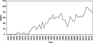
Figure 1 shows the trend of publications in the global geoscience data
management research field. The earliest literature can be traced back to 1953,
titled ??Sources of legal information
in Poland??, published in Law Library Journal. From 1953 to 1974,
the total number of publications worldwide was less than 10. From 1975 to 1997,
the number of publications fluctuated, but there was an increasing overall
trend. From 1997 to 2001, the number of publications decreased slightly. Since
2002, it has been increasing rapidly. In 2014, 99 articles were published, and
the research interest reached the highest point in history. In recent years,
the number of publications has remained high.
The influence of research results can be judged by
citations to a certain extent. Geoscience
data management research spans 66 years from 1953 (when the first paper
is published) to 2018. In this study, the
average number of citations is calculated by five-year span segments
(the last segment is six years). As shown in Figure 2, the average citation
frequency fluctuated between 0 and 3.5 before 2002. Since 2003, the average
citation frequency has increased rapidly,
reaching a maximum of 10.85 citations per article in the time zone from 2008 to
2012, when the influence reached its peak.
However, the influence
of geoscience data management was lower than the overall research influence of geoscience.
Table 2 presents a comparison between the average of citations in the geoscience
data management field in a decade and the cita-
tion base-lines of ESI. From table 2 and Figure 3, it is
clear that in the past 10 years, the average number of citations in the field
of geoscience data management only exceeded the 50% baseline of ESI in 2010 and
2014.
|
Table 1 List of data
management topics
|
|
1. Data governance
|
7. Data repository and
business intelligence management
|
|
Data assets
|
Business
intelligence
|
|
Data governance
|
Data mart
|
|
Data specialist
|
Data mining
|
|
2. Data architecture, analysis,
and design
|
Data movement (extract, transform, load)
|
|
Data analysis
|
Data repository
|
|
Data
architecture
|
8. Document, record, and
content management
|
|
Data model
|
File management
system
|
|
3. Database management
|
Records
management
|
|
Database management
|
9. Metadata management
|
|
Database management system
|
Metadata
|
|
Data
maintenance
|
Metadata
discovery
|
|
4. Data security
management
|
Metadata
publishing
|
|
Data access
|
Metadata
registration
|
|
Data erasure
|
10. Contact data management
|
|
Data confidentiality
|
Business
continuity planning
|
|
Data security
|
Market
operation
|
|
5. Data quality management
|
User data
integration
|
|
Data cleaning
|
Identity
management
|
|
Data integrity
|
Identity theft
|
|
Data richness
|
Data theft
|
|
Data quality
|
ERP software
|
|
Data quality assurance
|
CRM software
|
|
6. Reference data and
master data management
|
Location
|
|
Data
integration
|
Postcode
|
|
Master data
management
|
E-mail
|
|
Reference data
|
Telephone number
|
|
|

|
|
Figure 1 Trend
of publications in geoscience
data management research
|
Figure 2 Average
number of citations in each
time zone
|
The
distribution of publishing journals can also reflect an aspect of literature influence.
According to the statistics of the literature types, 2,391 papers in the field
of geoscience data management were published in 342 journals. Among the
journals, 249 can be found to have impact factors in the latest version of the
2018 JCR, including six Chinese journals. The interval distribution of the
impact factors of these journals is presented in Table 3. There are five journals
with an impact factor (IF) greater than 7: Environmental Health Perspectives
(8.309), Frontiers in Ecology and The
Environment (8.302), Bulletin of the
American Meteorological Society (7.804), Conservation Letters (7.279), Water
Research (7.051). Impact factors (IF) of most journals are greater than or equal to 1 but less than 4.
There were 378 articles published in the journals which IFs were greater than or equal to 1 but less
than 2. ranking the first place. While, 327 articles published in the journals
which IFs were greater than or equal
to 2 but less than 4, ranking the second.
Table 2 ESI field baselines and average citations
of geoscience data management research in a recent 10-year period
|
Subject
|
Baseline
|
2009
|
2010
|
2011
|
2012
|
2013
|
2014
|
2015
|
2016
|
2017
|
2018
|
|
Geoscience
|
0.01%
|
2,028
|
1,401
|
1,211
|
696
|
759
|
541
|
567
|
256
|
110
|
43
|
|
0.10%
|
609
|
530
|
448
|
372
|
328
|
239
|
174
|
108
|
55
|
22
|
|
1.00%
|
195
|
163
|
153
|
131
|
111
|
85
|
63
|
44
|
24
|
9
|
|
10.00%
|
59
|
52
|
48
|
41
|
35
|
28
|
22
|
15
|
9
|
3
|
|
20.00%
|
37
|
33
|
30
|
27
|
23
|
19
|
15
|
10
|
6
|
2
|
|
50.00%
|
15
|
13
|
12
|
11
|
9
|
8
|
6
|
4
|
3
|
1
|
|
average
citations
|
12.82
|
18.07
|
6.74
|
9.24
|
8.24
|
9.04
|
5.74
|
3.52
|
2.13
|
0.88
|
3.1.2 Analysis of Scientific Research Strengths of
Countries/Regions and Institutions
|
Table 3 Numbers of journals and publications in each impact-factor
interval
|
|
Impact-factor interval
|
Number of journals
|
Number of papers
|
|
IF ?? 7
|
5
|
11
|
|
4 ?? IF < 7
|
29
|
237
|
|
2 ?? IF < 4
|
82
|
327
|
|
1 ?? IF < 2
|
74
|
378
|
|
IF < 1
|
59
|
258
|
(1)
Country/region ranking of publications
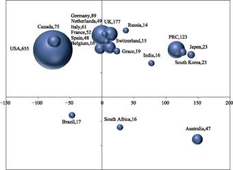
The
authors who published their articles in the field of geoscience data management
are from 88 countries/regions. As shown in Figure 3, there is a significant difference
in the number of articles among the TOP20 countries (referred to ones with the
TOP20 publications). Among them, the United States takes the lead, with 655
published papers, accounting for 27.39% of the total published papers. The
United Kingdom and China rank the second and
the third, with 177 and 123 papers, respectively. The combined proportions of the two countries (United
Kingdom, 7.40%; China, 5.14%) are less than
half of that of the United States.
They are followed by Germany (89), Canada (75), and so on.
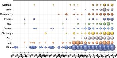
As
shown in Figure 4, the United States has conducted research in this field since
1966 and was the first among the TOP20 countries to do so. It was followed by
Britain, Italy, and France, in 1972; Belgium in 1975; and Canada, Australia,
and India in 1977. Compared with other countries, China started late, but its
research has developed rapidly. The first international journal paper was
published in 1998, and the total of published articles has increased rapidly
after 2004, indicating that China has had a high level of research interest in
this field in recent years. The United States, which holds a leading research
position, has been in a low-speed and unsteady development state since the
first paper was published in 1966. Until the 1990s, the amounts of articles and
research interest remained large.
(2) Analysis of
scientific research strengths of key institutions
Based on the statistics of the first authors from all the
papers in the research field of geoscience data management, there are 25
institutions with 6 papers or more (hereinafter
referred to as the TOP25 key institutions), as shown in Table 4. The key
institutions are concentrated in the United States (17), the United Kingdom
(5), China (2), and Canada (1). These countries account for 68%, 20%, 8%, and
4%, respectively, of the total number of institutions. The two Chinese
institutions in the TOP25 are Wuhan University (11 papers) and Peking
University (7 papers).
|
|
|
|
Figure 3 Distribution
of papers in TOP20
countries
|
Figure 4 Paper
output-time matrix of the
TOP10 countries
|
Loughborough University, which ranked first with regard to
the number of papers, published four papers for the first time in 1998.
Although the papers were published relatively later, the number of papers was
relatively large. 1998?C2009 was the most active period of research at
Loughborough University. By 2010, the number of papers published per year was
reduced, and no papers were published in the past three years. The active
period for publishing papers at the University of Illinois at Chicago was
1998?C2007. After 2008, the number of papers published per year decreased
significantly. The active research period at the National Oceanic and Atmospheric Administration of the United States was
2002?C2010. The active research period at Wuhan University in China was 2003 to
the present. The University of Kentucky started publication later, but it has
been in an active period of research since 2014.
Table 4 Publications and citations of the TOP25
first author??s institutions
|
Institution
of the first author
|
Number of papers
|
Number of
citations
|
Citation per-
centage (%)
|
Average
number of citations per paper
|
|
Loughborough University
|
29
|
117
|
1.21
|
4.03
|
|
University
of Illinois at Chicago
|
16
|
56
|
0.67
|
3.50
|
|
US
National Oceanic and Atmospheric Administration
|
15
|
19
|
0.63
|
1.27
|
|
Wuhan
University
|
11
|
11
|
0.46
|
1.00
|
|
University
of Kentucky
|
10
|
70
|
0.42
|
7.00
|
|
City
University London
|
9
|
53
|
0.38
|
5.89
|
|
Florida
State University
|
9
|
83
|
0.38
|
9.22
|
|
Indiana
University
|
9
|
110
|
0.38
|
12.22
|
|
University
of Illinois at Urbana-Champaign
|
9
|
56
|
0.38
|
6.22
|
|
The
University of Sheffield
|
9
|
118
|
0.38
|
13.11
|
|
University
of Southern California
|
8
|
58
|
0.33
|
7.25
|
|
Victoria
University of Wellington
|
8
|
7
|
0.33
|
0.88
|
|
Michigan
State University
|
7
|
103
|
0.29
|
14.71
|
|
Peking
University
|
7
|
7
|
0.29
|
1.00
|
|
University
of Michigan
|
7
|
56
|
0.29
|
8.00
|
|
University
of Toronto
|
7
|
17
|
0.29
|
2.43
|
|
Columbia
University
|
6
|
304
|
0.25
|
50.67
|
|
US
National Optical Astronomy Observatory
|
6
|
12
|
0.25%
|
2.00
|
|
Purdue
University
|
6
|
24
|
0.25%
|
4.00
|
|
State
University of New York at Albany
|
6
|
186
|
0.25%
|
31.00
|
|
University
College London
|
6
|
2
|
0.25%
|
0.33
|
|
University
of Maryland
|
6
|
67
|
0.25%
|
11.17
|
|
University
of Pittsburgh
|
6
|
68
|
0.25%
|
11.33
|
|
University
of Tennessee
|
6
|
58
|
0.25%
|
9.67
|
|
University
of Wisconsin
|
6
|
32
|
0.25%
|
5.33
|
Although Loughborough University
ranks first with regard to the number of papers published, the average number
of citations per paper is only 4.03, which is lower than the average number of
citations in the field (6.55). Although Columbia University published fewer
papers (6 papers), the average number of citations per paper is 50.67, ranking
first. The number of papers published by the State University of New York at
Albany is 6, and the average number of citations per paper is 31. Among the
TOP25 institutions, 11 of them have more than the average of citations, and
most of these institutions are located in the United States. The average of
citations per paper published by Wuhan University and Peking University in
China is 1.
3.1.3 Subject Branch and Relationship Analysis
According
to the subject classification standard of ??Web of Science categories??, we statistically
analyzed the subjects of the literature in the field of geoscience data management
and listed the top 20 disciplines (referred to as the TOP20 subjects) in order
of the number of publications. See Table 5 for details. The statistical results
indicated that the research papers on global geoscience data management
involved 118 subjects. Among them, information science and library science had
the most papers (1,411), followed by information systems and computer science
(579 papers). The total number of papers for the two subjects was 1990, which
is an absolute proportion of the whole number of papers related to geoscience
data management.
The TOP15 Web of
Science (WoS) subjects in the field of geoscience data management and the
corresponding first-level classifications of ??geoscience data
sharing platform classification and cataloging system??[27] are
presented in Table 6. The total number of publications in the TOP15 subjects is
1,174. Among the TOP15 subjects, the following WoS sub-disciplines have100
papers or more: environmental science, remote sensing, geology,
multidisciplinary integrated geoscience, water resources, and environmental
research. According to this classification, the TOP15 WoS sub-disciplines can
be classified into six first-level classifications. The terrestrial surface
includes 8 sub-disciplines, with 703 papers, accounting for 59.9% of the total.
Remote-sensing data account for 16.0% with 188 papers. Natural resources
include three sub-disciplines, with 154 papers, accounting for 13.1%.
Oceanography accounts for 5.3%, with 62 papers. Atmospheric accounts for 4.0%, with
47 papers. Solid earth and ancient environment accounts for 1.7%, with 20
papers.
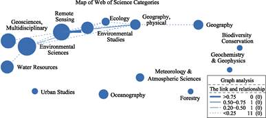
The subjects of WoS classification
system are in multipoint system, and an article may belong to multiple
subjects. To reveal this relationship, we drew the subject relationship map of
the papers related to the TOP15 disciplines, and the results are presented in
Figure 5. The sizes of the circles in the figure indicate the numbers of papers
published (by subject), and the line
thickness between the circles indicates the relative number of papers belonging
to two or more subjects at the same time. As shown, the fields of environmental
sciences and remote sensing not only had a large number of articles, but also
closely related to other subjects, particularly remote sensing and environmental
research and physical geography.
Table 5 Number of papers
published in the TOP20 subjects
|
Subject
|
Number of papers
|
Subject
|
Number of
papers
|
|
Information science and library science
|
1,411
|
Communication
|
78
|
|
Information system computer science
|
579
|
Electrical and electronic engineering
|
76
|
|
Environmental science
|
223
|
Physical geography
|
73
|
|
Remote-sensing science
|
188
|
Geography
|
65
|
|
Interdisciplinary applied computer science
|
164
|
Environmental engineering
|
62
|
|
Multidisciplinary geoscience
|
150
|
Oceanography
|
62
|
|
Imaging science and photographic technology
|
117
|
Law
|
58
|
|
Water resources
|
112
|
Astronomy and astrophysics
|
56
|
|
Environmental research
|
101
|
Artificial intelligence computer science
|
55
|
|
Electric communications
|
98
|
Management
|
54
|
Table 6 TOP15
subjects among geosciences in WoS
|
Number
|
WoS category
|
Number of papers
|
First-level classification
|
|
1
|
Environmental science
|
223
|
Terrestrial surface
|
|
2
|
Remote
sensing
|
188
|
Remote-sensing
data
|
|
3
|
Multidisciplinary
geoscience
|
150
|
Terrestrial
surface
|
|
4
|
Water
resources
|
112
|
Natural
resources
|
|
5
|
Environmental
studies
|
101
|
Terrestrial
surface
|
|
6
|
Physical
geography
|
73
|
Terrestrial
surface
|
|
7
|
Geography
|
65
|
Terrestrial
surface
|
|
8
|
Oceanography
|
62
|
Ocean
|
|
9
|
Meteorology and atmospheric science
|
47
|
Atmosphere
|
|
10
|
Ecology
|
43
|
Terrestrial
surface
|
|
11
|
Urban
studies
|
26
|
Terrestrial
surface
|
|
12
|
Diversity
protection
|
22
|
Terrestrial
surface
|
|
13
|
Forestry
|
22
|
Natural
resources
|
|
14
|
Multidisciplinary
agriculture
|
20
|
Natural
resources
|
|
15
|
Geochemistry
and geophysics
|
20
|
Solid
earth and paleoenvironment
|
3.2 Research Field Division and Progress Review Based on
Graph Analysis
3.2.1 Research Field Division
All the
data in the field of geoscience data management were regarded as a dataset
based on the results of literature retrieval, and the ??Author Keyword?? field of
the article was cleaned manually using the DDA software. 101 keywords with a
frequency greater than4 were selected from the 2,609 keywords as the analysis
objects, and the data of high-frequency keywords were clustered using the
VOSviewer software to generate a keyword co-occurrence relationship network map
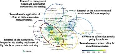
(Figure 6).
The keywords can be divided into six
research areas according to the analysis of this map and expert interpretation:
(1) research on the management, integration, and sharing mechanism of big data
for environmental monitoring; (2) research on the main content and evolution of
information policy; (3) research on management models and systems that support
decision making; (4) research on the open-access policies for scientific research
data; (5) research on the application of GIS as an Earth science data
management tool; and (6) research on information security policy formulation.
|
|
|
|
Figure
5 Relationship
map of the TOP15 key
subjects
|
Figure
6 Time-evolution
diagram of the geoscience data management research field
|
3.2.2 Relevance Analysis of Research Fields
Table 7
presents the clustering parameters of the foregoing research fields according
to the number of core topics. The average citation frequency of the core topics
in the analysis results represents the average citation frequency of the papers
containing core topics. The average correlation strength represents the
closeness of the connection among core topics contained in the cluster. Higher
average correlation strength for a cluster corresponds to a higher
co-occurrence strength between the core topics and more concentrated research.
Conversely, a lower collinear strength corresponds to more scattered research.
The total correlation strength of the core subject represents the importance of
the subject in the co-occurrence network. Higher correlation strength indicates
that the subject is more important for the construction of the network.
??Research on the management,
integration, and sharing mechanism of big data for environmental monitoring??
had the highest average correlation intensity; i.e., it is the topic with the
most concentrated research content and has relatively little crossover with
other research contents. It is followed by ??Research on management models and
systems that support decision making??, which mainly focuses on the policy
research of decision support and the construction of related systems. ??Research
on information security policy formulation?? has the lowest average correlation
strength; i.e., it is the most divergent topic with regard to research content.
It has many crossovers with other research contents, including multiple
crossovers with geoscience data acquisition, management, and integration, as
well as computer science and cryptography.
Table 7 Clustering parameters of research fields
|
No.
|
Research topics
|
Number of core topics
|
Mean time of occurrence
|
Average citation frequency
|
Average correlation strength
|
|
1
|
Research on the management, integration, and sharing mechanism
of big data for environmental monitoring
|
25
|
2011
|
7.52
|
23.32
|
|
2
|
Research
on the main content and evolution of information policy
|
20
|
2008
|
12.6
|
15.35
|
|
3
|
Research on the management model and system of supporting
decision
|
16
|
2010
|
15.47
|
10.06
|
|
4
|
Research
on the open-access policy for scientific research data
|
14
|
2012
|
16.56
|
20.71
|
|
5
|
Research
on the application of GIS as an earth science data management tool
|
13
|
2010
|
8.32
|
13.54
|
|
6
|
Research
on information security policy formulation
|
12
|
2008
|
17.82
|
8.58
|
3.2.3 Analysis of Research Progress in Various
Fields
As shown in Table 7, among the six research fields of geoscience
data management, the earliest ones are ??Research on management models and
systems that support decision making?? and ??Research on information security
policy formulation??, both of which appeared in 2008. The latest field to appear
was ??Research on open-access policy for scientific research data??, which was
seen in 2012 and is an emerging research topic.
(1)
Research on The
management, integration, and sharing mechanism of big data for environmental monitoring
The
International Geophysical Year (1957‒1958) and the International Biological Program
(1964‒1974) are the embryonic forms of big data research on the ecological
environment and are referred to as ??big scientific research??. The objective is
to obtain a large number of reliable observation data to study the Earth??s
spheres and problems with the ecological environment. These studies led to the
development of an ecosystem research network based on long-term positioning
observations, for obtaining comprehensive observation data about the ecological
environment. Academic journals such as Nature[28]
published special issues discussing big data in 2008, indicating that big
data research had received worldwide attention and recognition. As indicated by
Table 7, there are 25 core topics in this field, among which the main core
keywords include ??big data management??, ??data sharing??, ??monitoring
technology??, and ??data archive??. Among the 100 papers with the highest citation
frequencies in all fields of geoscience data management, there are 15 papers
related to big data of the ecological environment.
The
main research content was the research on management systems, integration
methods, and sharing mechanisms of big data obtained by various monitoring
systems in the field of environmental science. The fields covered by big data
include different large-scale sky survey observation data[29], river
basin and air pollution monitoring data[30], agricultural resources
and production-related data[31], meteorological data[32],
and marine data[33]. The research on data management systems is
closely combined with the development of management systems. The development of
the data integration method also involves the construction of network
infrastructure. Data sharing mechanisms need to be concerned with copyright
issues, privacy issues, and collaboration systems. The mean time of occurrence
of this field is 2011, and it has been a popular research topic, receiving
continuous attention in the Chinese and foreign academic circles.
(2)
Research on main
content and evolution of information policy
There
are 20 hot topics in the information policy field, and the keywords are ??information
policy??, ??public policy??, ??policy information??, and ??model??. The main research
focus is to analyze and summarize the information policy formulation and
practices of various countries. Most of the publications are review papers[34],
public opinions[35], etc.
China and Europe are focused mostly, and France and the United Kingdom
are also major research area. Government-level information policies include
intellectual property policies, communication policies, public information dissemination
policies, and information acquisition policies. The concept of information
policy can be traced back to the 1990s[36] and is the earliest topic
of data management research. Lately, the research on information policy and its
implementation effect[37?C38], technical standards of system
interoperability, open-access system, information processing, were concerned, and
the formulation of a complete information-technology standard policy was
proposed[39].
(3)
Research on
management models and systems that support decision making
There
are 16 hot topics in geoscience data management models field, and the keywords
include ??decision making??, ??decision support??, ??management model??, and ??environmental
policy??. The main research focus is on designing a management model for
decision support, and the core issues include data acquisition, data quality,
sustainability, and knowledge management[40]. Additionally, the
development of corresponding management platforms and other key technical
research should be pursued. This research on decision support is mainly applied
to consulting issues related to environmental monitoring and protection[29],
and there are also cases of electric vehicles and medical issues[41].
(4)
Research on
open-access policy for scientific research data
There
are 14 hot topics in open access data field. The keywords include ??research data??,
??research data management??, ??research data sharing??, ??data access??, and ??data
sharing behavior??. The average citation frequency is 16.56, which is only lower
than that of ??Research on information security policy formulation??. The main
research content in this field is related to research on open access of
scientific research data generated or purchased by universities, research
institutions, and governments. The specific issues include management support,
the sharing mechanism, the implementation approach, relevant legislation, and
service licensing. The scientific research information involved includes both
data directly generated by subject research and resources purchased through
various methods.
Many
scholars have conducted multidimensional investigations on the behavior and intention
of scientific data sharing[42?C46]. As early as 1985, Fienberg et al. proposed the sharing of
scientific research data. Some authors considered that a compulsory sharing policy
for scientific research data was necessary in 1995[47]. In 2003,
publication sharing attracted attention, and the United States issued the
??Scientific Literature Public Access of Science Act?? (Public Access of Science
Act, commonly known as the Sabo Act) in the same year. The proposal calls for
amending the current copyright protection laws in the United States to exempt
copyright protection for publicly funded research results. The publication and
sharing of original scientific data received attention around 2011[48].
Supporters of open access proposed an enhanced version of the ??Fair Access to
Science and Technology Research (FASTR) Act?? until February 2013. This
memorandum was a milestone in the development of open access to scientific data[49].
Additionally, governments such as the United Kingdom and Denmark place
considerable importance on the formulation of open-access
policies. In the United Kingdom in particular, a national open-access policy
was initially formed through RCUK (Research Councils UK), and the opinions of
all parties have been incorporated into the implementation, leading to gradual
improvements. The average year of formation in this field is 2012, and the
topic continues to attract attention in Chinese and foreign academic circles.
(5)
Research on
application of GIS as earth science data management tool
There
are 13 hot topics in GIS applications, and the keywords include ??geospatial
data??, ??geographic data management??, ??graphic database??, ??topology??, and ??data
integration??, mainly based on the geographic information system as the core
tools or research objects unfolded. The research issues include the integration
and management of geospatial data, the mechanism for sharing geospatial data
among multiple subjects, the development of related management systems, and the
design of geographic services. The main technical issues to be discussed
include system interoperability, data standardization and integration, network
technology development, infrastructure construction for spatial data
acquisition, and semantic retrieval. The application fields include mineral
resource exploration, water resource management, waterway data management, biodiversity
protection, and architectural heritage surveying. Additionally, practical
research in this field has been conducted in Europe and Central Asia. The
foregoing research content can be collectively referred to as ??geospatial data
management??. Geospatial data management links data acquisition, data modeling,
data visualization, and data analysis. It makes the continuous availability and
replicability of geospatial data possible. Four major achievements have been
made in geospatial data management research in the past 10 years. First,
GIS/BIM integration has been promoted at the data, process, and application
levels[50?C54], which has improved the level of geospatial data
management. Second, topology is taken as a key concept of geospatial data
management to construct the entity relationship model[55?C56]. Third,
significant progress has been made in the construction of
three-/four-dimensional geospatial databases. For example, the parallelization
of queries using n-dimensional space-filling curves has been verified[57].
Fourth, the GeoAI approach is used for geospatial data management to provide a
more efficient solution for intensive use of data sources, including geoscience[58].
The average year of formation in this field is 2010, and the field has broad
prospects for development.
(6)
Research on
information security policy formulation
There
are 12 hot topics in the data and information security field. The keywords include
??information security??, ??security policy??, ??system policy??, ??research
framework??, ??information science??, and ??public management??. The average
citation frequency is 17.82, ranking first among the six research fields. The
research in this field involves the formulation of network security strategies
for geographic scientific information in complex network environment[59?C60].
The field is characterized by multidisciplinary research, involving subjects
such as cryptography, public management, and
public policy formulation. The data and information holders involved include
universities, governments, and commercial institutions. Additionally, research
in this field has applications in water management and agricultural production
in Africa.
4 Conclusion and Prospects
Since the concept of data management was proposed, the total
of articles published related to earth science data management has an increasing
trend. This event indicated that the hot topic on data management has increased
slowly in the early period from 1957?C1997, and began to be increased rapidly since
2002. There were three stages in the development of related fields: the
embryonic stage (1953?C1974), the growth stage (1975?C1997), and the formation
and development stage (1998?Cpresent). It is obviously that the United States
took the lead in establishing the first data management law (the ??Freedom of
Information Act?? in 1966); it is true that research on geoscience data management
had already begun to pay attention from more than 10 years earlier in Poland.
It can be inferred that international geoscience data management research
continues to lag behind the development of geoscience research and is far below
the overall impact of geoscience research. China should further strengthen its
research on geoscience data management and strive to become a world leader as
soon as possible.
With
regard to numerous comprehensive indicators, such as the number of papers published,
key institutions, and citation frequency, the United States is in the leading
position in the field of geoscience data management research, followed by the
United Kingdom. Research in this field is on the rise in China; the number of
publications is exceeded only by that of the United Kingdom, and there is room
for development and improvement. Among the top 25 key institutions, Loughborough
University, University of Illinois at Chicago, National Oceanic and Atmospheric
Administration, Wuhan University, and University of Kentucky published the most
papers. The average number of citations per paper of Columbia University, the
State University of New York at Albany, and Michigan State University was
larger. The results indicate that institutions with a higher level of research
interest are not necessarily those with greater influence. In the future, we
should focus on the overall research and development plans of institutions with
greater influence.
Geoscience
data management research involves non-geoscience disciplines, such as information
science & library science, and information system computer science, and the
fields with a large data volume or information-technology advantages are developing
rapidly. This confirms that information science & library science,
information system computer science, etc. have become the foundation of the
main theories and methods of geoscience data management research. Among the
sub-disciplines of geoscience, data management research in the fields of
environmental science, remote sensing, geology, multidisciplinary geoscience,
water resources, and environmental study confers clear practical advantages and
has developed rapidly. Although the research on land-surface monitoring based
on remote-sensing data has prominent advantages, the research on geoscience
data management will have substantial potential for development in various
disciplines under the current data-intensive scientific research paradigm.
Based on the graph analysis, the geoscience data
management can be divided into six research fields: (1) the management, integration, and sharing mechanism of big
data for environmental monitoring; (2) the main content and evolution of
information policy; (3) management models and systems that support decision
making; (4) open-access policies for scientific research data; (5) the
application of GIS as an Earth science data management tool; and (6) information
security policy formulation. Among them, geospatial data management has developed
into an interdisciplinary scientific field, with scientific methods, processes,
algorithms, and systems that can extract knowledge, patterns, and conclusions
from unstructured and structured data. Research on geospatial data management
will play a significant role in the fields of geoscience
big data research and data management decision models. The key future research
directions of geospatial data management are as follows: (1) semantics,
geometry, and topology may become key concepts supporting geospatial data modeling
and management. (2) direct application of in situ geographic computing
of data flow libraries and objects to sensors will completely change geographic
information science and geospatial data management. (3) research and
applications of geospatial data management based on geoAI will be further
developed.
References
[1] Guo, H. Big Earth Data: a
new frontier in earth and information sciences [J]. Big Earth Data, 2017, 1(1/2): 4‒20.
[2]
Guo, Hu. D.
Scientific big data??a footstone of national strategy for big data [J]. Bulletin of Chinese Academy of Sciences,
2018, 33(8): 768‒773.
[3]
Boulton, G.
The challenges of a big data earth [J]. Big
Earth Data, 2018, 2: 1‒7.
[4]
Wang, J. L.,
Yang, Y. P., Zhu, Y. Q., et al. Data
archiving progress and data types analysis of national basic research program
of China (973 Program) in resource and environment field [J]. Advances in Earth Science, 2009, 24(8):
947‒953.
[5]
Si, Li.,
Xing, W. M. Scientific data management and sharing policies in foreign
countries: investigation and inspiration to us [J]. Information and Documentation Services, 2013(1): 61‒ 66.
[6]
Ding, P.
Data management policy for scientific research in overseas universities [J]. Library Tribune, 2014(5): 103‒110.
[7]
Li, J. H.,
Yu, L. Q. Review on progress and trend of international scientific databases [J].
E-science Technology & Application, 2009(1): 6‒13.
[8]
Hou, X. G.,
Luo, Y. F. The new characteristics of research priorities of national Center
for atmospheric research [J]. Advances in
Earth Science, 2006(7): 751‒756.
[9]
White, R. M.
Geophysical data management??why [J]. Bulletin
of the Amrican Meteorolgical Society, 1969, 50(3): 143.
[10]
NASA
Distributed Active Archive Centres [EB/OL]. http://gcmd.gsfc.nasa.gov/. 2005.
[11]
NASA??s
Global Change Master Directory [EB/OL]. http://gcmd.gsfc.nasa.gov/. 2007.
[12]
The
Canadian Earth Observation Network [EB/OL. http://www.geoconnections.org].
2005.
[13]
Wang, J. L.,
Shi, L., Wang, Y. J., et al. Analysis
of the modes of aggregation of scientific data and proposals for its
development in China [J]. Advances in
Earth Science, 2020, 35(8): 839‒847.
[14]
Repository
Finder [EB/OL]. https://repositoryfinder.datacite.org/.
2020-12-01.
[15]
Vantrump, G.,
Miesch, A. T. The U. S. geological survey rass-statpac system for management
and statistical reduction of geochemical data [J]. Computers & Geosciences,
1977, 3(3): 475‒488.
[16]
Li, J.,
Chen, C. C. A study on the metadata of earth Science data (Geo-metadata) [J]. Geographical Research, 1997(1): 31‒38.
[17]
Sun, J. L.,
Li, S. Geo-data sharing and data-grid [J]. Earth
Science, 2002(5): 539‒543.
[18]
Data Processing
Division of Development Research Center, China Geological Survey. The updated
version of Regional Geochemical Data Management Information System (GeoMDIS
2003) comes out??a practical tool for prospecting geochemists [J]. Geologcal Bulletin of China, 2003(7):
547‒548.
[19] Du, Y. Y., Yang, X. M.,
Wang, J. G. Construction and implementation of multi-sources spatial data management
system of China??s coastal zone and offshore [J]. Acta Oceanologica Sinica, 2003(5): 38‒48, 57.
[20]
Wang, J. L.,
You, S. C., Xie, C. J. Analysis and design of metadata standard structure for geosciences
data Sharing [J]. Geography and
Geo-Information Science, 2005(1): 16‒18, 37.
[21]
Xiao, J. H., Wang, H. Z., Peng, Q. S., et al. Research on the construction of cloud platform for the spatio-temporal
big data management and application [J]. Bulletin
of Surveying and Mapping, 2016(4): 38‒42.
[22]
Liu, C.,
Guo. H. D., Uhlir, P. F., et al.
GCdataPR: Infrastructure for data publishing repository & sharing
in/for/with developing countries [J]. Journal
of Global Change Data & Discovery,
2017, 1(1): 3‒11.
[23]
Wang, J. L., Wang, Y., Bu, K., et
al. Practice in the core trust seal certification of World Data Center??a
case study of WDC??renewable resources and environment [J]. Journal of Agricultural Big data, 2019, 1(3): 71‒81.
[24]
Geoscience
Dictionary Editorial board. Geoscience Dictionary (Basic Subject Volume) [M].
Beijing: Geological Publishing House, 2006.
[25]
Chen, C. M.
CiteSpaceIII [DB/OL]. http:??cluster ischool.Drexeledu/ cchen/citespace/ download/. 2016.
[26]
Centre for
Science and Technology Studies, Leiden University. VOSviewer
Version 1.6.4 [DB/OL]. http: //www.vosviewer.com/. 2016.
[27]
Wang, J. L.,
Lin, H., Ran, Y. Y., et al. A study
of earth system science data classification for data sharing [J]. Advances in Earth Science, 2014, 29(2): 265‒274.
[28]
Frankel, F.,
Reid, R. Big data: distilling meaning from data [J]. Nature, 2008, 455(7209): 30‒30.
[29]
Ivezic, Z.,
Lupton, R. H., Schlegel, D. SDSS data management and photometric quality
assessment [J]. Astronmische Nachrichchten,
2004, 325(6/8): 583‒589.
[30] Chen, X. Y., Shao, S., Tian, Z. H. Impacts of
air pollution and its spatial spillover effect on public health based on China??s big data sample [J]. Journal of
Cleaner Production, 2017, 142: 915‒925.
[31]
Steiner, J.
L., Sadler, E. J., Chen, J. S. Sustaining the earth??s watersheds-agricultural
research data system: overview of development and challenges [J]. Journal of Soil and Water Conservation,
2008, 63(6): 569‒576.
[32]
Muller, C. L.,
Chapman, L., Grimmond, C. S. B. Toward a standardized metadata orotocol for
urban meteorological networks [J]. Bulletin
of the American Meteorological Society, 2013 94(8): 1161‒1185.
[33]
Costello, M.
J. Distinguishing marine habitat classification concepts for ecological data
management [J]. Marine Ecology Progress
Series, 2009, 397: 253‒268.
[34]
Amante, M. J,
Correia, A. M. R., Wilson, D. Information policy in the EU: legislative
framework in Portugal (1989-1992) [J]. Cadernos
BAD, 1994(2): 9‒28.
[35]
Lemke, A. A.,
Wolf, W. A., Hebert-Beirne, J. Public and biobank participant attitudes toward
genetic research participation and data sharing [J]. Public Health Genomics, 2010, 13(6): 368‒377.
[36]
Itermon, R.,
Relyea, H. C. Information Policy [M].
Encyclopedia of Library and Information Science (Volumn 48), Kent, Allen. ed. New
York: MaroelDekker, 1991: 176‒204.
[37]
Shuler, J. A.
Citizen-centered government: information policy possibilities of the 108th
Congress [J]. Journal of Academic Librarianship,
2003, 29(2): 107‒110.
[38]
Hardwicke,
T. E., Mathur, M. B., MacDonald, K. N. G., et
al. Data availability, reusability, and analytic reproducibility:
evaluating the impact of a mandatory open data policy at the journal cognition [J].
Royal Society Open Science, 2010, 5(8): 180448.
[39]
Moen, W. E.
Interoperability of information access: Technical standards and policy
considerations [J]. Journal of Academic Librarianship,
2000(2): 129‒132.
[40]
Michener, W.
K. Ecological data sharing [J]. Ecological
Informatics, 2015, 29: 33‒44.
[41]
Nakayama, T.
Evidence-based healthcare and health informatics: derivations and extension of
epidemiology [J]. Journalof Epidemiology,
2006, 16(3): 93‒100.
[42]
Cech, T. R.,
Eddy, S. R., Eisenberg, D., et al.
Sharing publication-related data and materials: responsibilities of authorship
in the life sciences [J]. Plant
Physiology, 2003, 132(3): 19‒24.
[43]
Parr, C. S.,
Cummings, M. P. Data sharing in ecology and evolution [J]. Trends in Ecology and Evolution, 2005, 20 (7): 362‒363
[44]
Fienberg, S.
E., Martin, M. E., Straf, M. L. Sharing Research Data [M]. Washington, D. C:
National Academy Press, 1985.
[45]
Constant, D.,
Kiesler, S., Sproull, L. What??s mine is ours, or is it? A study of attitudes
about information sharing [J]. Information
Systems Research, 1994, 5: 400?C421.
[46]
Matzler, K.,
Renzl, B., Muller, J., et al.
Personality traits and knowledge sharing [J]. Journal of Economic Psychology, 2008, 29: 301‒313.
[47]
McCain, K.
Mandating sharing: journal policies in the natural sciences [J]. Science Communication, 1995, 16:
403‒431.
[48]
Piwowar, H.
A. Who shares? Who doesn??t? Factors associated with openly archiving raw
research data [J]. PLoS One, 2011,
6(7): e18657.
[49]
SPARC
applauds White House for Landmark Directive Opening up Access to Scientific
Research [EB/OL]. http: //www.sparc.arl.org/. 2013-08-28.
[50] Zhu, J., Wright, G., Wang, J.,
et al. A critical review of the
integration of geographic information system and building information modelling
at the data level [J]. ISPRS
International Journal of Geo-Information, 2018, 7: 66.
[51]
Sacks, R.,
Ma, L., Yosef, R., et al. Semantic
enrichment for building information modeling: procedure for compiling inference
rules and operators for complex geometry [J]. Journal of Computing in Civil Engineering, 2017, 31: 04017062.
[52]
Irizarry, J.,
Karan, E. P., Jalaei, F. Integrating BIM and GIS to improve the visual
monitoring of construction supply chain management [J]. Automation in Construction, 2013, 31: 241?C254.
[53]
Amirebrahimi,
S., Rajabifard, A., Mendis, P., et al.
BIM-GIS integration method in support of the assessment and 3D visualisation of
flood damage to a building [J]. Journal of Spatial Science, 2016, 61: 317?C350.
[54]
Kang, T. W.,
Hong, C. H. A study on software architecture for effective BIM/GIS-based
facility management data integration [J]. Automation
in Construction, 2015, 54: 25?C38.
[55]
Ozel, F.
Spatial databases and the analysis of dynamic processes in buildings [C]. In
Proceedings of the Fifth Conference on Computer Aided Architectural Design
Research in Asia, Singapore, 2000, 2: 97?C106.
[56]
Bradley, P.
E., Paul, N. Using the relational model to capture topological information of
spaces [J]. The Computer Journal,
2010, 53: 69?C89.
[57]
Guan, X., van
Oosterom, P., Cheng, B. A parallel N-dimensional space-filling curve library and
its application in massive point cloud management [J]. ISPRS International Journal of Geo-Information, 2018, 7: 327.
[58]
VoPham, T.,
Hart, J. E., Laden, F., et al.
Emerging trends in geospatial artificial intelligence (geoAI): potential
applications for environmental epidemiology [J]. Environmental Health, 2018, 17: 40.
[59]
Wang, L. G. Reference model for creating
information security policy [C]. Proceedings of Information Technology and Environmental System Sciences,
2008, 2: 279‒281.
[60]
Tang, Y. L., Xu, G. A., Niu, Y. X., et
al. Information security risk analysis model based on entropy [C]. Proceedings of Information Technology and Environmental System Sciences, 2008, 4: 1146‒1150.