In Situ Soil Moisture Datasets in Zhonggou and
Zhifanggou Watershed of Longdong Loess Plateau (2017-2019)
Zhang, L. Y.1 Di, L.1*
Wu, X. Z.2* Zhang, J.1 Wang, A. M.3 Ru, H. L.3 Ni. F.1 Zhao, Z. L.1 Zhang, R. F.4 Wu, L.1 Li, H. Q.1 Su, X. L.5 Liu, J. J.6 Zhao, B. Z.1 Yang??T1
1. College of Resources and Environmental
Sciences, Gansu Agricultural University, Lanzhou 730070; China;
2. College of Earth and
Environmental Sciences, Lanzhou University, Lanzhou 730000; China;
3. Pingliang institute of soil and
water conservation Science, Pingliang 744000; China;
4. College of Life Sciences, Gansu
Agricultural University, Lanzhou 730070; China;
5. College of Agriculture,Gansu
Agricultural University, Lanzhou 730070; China;
6. Natural Resources Bureau of
Jingchuan County, Pingliang City, Pingliang 744000; China
Abstract: Zhonggou and Zhifanggou
watershed in the Longdong Loess Plateau was chosen as the research areas, and
the large-scale Robinia pseudoacacia
plantations were selected as the research objects. They were planted in the slopes
where farmland was transformed into grassland. Comprehensively considering its
slope, aspect, forestage, planting density and other factors, 10 woodlands and
3 grassland sample plots have been established in the Zhonggou watershed, and 7
sample plots covered by Cerasus humilis
shrub, alfalfa, wasteland and bare land with the four slope grades of 5??, 10??, 15??,
and 20??in the watershed of the Zhifanggou have been selected. The TRIME pipe
was buried in 2016, and the soil moisture was measured by the Time Domain Reflectometry
(TDR) method. The measured data of soil moisture were obtained in the growing
seasons from 2017 to 2019. The dataset includes: (1) Basic information of the
sample plot (i.e., slope, aspect, and main stand structure data such as vegetation
type, forest age, density, and DBH, as well as number and depth of TRIME pipe
buried); (2) Soil moisture in Zhonggou watershed including 13 sample plots from
May to October in 2017,13 sample plots from April to October in 2018, and 7
sample plots from July to October in 2019; soil moisture in the Zhifanggou
watershed including data from May to July 2017, from April to September in
2018, and from February to July in 2019. The dataset was archived in .xlsx
format with data size of 420 KB in 8 data files (compressed to 225.9 KB in two
data files).
Keywords: soil moisture; Robinia
pseudoacacia; Cerasus humilis shrub; grassland conversion; Longdong Loess Plateau
Dataset Availability Statement:
The dataset supporting this paper was published and is accessible
through the Digital Journal of Global
Change Data Repository at: https://doi.org/10.3974/geodb.2020.09.10.V1
& https://doi.org/10.3974/geodb.2020.09.11.V1.
1 Introduction
The precipitation in the Longdong Loess
Plateau, which located in eastern Gansu, is less and unevenly distributed, which results in low
forest vegetation coverage, deterioration of ecological environment and serious
soil erosion in this area. The relationship between vegetation and water
resources is the core issue of ecological restoration and vegetation construction
in the Longdong Loess Plateau. Chinese government has launched a series of key
forestry ecological projects in this region, for example, a large area of ecological
forests such as Robinia pseudoacacia, Pinus tabulaeformis, Platycladus
orientalis, Hippophae rhamnoides
and Caragana korshinskii have been
constructed. Different vegetation types and plant species have different
adaptive strategies for water use. However,
the status of spatial and temporal distribution of soil moisture was neglected
in large-scale plantation forests, especially pure plantations. In order to
meet the needs of water, the plantations have rapidly expanded their roots and
utilized deep soil water storage, resulting in the formation of soil drought
layer in a certain soil depth in perennial plantations[1?C2]. As
a result, the survival rate and preservation rate of afforestation are low.
Even if they survive, they grow very slowly and enter the degeneration stage
earlier. Therefore, the expected effect of ecological project construction
cannot be achieved[3?C4]. With the increase of forest age, the
degeneration of Robinia
pseudoacacia plantations planted with simple structure and single species were gradually
appeared. Because of its rapid growth and large water consumption, the soil
under the forest is drying seriously with the increase of forest age, forming
an obvious dry soil layer. The ecological environment is getting deterioration[5?C7].
The emergence of the problems is diametrically opposed to the original purpose
of constructing ecological restoration forests, and instead of achieving the
expected goals. As a result, the ecological restoration effect is so poor in
the later period. In this paper, two watersheds (Zhonggou and Zhifanggou) with
40 years of plantation in the Longdong Loess Plateau were selected as the sampling areas. The soil
moisture in two watersheds with different restoration modes was measured and
analyzed in order to grasp the distribution of soil moisture in the region and
guide the restoration of plantation vegetation and the sustainable development
of ecology in the region.
2 Metadata of the Dataset
The metadata of the ??soil moisture dataset from woodland
and grassland sample plots of Zhonggou watershed on Longdong Loess Plateau,
China (2017-2019)?? [8] and the ??Sample plots soil moisture
dataset from four different land uses of Zhifanggou watershed on Longdong Loess
Plateau, China (2017-2019)??[9], including authors, geographical
region, time, data format, data publishing and sharing service platform and
data sharing policy, is shown in Table 1.
3 Study Area
Zhifanggou watershed in Pingliang city, Gansu province (35??26??N?C35??33??N, 106??37??E
?C106??42??E) is located in the gully region of the Loess Plateau (Figure
1). The observation site is on the natural hillside of the Zhifanggou basin 0.9
km from Pingliang city. The
basin is a first-level branch of the Jing River. The runoff measurement in the
basin is one of main goal in the monitoring points in Gansu for the second
phase of the construction of the national soil and water conservation
monitoring network, as well as a part of information system which is a water erosion
monitoring point in the key management area of the river
Table 1 Metadata summary of ??Soil moisture
dataset from woodland and grassland sample plots of Zhonggou watershed on
Longdong Loess Plateau, China?? and ??Sample plots soil moisture dataset from
four different land uses of Zhifanggou watershed on Longdong Loess Plateau,
China (2017-2019)??
|
Items
|
Description
|
|
|
Data full name/short
name
|
Soil moisture dataset from woodland and
grassland sample plots of Zhonggou watershed on Longdong Loess Plateau, China
(2017-2019) / SoilMoistureZhonggouRiverBasin
Sample plots soil moisture dataset from
four different land uses of Zhifanggou watershed on Longdong Loess Plateau,
China (2017-2019) / SoilMoistureZhifangRiverBasin
|
|
|
Authors
|
Zhang, L. Y., Gansu Agricultural
University, 1397437506@qq.com
|
|
|
|
Di, L., Gansu Agricultural University, dili@gsau.edu.cn
|
|
|
|
Wu, X. Z., Lanzhou City University, wxz315@163.com
|
|
|
|
Zhang, J., Gansu Agricultural University,
zhangjun@gsau.edu.cn
|
|
|
|
Wang, A. M., Pingliang Institute of Soil
and Water Conservation, 593928177@qq.com
|
|
|
|
Ru, H. L., Pingliang Institute of Soil
and Water Conservation, 1175332809@qq.com
|
|
|
|
Ni, F., Gansu Agricultural University, 1356159486@qq.com
|
|
|
|
Zhao, Z. L., Gansu Agricultural
University, 1259701979@qq.com
|
|
|
|
Zhang, R. F., Gansu Agricultural
University, 2757779009@qq.com
|
|
|
|
Wu, L., Gansu Agricultural University, 2889543138@qq.com
|
|
|
|
Li, H. Q., Gansu Agricultural University,
1824047417@qq.com
|
|
|
|
Su, X. L., Gansu Agricultural University,
3091274177@qq.com
|
|
|
|
Liu, J. J., Natural Resources Bureau of
Jingchuan County, 1939225224@qq.com
|
|
|
|
Zhao, B. C., Gansu Agricultural
University, 2388455308@qq.com
Yang, T., Gansu Agricultural
University,1305004933@qq.com
|
|
|
Geographical region
|
Zhonggou and Zhifanggou watershed
Year 2017-2019 Data format .xlsx
|
|
|
Foundation
|
National Natural Science Foundation of
China (31660235)
|
|
|
Data
publisher
|
Global Change Research Data Publishing & Repository, http://www.geodoi.ac.cn
|
|
Address
|
No. 11A, Datun Road, Chaoyang District, Beijing 100101,
China
|
|
Share policy
|
Data from the Global Change
Research Data Publishing &Repository includes metadata, datasets (in the Digital Journal of Global Change Data Repository), and
publications (in the Journal of Global Change Data & Discovery). Data
sharing policy includes: (1) Data are openly available
and can be free downloaded via the Internet; (2) End users are encouraged to
use Data subject to citation; (3) Users, who are by definition
also value-added service providers, are welcome to redistribute Data subject
to written permission from the GCdataPR Editorial Office and the issuance of
a Data redistribution license; and (4) If Data are
used to compile new datasets, the ??ten per cent principal?? should be followed
such that Data records utilized should not surpass 10% of the
new dataset contents, while sources should be clearly noted in suitable
places in the new dataset[ 10]
|
|
|
Communication
and searchable system
|
DOI, DCI, CSCD, WDS/ISC,
GEOSS, China GEOSS, Crossref
|
|
|
|
|
|
|
basin.
The total area of the basin is 18.98 km2 with the altitude of 1,365-2,104
m.The annual average temperature is 8.8 ??C, the annual average sunshine hours are 2,381 h
and the pan evaporation is 1,499.2 mm, the annual average precipitation is
551.2 mm, of which 58% falls from July to September, and the soil type is
mainly loessal soil[11]. The vegetation coverage is high more than
70% in upstream due to relatively high humid, where there are secondary trees
and shrubs, the high dense grass. The vegetation coverage is about 40%-50% in
the middle reaches where is dominated by weeds, and sparse shrubs on the shady
slope. The vegetation coverage is between 20% and 40% in the downstream. There
are 7 runoff plots in Zhifanggou watershed dominated by Cerasus humilis arranged with semi-shady slopes of 5??, 10??, 15?? (two),
and 20?? (three). In addition, 15 plots are in grass slopes, 20 plots are in
bare land, and 20 plots are in alfalfa land; runoff plots are all located at
the bottom of the downstream ditch (Figure 2).
Zhonggou watershed (35??12??N, 107??27??E) is located in Guanshan Forest Farm, Jingchuan county,
Pingliang city, with an area of 2.09 km2, altitude of 1,005-1,351 m, which belongs to a temperate semi-humid climate zone.
Precipitation accounting for about 66% of the total
falls from June to September. The annual average temperature is 10.7 ??C[11] and the annual
frost-free period is about 180 days. The main topography of the study area is
composed
of plateau surface, beam slope, ditch platform and ditch bottom. The relative
elevation difference is about 350 km in the watershed. There are four main
types of soil such as black loessial, loessial soil, silty loam, and red clay.
The black loessial soil is mostly distributed in the plateau surface, the
loessial soil is mostly distributed in the beam slope, the silty loam is mostly
distributed in the ditch platform, and the red clay is mostly distributed in
the ditch bottom[12-14]. Soil erosion is
serious in the study area. The watershed is located in the transition zone of
forest and grassland. The existing forest vegetation has been artificially
planted in the past 40 years by Guanshan Forest Farm, the dominant species
planted being Robinia pseudoacacia.
Soil erosion is serious in the study area. The Information of sample plots in Zhifanggou watershed is shown in Table
2 and the Information of sample plots in Zhonggou watershed is shown in Table
3.
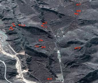
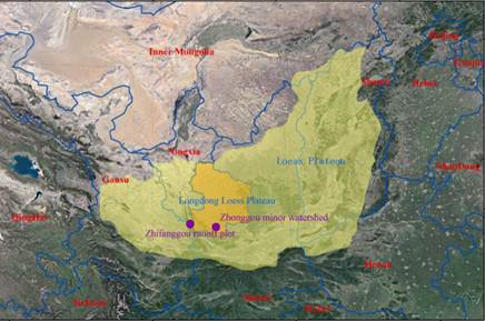
Figure 1 The relative position of Zhifanggou Figure 2 Distribution of observation samples
and
Zhonggou watershed site in Zhonggou watershed
4 Soil Moisture Observation
The soil moisture is usually measured by soil
moisture quick-monitoring instrument (TRIME-PICO) (Figure 3) and soil weight moisture is measured by the drying
method [15].
TRIME tubes were buried in 13 selected sample plots in 2016 (Figure 4-5). Soil moisture was measured every 15 days
from the middle and late April to early November. It lasted the entire growth period of the tree. The maximum test depth is
300 cm. Data is read and recorded every 20 cm, synchronized with the observation
of earth drill.
Table
2 Summary of sample plots information in
Zhifanggou watershed
|
sample site
|
Slope (??)
|
Slope
position
|
Vegetation
types
|
Land
preparation method
|
Sowing
method
|
Density (plants??ha?C1)
|
|
1
|
5??
|
Slope
bottom
|
Cerasus humilis
|
level terrace
|
hole-seeding
|
20,000
|
|
2
|
10??
|
Slope
bottom
|
Cerasus humilis
|
level terrace
|
hole-seeding
|
20,000
|
|
3
|
15??
|
Midslope
|
Cerasus humilis
|
level terrace
|
hole-seeding
|
20,000
|
|
4
|
15??
|
Midslope
|
wasteland
|
abandonment
|
|
|
|
5
|
20??
|
Midslope
|
Cerasus humilis
|
level terrace
|
hole-seeding
|
20,000
|
|
6
|
20??
|
Midslope
|
bare
land
|
abandonment
|
|
|
|
7
|
20??
|
Midslope
|
alfalfa
|
abandonment
|
sowing
|
|
* All
sample plots are in a slope direction (313??) and are buried with three 2-m
TRIME pipes with varying test depths depending on test conditions. Cerasus humilis was planted in spring
2017 and it was watered 4 times that year, and then there was no irrigation.
Table 3 Sample plots information
of Zhonggou watershed
|
Sample site
|
Geo-location
|
Forest age
(year)
|
Type of sample site
|
Geomorp-
hological site
|
Aspect
(??)
|
Slope
(??)
|
Density (plants??ha?C1)
|
Average DBH
(cm)
|
Average height
(m)
|
Canopy density
|
Trimetube
quantity
|
Measuring pipe depth (m)
|
|
1
|
35??20??25??N
107??31??2??E
|
35
|
Robiniapseudoacacia
|
ridge slope
|
233??
|
35??
|
4,563
|
7.83
|
5.63
|
0.87
|
3
|
3
|
|
2
|
35??20??32??N
107??31??9??E
|
30
|
Robiniapseudoacacia
|
tableland
|
339??
|
15??
|
2,196
|
13.22
|
11.90
|
0.82
|
3
|
3
|
|
3
|
35??20??41??N
107??31??11??E
|
25
|
Robiniapseudoacacia
|
tableland
|
332??
|
13??
|
750
|
16.24
|
13.88
|
0.8
|
3
|
3
|
|
4
|
35??20??47??N
107??31??11??E
|
25
|
Robiniapseudoacacia
|
tableland
|
9??
|
2??
|
1,600
|
15.66
|
12.83
|
0.83
|
3
|
3
|
|
5
|
35??20??44??N
107??31??55??E
|
20
|
Robiniapseudoacacia
|
ditch
platform
|
218??
|
17??
|
5,400
|
9.16
|
11.07
|
0.86
|
3
|
3
|
|
6
|
35??20??22??N
107??31??6??E
|
35
|
Robiniapseudoacacia
|
ridge slope
|
227??
|
16??
|
3,780
|
11.54
|
8.36
|
0.82
|
2
|
2
|
|
7
|
35??21??1??N
107??31??36??E
|
25
|
Robiniapseudoacacia
|
tableland
|
341??
|
8??
|
1,227
|
15.50
|
14.46
|
0.8
|
2
|
3
|
|
8
|
35??20??56??N
107??31??34??E
|
25
|
Robiniapseudoacacia
|
tableland
|
216??
|
2??
|
1,625
|
16.94
|
13.24
|
0.79
|
2
|
3
|
|
9
|
35??20??51??N
107??31??33??E
|
25
|
Robiniapseudoacacia
|
tableland
|
247??
|
18??
|
1,000
|
14.20
|
11.96
|
0.82
|
2
|
3
|
|
10
|
35??20??10??N
107??31??7.5??E
|
25
|
Robiniapseudoacacia
|
ridge slope
|
255??
|
29??
|
3,550
|
6.15
|
7.6
|
0.88
|
2
|
3
|
|
11
|
35??20??42??N
107??31??8.5??E
|
|
unused grass
|
tableland
|
239??
|
22??
|
|
|
|
|
2
|
2
|
|
12
|
35??20??44??N
107??31??2??E
|
|
unused grass
|
ridge slope
|
225??
|
35??
|
|
|
|
|
3
|
3
|
|
13
|
35??20??43??N
107??31??53??E
|
|
unused
grass
|
ditch
platform
|
257??
|
10??
|
|
|
|
|
2
|
3
|
The advantages of measuring soil moisture by using soil
moisture quick- monitoring instrument are simple operation, fast measurement
speed and continuous measurement, which can be used to measure soil surface
moisture and section moisture, and the measurement data are easy to process.
But the first three months of TRIME pipe embedded will disturb the soil and it
is not suitable for measurement.

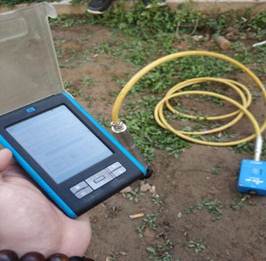
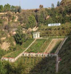
Figure 3 Observation of soil mo- Figure 4 Experimental plot
of Figure 5
Experimental plot of
isture quick-monitoring instrument Zhonggou
watershed Zhifanggou
watershed
5 Data
Results and Analysis
In the same period of 2018, we
compared the soil moisture of Robinia
pseudoacacia plantations in Zhonggou watershed with that of Cerasus humilis shrub in Zhifanggou
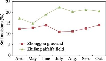
watershed (Figure 6) and soil moisture of unused grassland in Zhonggou with that
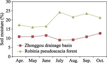
of waste grass slope in Zhifanggou (Figure 7).
|
|
|
|
Figure 6 Soil moisture of Robinia pseudoacacia plantations in
Zhonggou and Cerasus humilis shrub
in Zhifanggou
|
Figure 7 Soil moisture of unused grassland in
Zhonggou forest and waste grass slope in Zhifanggou
|
The soil moisture of Cerasus humilis forest in Zhifanggou is
higher than that of Robinia pseudoacacia
forest in Zhonggou. The soil moisture of Robinia
pseudoacacia forest in Zhougou increased slightly from April
to June, decreased from June to July, and increased slowly from August, while
the soil moisture of Cerasus humilis forest
in
Zhifanggou decreased slightly from April to May, and increased rapidly in May
to July and then there was a downward-rising-decreasing fluctuation. In
addition, the soil moisture of the Robinia
pseudoacacia forest in Zhonggou reached the minimum value of 9.01% in July,
while the soil moisture of the Cerasus humilis forest
in
Zhifanggou reached the maximum value of 24.22% in July.
The soil moisture of
alfalfa grassland in Zhifanggou was also higher than that in Zhonggou grass
slope. The soil moisture in Zhonggou grassland increased slowly from April to June,
decreases significantly from June to July, and then decreased gradually from
June to July. While the soil moisture in Zhifanggou alfalfa grassland decreased
significantly from April to May
period and July, increased rapidly from May to July, and then showed wave dynamic.
Similarly, the soil moisture of Zhonggou grassland reached the lowest value of
10.86% in July, and the soil moisture in Zhifanggou grass slope reached its
highest value of 22.35% in July.
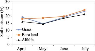
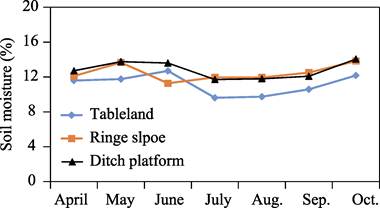
Figure 8 and Figure 9 show the
soil moisture of unused land under different vegetations in the Zhifanggou
watershed and the soil moisture of unused grassland under different landform
types in the Zhonggou watershed in 2018, respectively.
|
|
|
|
Figure 8
Soil moisture of unused land under different vegetation in
Zhifanggou watershed
|
Figure 9 Soil moisture of barren grassland
under different landform types in Zhonggou watershed
|
The soil
moisture of bare land in the Zhifanggou watershed was significantly higher than
that of barren grassland and alfalfa land. The change trend of soil moisture of
barren grassland and alfalfa land was the same, and both decreased first and
then increased. The soil moisture of barren grassland was slightly higher than
that of alfalfa land. Under different landform types, the soil moisture of
unused grassland was shown a ??S??-shaped fluctuation that first increased and
then decreased. Whether it is woodland or grassland, the soil moisture of
Zhifanggou is larger than that of Zhonggou. The reason may be that the runoff
plots in the watershed of Zhifanggou are all located in the downstream of the
watershed and close to the bottom of the valley. In the next study, a new
runoff observation field has been considered on different slope positions in
the upstream of Zhifanggou.
Author Contributions
Di, L. made the total design of the layout
of the experiment and the development of the dataset. Wu, X. Z. assisted in experimental design and
field observation layout. Zhang, L.
Y., Ren, Y. B., and Ni, F. were mainly responsible for data analysis. Wang, A.
M., Ru, M. L., Zhao, Z.L., Wu, L., and Zhang, R. F., et al. were responsible for data collection. Di, L., Zhang, L. Y.,
Zhang, J., and Wu, X. Z. carried out data verification and wrote manuscript.
References
[1]
Xu, P. H., Chen, Y. M., Wu, F.
Effects different improvement measures of degradated robinia pseudoacacia in
semi-arid loess hilly region [J]. Journal
of Northwest Forestry University, 2009, 24(4): 109?C113.
[2]
Liu, X. X., He, Q. Y., Yan, M. J., et al. Trunk sap flow dynamic characteristics of dominant and main associated
species of quercus liaotungensis community in loess hilly and semi-arid region [J].
Acta Zoologica Sinica, 2018, 38(3): 4744?C4751.
[3] Zhang,
J., Di, L., Li, X. Y., et al.
Measured soil moisture dataset of Zhonggou watershed in the Loess Plateau of
Eastern Gansu (2018) [J]. Journal of
Global Change Data & Discovery,
2019, 3(4): 349?C 355.
[4]
Liu, J, J., Cheng, L. L., Yu, X. X.. Influencing factors and
research progress of tree transpiration water consumption [J]. World forestry research, 2009, 22(4): 34?C40.
[5]
Shao, M. A., Jia, X. X., Wang, Y. Q., et al. Research progress and Prospect of soil dry layer in Loess Plateau
[J]. Progress in Earth Science, 2016,
31(1): 14?C22.
[6]
Wang, L., Shao, M. A., Wang, Q.
J., et al. Comparison of soil drying
status between natural forest and Robinia pseudoacacia plantation in Ziwuling
of Loess Plateau [J]. Acta botany Sinica,
2005(7): 1279?C1286.
[7]
Jia, X. X.,
Shao, M. A., Zhu, Y. J., et al. Soil
moisture decline due to afforestation across the Loess Plateau, China [J]. Journal of Hydrology, 2017, 546: 113?C122.
[8]
Zhang, L. Y., Di, L., Wu, X. Z. Soil moisture dataset from woodland
and grassland sample plots of Zhonggou watershed on Longdong Loess Plateau,
China (2017?C2019) [J/DB/OL]. Digital
Journal of Global Change Data Repository, 2020. https://doi.org/10.3974/geodb.2020.09.10.V1.
[9]
Zhang, L. Y., Di, L., Wu, X. Z. Sample plots soil moisture dataset
from four different land uses of Zhifanggou watershed on Longdong Loess
Plateau, China (2017?C2019) [J/DB/OL]. Digital
Journal of Global Change Data Repository, 2020. https://doi.org/10.3974/geodb.2020.09.11.V1.
[10] GCdataPR
Editorial Office. GCdataPR data sharing policy [OL]. https://doi.org/10.3974/dp.policy.2014.05
(Updated 2017).
[11] Wang,
M. Y., Wang, B. T. Effects of different soil and water conservation measures on
annual runoff and sediment yield in watershed of Loess Plateau: a case study of
Zhifanggou, Pingliang [J]. Forestry
science, 2016, 52(8): 10?C20.
[12] Han,
F., Ren, Y., Wang, A. M., et al.
Response of soil moisture in Robinia
pseudoacacia forest land to rainfall in Jingchuan Zhonggou watershed, Gansu
province [J]. Agricultural science and
information, 2015(1): 31?C33.
[13]
Jing, G. Y. Study on ecological and hydrological functions of
litter layer and soil layer of artificial Robinia
pseudoacacia forest in Loess Plateau of Eastern Gansu [D]. Lanzhou: Gansu
Agricultural University, 2017.
[14]
Jing, G. Y., Di, L., Wang, A. M., et al. Study on soil water physical properties and permeability of
different age artificial Robinia pseudoacacia Forests in Jingchuan, Gansu
Province [J]. Journal of Sichuan Agricultural
University, 2017, 35(2): 193?C198
[15]
Brief introduction of the National Standard of the People??s
Republic of China on Long-term Positioning and Observation of Forest Ecosystems
(GB/T33027??2016) in China [J]. Journal of
Temperate Forestry Research, 2018, 1(1): 6, 36.