Dataset of Farming-pastoral Ecotone Boundaries in Northern China during Four Decades (1970s, 1980s, 1990s and 2000s)
Shi, W. J.1,2* Liu, Y. T.1,2 Shi, X. L.3
1. Key Laboratory of Land Surface Pattern and Simulation, Institute of Geographic Sciences and Natural Resources Research, Chinese Academy of Sciences, Beijing 100101,China;
2. College of Resources and Environment, University of Chinese Academy of Sciences, Beijing 100049, China;
3. College of Resources and Environment Sciences, Key Laboratory of Environmental Evolvement and Ecological Construction of Hebei Province, Hebei Normal University, Shijiazhuang 050024, China
Abstract: The delineation of the farming-pastoral ecotone (FPE) boundary in Northern China is an important basis for research concerning the ecological environment, climate change and land use change. This dataset drew on the boundaries established in previous studies and used the mean annual precipitation as well as the area-percentage of farmland and grassland to delineate FPE boundaries based on climate (climate-based boundary) and land use (land-use-based boundary) for the 1970s, 1980s, 1990s and 2000s. The results showed that both the shift ranges and change areas of the land-use-based boundary were lower than those of the climate-based boundary. The shift ranges of both types of boundaries decreased from northeast to northwest, and they had greater shift ranges and change areas during the 1970s-1980s with the same direction of movement. Since the 1990s, the shift directions between the climate-based boundary and land-use-based boundary were different. The dataset consists of 62 files archived in .shp and .kml formats. The data size is 202 KB.
Keywords: farming-pastoral ecotone; China; climate change; land use; four decades
1 Introduction
The farming-pastoral ecotone (FPE) is an area where cropland and pasture are cross distributed both spatially and temporally[1] and is an ecological transition zone between agricultural areas and cattle-producing areas[2]. Its distribution is sensitive to both climate change and human activities[3]. The FPE in northern China is the largest FPE within the entire country and one of the most sensitive ecosystem regions. Hence, it has become a research hot spot in recent years. The accurate delineation of the FPE boundary in northern China has been an important basis for related research. Since Zhao[4] first used 400 mm mean annual precipitation to define the FPE boundary in 1953, the delineation of the FPE boundary in northern China has inspired research in various fields such as natural geography[5], environmental evolution[6–8], global change[9], environmental archaeology[10], and ecological environment[1]. Researchers also have proposed various indicators and have defined the boundary scope based on their disparate disciplines. In recent decades, further development of FPE boundary delineation methods in northern China has mainly been based on alternative evidence, including field investigations, climate indicators, land use indicators and comprehensive indicators, among which the climate and land use indicators have been widely used[11]. Methods based on climate indicators mainly have utilized mean annual precipitation, precipitation variability, aridity index and humidity index to define the FPE boundary. Methods based on land use indicators mainly have used grass density, cropland density and the area-percentages of farmland, grassland and forestland, which have represented the spatial distribution characteristics of land use. Although the indicator definitions and the scope of the FPE boundary have varied among studies, there has been consensus that the FPE boundary is distributed along the 400 mm mean annual precipitation line, located in the semiarid transitional area between cropland and pasture. The main range of the FPE boundary has been situated in the southeast fringe of the Inner Mongolian Plateau and northern Loess Plateau[6]. Our dataset referenced the boundaries from previous studies, and we used mean annual precipitation as well as the area-percentage of farmland and grassland to delineate the FPE boundary based on climate (climate-based boundary) and land use (land-use-based boundary) during the 1970s, 1980s, 1990s and 2000s.
2 Metadata of Dataset
The metadata of the farming-pastoral ecotone boundaries dataset of northern China (1970-2010)[12] are summarized in Table 1. It includes the dataset full name, short name, authors, year, temporal resolution, data format, data size, data files, data publisher, and data sharing policy.
3 Methods
3.1 Algorithm
The climate-based boundary should lie within the scope of the ecological function regions[14–17], and have an acidity index between 0.2 and 0.5 and a precipitation variability between 15% and 30%[3]. For each period, the 400 mm ten-year mean precipitation line lie in the center of the boundary, and the 300 mm and 500 mm isotypes delimited the northwest and southeast boundaries, respectively. The isotypes from 300 mm to 500 mm were used to connect the northwest and southeast boundaries. For a given part of the boundary during each period, we used same isotypes to facilitate comparability.
The land-use-based boundary within the scope of the ecological function regions[14] was delineated as the area where the area-percentages of both cropland and grassland were greater than 15% in each 1 km×1 km grid cell and the sum of them were greater than 50%.
3.2 Technical Route
To extract the climate-based and land-use-based boundary, we collected and processed climate data from national meteorological stations from 1970 onwards and remote sensing images from Landsat MSS/TM/ETM+, CBERS-1 and CBERS-2. Based on the processed data, we delineated the FPE boundaries for four periods. The technical route is shown in Figure 1.
Table 1 Metadata summary for farming-pastoral ecotone boundaries dataset of northern China (1970-2010)
|
Items
|
Description
|
|
Dataset full name
|
Farming-pastoral ecotone boundaries dataset of northern China (1970-2010)
|
|
Dataset short name
|
_FPE_ NorthernChina
|
|
Authors
|
Shi, W. J. S-3255-2018, Institute of Geographic Sciences and Natural Resources Research, Chinese Academy of Sciences, shiwj@lreis.ac.cn
|
|
|
Liu, Y. T. S-3180-2018, Institute of Geographic Sciences and Natural Resources Research, Chinese Academy of Sciences, liuyitinggis@126.com
Shi, X. L. A-5721-2019, College of Resources and Environment Sciences, Hebei Normal University, shixiaoli_2004@163.com
|
|
Geographical region
|
The northern China (including ten provincial regions: Inner Mongolia, Ningxia, Heilongjiang, Jilin, Liaoning, Hebei, Beijing, Shanxi, Shaanxi, and Gansu)
|
|
Year
|
1970-2010
|
|
Temporal resolution
|
10 years
|
|
Data format
|
.dbf, .prj, .sbn, .sbx, .shp, .shx, .xml, .kml
|
|
|
|
Data size
|
202 KB (161 KB after compression)
|
|
|
|
Data files
|
The dataset consists of 8 .kml files and 1 .rar package. The decompressed package contains two folders: ‘Basedclimate’ folder includes 28 data files, and ‘BasedLUCC’ folder has 26 data files. Totally there are 62 files
|
|
Foundations
|
National Natural Science Foundation of China (41771111); Chinese Academy of Sciences (2016RC201, 2018071); China Land Surveying and Planning Institute (2018121101356); Hebei Province (L052018Z09)
|
|
Data publisher
|
Global Change Research Data Publishing & Repository, http://www.geodoi.ac.cn
|
|
Address
|
No. 11A, Datun Road, Chaoyang District, Beijing 100101, China
|
|
Data sharing policy
|
Data from the Global Change Research Data Publishing & Repository include metadata, datasets (data products), and publications (in this case, in the Journal of Global Change Data & Discovery). The Data sharing policy includes: the following (1) Data are openly available and can be free downloaded via the Internet; (2) End users are encouraged to use Data subject to citation; (3) Users, who are by definition also value-added service providers, are welcome to redistribute Data subject to written permission from the GCdataPR Editorial Office and the issuance of a Data redistribution license; and (4) If Data are used to compile new datasets, the ‘ten percent principal’ should be followed such that Data records utilized should not surpass 10% of the new dataset contents, while sources should be clearly noted in suitable places in the new dataset[13]
|
(1) Delineation of climate-base boundaries: we collected daily precipitation data spanning 1970 to 2010 from 197 national meteorological stations and calculated the mean precipitation during the 1970s, 1980s, 1990s and 2000s for each station. Then, we calculated the mean precipitation in each 1 km ×1 km grid cell of different periods by ANUSPLIN, based on which the mean precipitation isotypes were extracted by the Contour tool in ArcGIS 10.2. Finally, the boundaries were manually digitized according to the conditions in Figure 1[3,14].
(2) Delineation of land-use-based boundaries: we processed remote sensing images from the end of the 1970s and 1980s, 2000 and 2010 by visual interpretation. Then, the Fishnet tool in ArcGIS 10.2 was used to generate a grid of 1 km×1 km cells. MATLAB was also used to calculate the area-percentage of land use types within each grid cell for different periods. Finally, the boundaries were manually digitized according to the conditions in Figure 1[14].

Figure 1 Technical route of generating the spatial-temporal data of farming-pastoral ecotone
boundaries in northern China
4 Results and Validation
4.1 Data Composition
The farming-pastoral ecotone boundaries dataset of northern China (1970-2010) during the four decadal periods from 1970 to 2010 consists of 62 files archived in .dbf, .prj, .sbn, .sbx, .shp, .shx, .xml and .kml format. The size of dataset is 199 KB (159 KB after compression). The spatial distributions of the climate-based and land-use-based boundaries are shown in Figures 2 and 3, respectively.
4.2 Data Results
From 1970 to 2010, both the climate-based and the land-use-based boundary experienced extensive shifts, which varied in different regions and periods. To identify the spatial-temporal differences in the boundary shifts, we divided the study area into four ecological functional regions based on a previous study[14]: the restricted cultivation and water conservation region in the southeast fringe of the Great Hinggan Mountains (region 1), the agricultural- forestry-pastoral and ecological production region in the southeast fringe of the Inner Mongolian Plateau (region 2), the farming-pastoral and soil-water conservation region in northern Loess Plateau (region 3), and the arid desert-oasis cultivation region in the Hexi Corridor (region 4)[14,16–17]. We calculated the change area of boundaries for different periods (Table 2), and the shifts were detected in the direction of transects along the boundaries using Digital Shoreline Analysis System (DSAS)[16–17].
From 1970 to 2010, the climate-based boundary shifts varied in different regions and periods (Figure 2). The greatest boundary shifts and change areas occurred in the northeast part (region 1) with the mean shift distances of 117.37 km, 75.13 km, and 62.76 km during the 1970s-1980s, 1980s-1990s, and 1990s-2000s, respectively. The slightest shifts happened in the northwest part (region 4) with the mean shift distances of only 13.65 km, 20.22 km and 12.88 km during different periods. The area of the boundary also changed extensively. During the 1970s-1980s, the boundary moved southward significantly due to an increase in precipitation, which caused an 8.57×10⁴ km2 decrease. During the 1980s-2000s, the boundary shifted northward with the increased area, and from the 1970s to 2000s, the area increased 1.25×10⁴ km2 in total.
Table 2 Change area of boundary and the mean of boundary shifts during different periods and in different regions
|
Region
|
Period
|
Change area of boundary (×104 km2)
|
The mean of boundary shifts (km)
|
|
Climate-based
boundaries
|
Land-use-based boundaries
|
Climate-based boundaries
|
Land-use-based boundaries
|
|
Region 1
|
1970s-1980s
|
-9.48
|
-0.01
|
117.37
|
18.07
|
|
1980s-1990s
|
7.74
|
0.48
|
75.13
|
30.55
|
|
1990s-2000s
|
0.58
|
0.42
|
62.76
|
24.38
|
|
Region 2
|
1970s-1980s
|
3.19
|
1.64
|
22.66
|
15.28
|
|
1980s-1990s
|
0.50
|
-0.03
|
18.31
|
6.10
|
|
1990s-2000s
|
-0.34
|
-1.28
|
48.93
|
14.55
|
|
Region 3
|
1970s-1980s
|
-2.06
|
0.18
|
20.36
|
8.51
|
|
1980s-1990s
|
3.38
|
0.16
|
48.41
|
8.46
|
|
1990s-2000s
|
-2.43
|
0.27
|
36.99
|
11.50
|
|
Region 4
|
1970s-1980s
|
-0.22
|
-0.09
|
13.65
|
2.94
|
|
1980s-1990s
|
0.50
|
0.21
|
20.22
|
5.02
|
|
1990s-2000s
|
-0.13
|
0.08
|
12.88
|
3.56
|
|
The whole study area
|
1970s-1980s
|
-8.57
|
1.73
|
48.52
|
13.15
|
|
1980s-1990s
|
12.13
|
0.82
|
43.84
|
13.76
|
|
1990s-2000s
|
-2.31
|
-0.52
|
46.72
|
15.67
|
|
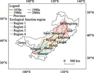
Figure 2 The FPE boundaries based on climate indicators in northern China
|
During different periods, both the shift ranges and change areas of the land-use-based boundary were less than those of the climate-based boundary, which indicated that the shift of the FPE caused by climate was greater than that by land use (Table 2, Figure 3). The land-use-based boundary experienced more extensive shifts in the northeast part (region 1) with the mean boundary shift distances of 18.07 km, 30.55 km and 24.38 km during the 1970s-1980s, 1980s-1990s, and 1990s-2000s, respectively. The slightest shifts happened in the northwest part (region 4) with the mean boundary shift distances of only 2.94 km, 5.02 km, and 3.56 km during different periods. Similar to the climate-based boundary, the area of the land-use-based boundary also underwent an increase of 2.54×10⁴ km2 during the 1970s-1980s. However, the area of the land-use-based boundary decreased by 0.52 km2 during the 1980s-2000s.
5 Discussion and Conclusion
|
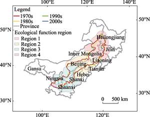
Figure 3 The FPE boundaries based on land
use in northern China
|
The climate-based boundaries in the dataset had similar scopes as those defined by Zhao et al.[1] and Liu et al.[18] using climate indicators. They also set the 400 mm isotype as the central line and the 300 mm isotype as the northwest boundary and used precipitation variability and the acidity index to modify the boundary. The southeast boundaries were similar to those defined by Li et al.[19] and Zhu et al.[5] based on the precipitation, precipitation variability, precipitation assurance rate, and wind speed. The boundaries all started in the Songnen Plain and ran through the west part of Jilin province, northwestern Liaoning and Hebei provinces, and northern Shaanxi and Shanxi provinces, ending in Gansu and Ningxia provinces. The land-use-based boundaries in our dataset were similar to those defined by Wu et al.[20], Wang et al.[21], and Ye et al.[22] using the area-percentages of both cropland and grassland in each grid cell. Wu et al.[20] proposed that the relative proportion of cropland, grassland and forest should be 1??0.5??1.5 in the FPE. Wang et al.[21] suggested that the FPE should satisfy two conditions: the area-percentage of cropland is between 15% and 35%, and the area-percentage of grassland is between 35% and 75%. Ye et al.[22] defined the boundaries by including the grid cells with area-percentage of cropland between 15% and 35%. Although the indicators and conditions used to define the FPE boundary in our dataset were slightly different from previous studies, the main scopes of the boundaries were similar and our dataset facilitated the modification of the previous boundaries.
Due to effects from both climate change and human activities, the frequent transformation of cropland and grassland has caused continuous shifts in climate-based boundary and land-use-based boundary[16]. Therefore, a more precise and reasonable delineation of the boundaries can provide basic data to support relevant research, especially studies on the relationships between climate change or human activities and shifts in the FPE boundary. However, due to the limited temporal coverage of remote sensing data, land-use-based boundaries in our dataset was based on the data from the end of each period. The delineation of climate-based boundaries was based on the mean values of climate indicators during each period. Hence, the FPE boundaries with higher temporal resolution need further study. The FPE is not only a transitional zone of natural factors such as climate, soil and elevation but also a transitional zone responding to social, economic, population and other human activities[11]. Therefore, integrated conditions and indicators considering both climate and human activities are urgently needed to delineate a more empirically robust FPE boundary.
Author Contributions
Shi, W. J. designed the overall plan; Shi, W. J. and Shi, X. L. designed the algorithms and model; Liu, Y. T. contributed to the data processing and wrote the data paper.
References
[1] Zhao, H. L., Zhao, X. Y., Zhang, T. H., et al. Boundary line on agro-pasture zigzag zone in North China and its problems on eco-environment [J]. Advance in Earth Sciences, 2002, 17(5): 739-747.
[2] Zhao, J., Li, X. Research progress on the farming-pastoral ecotone in China [J]. Pratacultural Science, 2009, 26(1): 94-99.
[3] Liu, J. H., Gao, J. X. Changes of land use and landscape pattern in the boundary change areas in farming- pastoral ecotone of northern China [J]. Transactions of the Chinese Society of Agricultural Engineering, 2008, 24(11): 76-82.
[4] Zhao, S. Q. Chabei, Chahar and Xilingol League—a survey of economic geography in a farming-pastoral transition zone [J]. Acta Geographica Sinica, 1953, 19(1): 43-60.
[5] Zhu, Z. D., Liu, S., Yang, Y. L. The possibilities and realities on re-management of desertified lands in the interdistributing areas for agricultural and graziery practices in northern China [J]. Scientia Geographica Sinica, 1984, 4(8): 197-206.
[6] Wang, J. A., Xu, X., Liu, P. F. Land use and land carrying capacity in ecotone between agriculture and animal husbandry in northern China [J]. Resources Science, 1999, 21(5): 19-24.
[7] Zhang, L. S. Study on the Historical Evolution of Chinese Living Environment (1) [M]. Beijing: China Ocean Press, 1993.
[8] Zhang, L. Y., Su, G. W. Proceedings of the national symposium on debris flow in the period of quaternary [C]. The regional characteristics of natural disasters in the marginal area of northern monsoon in China. Lanzhou: Gansu Culture Press, 1994.
[9] Wang, Z., Zhang, P. Y., Liu, X. L., et al. On the ecological sensitive zone in China [J]. Acta Ecologica Sinica, 1995, 15(3): 319-326.
[10] Tian, G. J., Shi, P. J. Research of environmental archaeology in the great wall zone of northern China [J]. Steppe Cultural Relics, 1997, (2): 44-51.
[11] Shi, X. L., Shi, W. J. Review on boundary shift of farming-pastoral ecotone in northern China and its driving forces [J]. Transactions of the Chinese Society of Agricultural Engineering, 2018, 34(20): 1-11.
[12] Shi, W. J., Liu, Y. T. Farming-pastoral ecotone boundaries dataset of northern China (1970-2010) [DB/OL]. Global Change Research Data Publishing & Repository, 2018. DOI: 10.3974/geodb.2018.05.05.V1.
[13] GCdataPR Editorial Office. GCdataPR data sharing policy [OL]. DOI: 10.3974/dp.policy.2014.05 (Updated 2017).
[14] Huang, Q., Xin, X. P., Zhang, H. B. Ecosystem-service-based regionalization of the grassland and agro-pastoral transition zone in northern China [J]. Acta Ecologica Sinica, 2010, 30(2): 350-356.
[15] Shi, W. J., Liu, Y. T., Shi, X. L. Development of quantitative methods for detecting climate contributions to boundary shifts in farming-pastoral ecotone of northern China [J]. Journal of Geographical Sciences, 2017, 27(9): 1059-1071.
[16] Shi, W. J., Liu, Y. T., Shi, X. L. Contributions of climate change to the boundary shifts in the farming- pastoral ecotone in northern China since 1970 [J]. Agricultural Systems, 2018, 161: 16-27.
[17] Shi, W. J., Liu, Y. T., Shi, X. L. Quantitative methods for detecting the impacts of climate change on the fluctuation of farming-pastoral ecotone boundaries in northern China [J]. Acta Geographica Sinica, 2017, 72(3): 407-419.
[18] Liu, J. H., Gao, J. X., Lv, S. H., et al. Shifting farming–pastoral ecotone in China under climate and land use changes [J]. Journal of Arid Environments, 2011, 75(3): 298-308.
[19] Li, S. K. Agro climatic regionalization of China [J]. Journal of Natural Resources, 1987, 2(1): 71-83.
[20] Wu, C. J., Guo, H. C. The Land Use of China [M]. Beijing: Science Press, 1994.
[21] Wang, J. A., Shi, P. J. The utilization of land resources and regional development strategies of farming- pastoral zone in Inner Mongolia [J]. Areal Research and Development, 1988, 7(1): 24-28.
[22] Ye, Y., Fang, X. Q. Expansion of cropland area and formation of the eastern farming-pastoral ecotone in northern China during the twentieth century [J]. Regional Environmental Change, 2012, 12(4): 923-934.