Analysis on the Eighth
Iteration of GEO Work Programme (2023-2025)
Fan, J. L1. Liu, C.2 * Wu, J. J. 3 Liu, Y. H.4 Li, L. M.2
1. National Satellite
Meteorological Center, Beijing 100081, China;
2. Institute of Geographic
Sciences and Natural Resources Research, Chinese Academy of Sciences, Beijing
100101, China;
3. Aerospace Information Research
Institute, Chinese Academy of Sciences, Beijing 101408, China;
4. Aerospace Hongtu Information
Technology Co., Ltd., Beijing 100089, China
Abstract: The
Secretary of Group of Earth Observation (GEO) released the third version of GEO
work program 2023?C2025
in December 2022. This is the eighth iteration of GEO work program since GEO
was established in 2005. Five action lines were listed at the GEO work program
2023?C2025, they were 5
flagships, 19 initiatives, 20 pilot initiatives, 4 regional GEOs and one
foundational task. Based on the statistics, the authors indicated that there
were 46 countries contributed to the flagships, in which, USA and Australia
contributed in all the five, China contributed in 3, Germany contributed in 4. Among the 19
Initiatives, USA contributed in 14, about 78% of total, China contributed in 6.
There were 47 countries contributed in 20 pilot initiatives, China in 9 just
behand USA in 10. The article analyzed the work program impacts, indicated that
the most value of earth observation lies in its long-term and continuous
nature; the content diversity of earth observation is another unique impact for
earth science and society, the international joint actions and cooperations are
the key to make the program success. The authors believe GEO Working Plan 2023?C2025 is GEO new milestone with its
unique vision, goals, and objectives. Of course, there is also an imbalance in
the layout and development of the work plan, mainly manifested in the existence
of a large amount of earth observation data and the wide application of these
data. Accelerating the processing and analysis of Earth observation data,
promoting the widespread application of data, and achieving greater ecological,
social, and economic benefits with new technology of artificial intelligent
should be a special concern in the next stage of GEO work plan.
Keywords: GEO; Eighth Iteration; work programme; 2023-2025
DOI: https://doi.org/10.3974/geodp.2023.03.01
CSTR: https://cstr.escience.org.cn/CSTR:20146.14.2023.03.01
1 Introduction
Since Group of Earth
Observation (GEO) was established in 2005, two decadal programs were made. The
first one from 2005 to 2015 was focused on the Global Earth Observation System
of Systems (GEOSS) which was for enhancing international data sharing and
interoperability of earth observation. The second one from 2016 to 2025 was focused on the GEO services through the implementation mechanisms,
including flagships, initiatives, foundational task, regional GEOs and a series
of activities. Not only decadal programs, the iterations in each programs were
identified. The Eighth Iteration of GEO Work Programme (2023-2025) is the update one in
the two decadal programs. The GEO secretary released the third version of the
eighth iteration of the GEO Work Programme 2023?C2025 (??GEO Work Plan?? for
short) in December 2022[1]. According
to the GEO Work Plan, flagships, initiatives, pilot initiatives, regional task
and foundational action were identified.
2 Action
Lines
Five action lines were
described in the GEO Work Plan 2023?C2025. They are: five flagships, 19
initiatives, 20 pilot initiatives, 4 regional GEOs and one foundational action.
2.1 Action Line 1:
Flagships
There are five GEO flagships in the GEO Work
Plan 2023?C2025, they are: GEO Biodiversity Observation Network, GEO Global Agricultural
Monitoring, Global Forest Observations Initiative, Global Observation System
for Mercury and GEO Land Degradation Neutrality. The national members and participating
organizations of contributors for these flagships are listed in Table 1.
Table
1 List of flagships of the GEO Working Plan
2023?C2025:
|
Code
|
Title
|
Short name
|
Contributors
|
|
F1
|
GEO Biodiversity Observation Network[2,3]
|
GEO-BON
|
Australia, Canada, Colombia,
Finland, Netherlands, Norway, USA; ITC, and ESA
|
|
F2
|
GEO Global Agricultural Monitoring[4]
|
GEOGLAM
|
Argentina, Australia, Belgium,
Brazil, Canada, Chile, China, Egypt, European
Commission, France, Germany, India, Indonesia, Italy, Japan, Malaysia,
Mexico, Morocco, Philippines, Poland, Russia, South Africa, Spain, Thailand,
Tunisia, Ukraine, UK, USA, Uruguay,
Vietnam, Zimbabwe; ESA, FAO, IIASA, ITC, RCMRD, WFP, and WMO
|
|
F3
|
Global Forest Observations Initiative[5]
|
GFOI
|
Australia, Germany, Japan,
Norway, Spain, UK, USA; CEOS, ESA, FAO, and The World Bank
|
|
F4
|
Global Observation System for Mercury[6]
|
GOS4M
|
Argentina, Australia, China,
Cote d??Ivoire, Czech Republic, Denmark, Finland, France, Germany, Greece, Russia,
Slovenia, South Africa, Sweden, Ukraine, UK, USA, Italy
|
|
F5
|
GEO Land Degradation Neutrality[7]
|
GEO-LDN
|
Australia, Brazil, Burkina
Faso, China, Denmark, European Commission, Finland,
France, Germany, Ghana, Italy, Japan, Kenya, Netherlands, Mexico,
Poland, Senegal, South Africa, Spain, Switzerland, Ukraine, UK, USA; ISESTEL,
AARSE, CI, UNCCD, FAO, EEA, EARSC, CEOS, and ESA
|
2.2 Action
Line 2: Initiatives
There are 19 initiatives in the GEO working
program 2023?C2025 they are??AquaWatch,
Data Integration and Analysis System, Digital Earth Africa, Earth Observations
for Ecosystem Accounting, Earth Observations for Health, Earth Observations for
Disaster Risk Management, Earth Observations for the Sustainable Development
Goals, GEO Blue Planet, GEO Capacity Building in North Africa, Middle East,
Balkans and Black Sea Region, GEO Global Water Sustainability, GEO Human
Planet, GEO Vision for Energy, GEO Wetlands, Geohazard Supersites and Natural
Laboratories, Global Drought Information System, Global Network for
Observations and Information in Mountain Environments, Global Observation
System for Persistent Organic Pollutants, Global Urban Observation and
Information, Global Wildfire Information System. The national members and
participating organizations of contributors for these initiatives are listed in
Table 2.
Table
2 list of initiatives of the GEO Working
Plan 2023?C2025
|
Code
|
Title
|
Short name
|
Contributors
|
|
I1
|
AquaWatch[8]
|
AQYAWATCH
|
Australia, Bangladesh, Belgium,
Germany, Ghana, Netherlands, Switzerland, UK, USA,
|
|
I2
|
Data Integration
and Analysis System[9]
|
DIAS
|
Indonesia, Japan, Philippines
|
|
I3
|
Digital
Earth Africa[10]
|
DE-AFRICA
|
Australia, Ghana, and South Africa;
OSS, AGRHYMET, GPSDD
|
|
I4
|
Earth
Observations for Ecosystem Accounting[11]
|
EO4EA
|
Canada, European Commission,
Mexico, Netherlands, USA; ESA, FAO, The World Bank, CI, EEA. ESRI
|
|
I5
|
Earth
Observations for Health[12]
|
EO4HEALTH
|
Canada, Costa Rica, Mexico, South
Africa, UK, USA, WHO, WMO, RCMRD, SICA/CCAD
|
|
I6
|
Earth
Observations for Disaster Risk Management[13]
|
EO4DRM
|
Argentina, Belgium, Canada, France,
Italy, Luxembourg, Switzerland, USA; ESA, FAO, CEOS
|
|
I7
|
Earth
Observations for the Sustainable Development Goals[14]
|
EO4SDG
|
Australia, China, Costa Rica,
European Commission, Germany, Greece, Japan, Kenya, Mexico, Namibia, Netherlands,
Norway, South Africa, Sweden, Switzerland, United Arab Emirates, UK, USA;
UNCCD, WDS, EARSC, ESA, i-BEC, IEEE, IIASA, UNOOSA, WHO, UNITAR, CEOS,
AGRHYMET
|
|
I8
|
GEO Blue
Planet[15]
|
GEO-BLUE-PLANET
|
France, European Commission, Ghana,
USA; IEEE, IOC, POGO
|
|
I9
|
GEO Capacity
Building in North Africa, Middle East, Balkans and Black Sea Region
|
GEO-CRADLE
|
Cyprus, Greece, Italy, Spain,
Ukraine
|
|
I10
|
GEO Global
Water Sustainability[16]
|
GEOGLOWS
|
European Commission, France, Japan,
Switzerland, USA; RCMRD, CI, The World Bank, WMO
|
|
I11
|
GEO Human
Planet[17]
|
HUMAN-PLANET
|
China, European Commission,
Germany, Greece, Ireland, Netherlands, UK, USA; EU SatCen
|
|
I12
|
GEO Vision
for Energy[18]
|
GEO-VENER
|
Australia, Denmark, France,
Germany, Greece, Switzerland, USA; ESA
|
|
I13
|
GEO Wetlands[19]
|
GEO-WETLANDS
|
Australia, Austria, Denmark,
France, Germany, Greece, Japan, Netherlands, Spain, Sweden, UK, USA; IWMI,
ESA, CI
|
|
I14
|
Geohazard
Supersites and Natural Laboratories[20]
|
GSNL
|
Argentina, Canada, Chile, China,
Ecuador, Germany, Greece, Iceland, Italy, Japan, New Zealand, Portugal,
Spain, Sweden, Switzerland, Turkey, USA; CEOS, EPOS
|
|
I15
|
Global
Drought Information System[21]
|
GDIS
|
Australia, Austria, Brazil,
European Commission, Korea, Paraguay, Slovenia, USA; ECMWF, WMO
|
|
I16
|
Global Network
for Observations and Information in Mountain Environments[22]
|
GEO-MOUNTAINS
|
Austria, European Commission,
Italy, Switzerland, UK, USA; MRI, ICIMOD
|
|
I17
|
Global
Observation System for Persistent Organic Pollutants[23]
|
GOS4POPs
|
Australia, Brazil, Cameroon, China,
Costa Rica, Czech Republic, Denmark, Greece, Italy, Japan, Kenya, Morocco,
Norway, Russia, Slovenia, Spain, Sweden, Uruguay,
|
|
I18
|
Global Urban
Observation and Information[24]
|
GUOI
|
Austria, Brazil, Canada, China,
Germany, Greece, India, Japan, Pakistan, Spain, USA; GRSS
|
|
I19
|
Global
Wildfire Information System[25]
|
GWIS
|
Argentina, Australia, Brazil,
Canada, China, European Commission, Germany, Greece, Indonesia, Mexico,
Netherlands, New Zealand, Portugal, South Africa, Spain, UK, USA, Zimbabwe;
ECMWF, ESA, FAO
|
2.3 Action Line 3: Pilot
Initiatives
There are 20 pilot initiatives in the GEO
work plan 2023?C2025, including two catalogues, one is the community activities
accepted as pilot initiatives, and the other one is new pilot initiatives.
2.3.1 Pilot Initiatives
There are 15 communities accepted as pilot
initiatives. The titles, GEO members and participating organizations of
contributors for these pilot initiatives are listed in Table 3.
2.3.2 New Proposals of
Pilot Initiatives
There are five new proposals of pilot
initiatives. The titles, GEO members and participating organizations of
contributors for these pilot initiatives are listed in Table 4.
Table
3 List of community activities accepted as
pilot initiatives of the GEO Working Plan 2023?C2025
|
Code
|
Title
|
Short name
|
Contributors
|
|
CP1
|
ArcticGEOSS[26]
|
ARCTIC-GEOSS
|
Canada, Finland, Germany,
Italy, Netherlands, Norway, Portugal, UK, USA; SAON
|
|
CP-2
|
Digital Earth Pacific[27]
|
DE-PACIFIC
|
Australia, Tonga, USA; SPC,
CEOS, WFP
|
|
CP-3
|
Earth Observations for multi-scale monitoring of mining impacts[28]
|
EO4MIN
|
China, Czech Republic,
France, Germany, Greece, Israel, Pakistan, Portugal, Switzerland; UN
Environment, EuroGeoSurveys
|
|
CP-4
|
Earth Observations for the Water-Energy-Food Nexus[29]
|
EO4WEF
|
China, Norway, Sweden, USA
|
|
CP-5
|
Forest Biomass Reference System from Tree-by-Tree Inventory Data[30]
|
GEO-TREES
|
Austria, Brazil, France,
Germany, UK, USA; ESA, IIASA
|
|
CP-6
|
GEO Citizen Science[31]
|
GEO-CITSCI
|
Australia, Austria, European
Commission, Greece, European Commission, Norway, Spain, UK, USA; IHE, IIASA,
RCMRD
|
|
CP-7
|
GEO Essential Variables[32]
|
GEO-EV
|
Belgium, Spain, Switzerland,
USA
|
|
CP-8
|
Geodesy for the Sendai Framework[33]
|
GEODESY4SENDAI
|
Australia, China, France,
Germany, Italy, Japan, Switzerland, Tajikistan, Tonga, USA; IAG, IUGG
|
|
CP-9
|
Global Ecosystems and Environment Observation Analysis Research
Cooperation[34]
|
GEOARC
|
Australia, China, Israel,
Russia
|
|
CP-10
|
Global Vegetation Pest and Disease Dynamic Remote Sensing Monitoring
and Forecasting[35]
|
GEO-PDRS
|
China, Italy, Pakistan, UK;
FAO, GBIF, CABI
|
|
CP-11
|
In-Situ Observations and Applications for Ecosystem Status of China
and Central Asia[36, 37]
|
IN-SITU-ESC
|
China, Kazakhstan,
Tajikistan; UNEP
|
|
CP-12
|
Night-Time Light Remote Sensing for Sustainable Development Goals[38]
|
NIGHT-LIGHT
|
China, Uzbekistan; UNITAR
|
|
CP-13
|
Open Earth Alliance
|
OEA
|
USA
|
|
CP-14
|
Space and Security
|
SPACE-SECURITY
|
Germany; ESA,
EuroGeoSurveys, IHE, WFP, EUSatCen
|
|
CP-15
|
Urban Heritage Climate Observatory[39]
|
UHCO
|
Austria, Canada, Sebruce,
Ecuador, France, Germany, Greece, India, Israel, Italy, South Africa, Spain,
UK, USA; Eurisy, MKF, UNU-EHS, ECMWF, ACCREC
|
Table
4 List of new proposals of pilot initiatives
of the GEO Working Plan 2023?C2025
|
Code
|
Title
|
Short name
|
Contributors
|
|
NP-1
|
Antarctic Ice Sheet Monitoring
|
AIS-MONITORING
|
Australia, Belgium, China,
Denmark, France, Germany, Italy, New Zealand, Norway, Sweden, UK, USA
|
|
NP-2
|
Earth Observations for Global Typical Karst
|
EO4KARST
|
Brazil, China, Indonesia,
Philippines, Serbia, Slovenia, South Africa, Thailand, Zimbabwe;
International Research Centre on Karst under the auspices of UNESCO
|
|
NP-3
|
GEO Cold Regions Initiative
|
GEOCRI
|
Canada, China, Finland,
Germany, Italy, Japan, Netherlands, Norway, USA
|
|
NP-4
|
Global Geochemical Observation Network and Digital Chemical Earth
|
CHEMICAL-EARTH
|
Argentina, Brazil, Cambodia,
China, Colombia, Ireland, Mongolia, Peru, Russia, Thailand, Turkey; ICGG
|
|
NP-5
|
Global Products of Common Essential Variables from Multiple Satellite
Data
|
GEO-EV-PRODUCTS
|
Australia, China, EU,
France, Spain, UK, USA
|
2.4 Regional GEOs
According to the regions of the world, there
were four regional GEOs, they are: African Group on Earth Observations,
Americas Group on Earth Observations, Asia-Oceania Group on Earth Observations
and European Group on Earth Observations. The contributors of each of the regional
GEOs are listed in Table 5.
Table
5 GEO Working Plan 2023?C2025: list of
regional GEOs
|
Code
|
Title
|
Short name
|
Contributors
|
|
R1
|
African Group on Earth Observations
|
AFRIGEO
|
Congo, Egypt, Gabon, Ghana,
Kenya, Madagascar, Morocco, Nigeria, Senegal,
South Africa, Uganda, Zimbabwe; RCMRD, ASREN, COMIFAC, EIS-AFRICA,
OSS, UNECA, ARCSSTE-E, AGRHYMET; Swaziland
|
|
R2
|
Americas Group on Earth Observations
|
AMERIGEO
|
USA, Argentina, Brazil,
Canada, Chile, Colombia, Costa Rica, Ecuador, Panama, Mexico, Paraguay, Peru,
Salvador, Guatemala, Nicaragua; SICA/CCAD, CLARA, ESRI
|
|
R3
|
Asia-Oceania Group on Earth Observations
|
AOGEO
|
China, Australia, South
Korea, France, India, Indonesia, Japan, Malaysia, USA, Philippines, Thailand,
UK, Vietnam; FAO, IOC
|
|
R4
|
European Group on Earth Observations
|
EUROGEO
|
European Commission, European
Caucus including European GEO Members and Participating Organizations
|
3 Statistics on Contributors of
GEO members in GEO Work Plan 2023?C2025
3.1 Contributors in
Flagships
There were 45 GEO members contributed to the
GEO Flagships. They are: USA, Australia, Germany, China, Finland, South Africa,
Japan, Italy, UK, Ukraine, Spain, EU, Norway, Mexico, Canada, Netherlands,
Russia, Denmark, Poland, Brazil, Argentina, Chile, Vietnam, Indonesia, India,
Greece, Uruguay, Tunisia, Thailand, Slovenia, Senegal, Switzerland, Sweden,
Morocco, Malaysia, Kenya, Côte d??Ivoire, Zimbabwe, Czech Republic, Ghana,
Colombia, Philippines, Burkina Faso, Belgium, and Egypt.
Among them, the USA and Australia contributed
in all 5 flagships, Germany contributed in 4 flagships, 8 countries including
China contributed in 3, 9 countries including Brazil contributed in 2. China
was missing out on GEO Biodiversity Observation Network and Global Forest Observations
Initiative (Figure1).
3.2 Contributors in Initiatives
There were 52 countries listed in the
contributors of the 19 GEO initiative, including USA, Greece, EU, Germany,
Australia, UK, Switzerland, Japan, China, Canada, Spain, Netherlands, Italy,
Sweden, South Africa, Mexico, France, Brazil, Austria, Ghana, Costa Rica,
Denmark, Argentina, Indonesia, New Zealand, Slovenia, Portugal, Norway, Kenya,
Belgium, Chile, India, Uruguay, Ukraine, Turkey, Cyprus, Namibia, Morocco,
Bangladesh, Luxembourg, Cameron, Zimbabwe, Czech Republic, South Korea,
Philippines, Ecuador, Russia, Iceland, Paraguay, Pakistan, Ireland, United Arab
Emirates. Among them, the USA contributed in a maximum of 15 initiatives.
Secondly, Greece contributed in 9 initiatives; the European Union, Germany, and
Australia in 8 respectively. UK, Switzerland, and Japan each contributed in 7.
China contributed in 6, about one-third of the total initiatives (Figure2).
3.3 Contributors in Pilot Initiatives
There were 48 countries to contribute 20 pilot initiatives, including
USA, China, Germany, UK, Australia, France, Italy, Norway, Switzerland, Spain,
Greece, Austria, Brazil, Canada, EU, Israel, Pakistan, Belgium, Russia,
Finland, South Africa, Portugal, Japan, Sweden, Tajikistan, Thailand, Tonga,
Argentina, Ireland, Denmark, Ecuador, Philippines, Colombia,

Figure 1 Statistics of GEO
member contributing in two or more GEO flagships

Figure 2 Statistics of GEO member
contributing in two or more GEO initatives
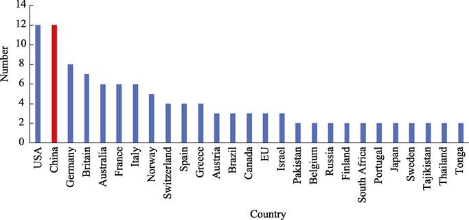
Figure 3 Statistics of GEO member
contributing in two or more GEO pilot initiatives
Kazakhstan, Netherlands, Cambodia Czech
Republic, Zimbabwe, Mongolia, Peru, Serbia, Cyprus, Slovenia, Turkey, Uzbekistan,
New Zealand, India, Indonesia. Among them, USA and China were most active countries,
who contributed in 12 pilot initiatives individually, and Germany in 8, UK in 7
separately (Figure3).
3.4 Contributors in Regional GEOs
Almost of all of GEO members joined the regional
GEOs, since the regional GEO groups were more focused on the regional issues
and thematic priorities which the region concerned. South Africa, USA, China,
and European Commission played the coordinating roles at the African Group,
Americas Group, Asia-Oceania Group and European Group.
3.5 Contributors in Foundational Task
The GEO foundational
task was the most important task for GEO progresses. It covered five aspects,
including GEO engagement priorities coordination; GEOSS data, information, and
knowledge resources; GEOSS Infrastructure development; GEO work programme
support; and GEO secretariat operations. The GEO foundational task was operated
by GEO secretariat with collaborative teams from GEO communities.
4 Summary
GEO work plan 2023?C2025 is a joint, opening,
and international program, engaged in multilateral cooperation, with over 70
GEO members. This includes the adoption of a multilateral cooperation mechanism
in project implementation, and the leading countries and units of the project
also reflect the characteristics of multilateralism. The member countries and
organizations participating in the project further demonstrate the
characteristics of multilateral participation and contribution. For example,
the flagship project of GEOBLAM attracted contributors of 30 GEO members and 7
international organizations.
The most value of Earth Observation lies in
its long-term and continuous nature. Although GEO work plan 2023?C2025 has
launched at different year, however, adhering to long-term observation is a
common characteristic. For example, the GEO Biodiversity Observation Network is
a long-term plan that has undergone 15 years of multilateral cooperation
framework.
The content diversity of earth observation is
the most prominent characteristics of GEO work plan 2023?C2025. The content
diversity of earth observation can be clustered into five catalogues:
(1) Global Observation Plan on earth factors,
such as: GEO BON, GEOGLAM, GFOI, AQUAWATCH, GEO-BLUE-PLANET, GEOGLOWS, GOS4M,
GEO-LDN, GEO-TREES, HUMAN-PLANET, GOS4POPs,
CHEMICAL EARTH, GEO-VENER, GEO MOUNTAINS,
EO4KARST, EO4MIN, UHCO, GUOI, GEO-WETLANDS.
(2) Observation plan for
key areas, such as??DE-PACIFIC, DE-AFRICA, AIS-MONITORING, ARCTIC-GEOSS, GEOCRI, IN
SITU-ESC.
(3) Earth observation program with a focus on
natural disasters, such as: GSNL, GEODESY4SENDAI, EO4DRM, GEO-PDRS, GDIS, GWIS.
(4) Observation and analysis plan, such as??EO4SDG, NIGHT-LIGHT, EO4HEALT, DIAS, EO4EA,
EO4WEF, GEOARC, GEO-EV-PRODUCTS, SPACE-SECURITY, SPACE- SECURITY.
(5) Development cooperation and capacity
buildings, such as??OEA, GEO-CITSCI, and GEO capacity
building.
The implementation of GEO work plan 2023?C2025
had focused on two levels: global and regional levels. The implementation of
regional level was divided into two types. One is in four geographical regions:
Africa GEO, Europe GEO, Asia Pacific GEO, and the Americas GEO. And the other
one was by joint observation methods in crossing regions. For example:
Antarctica, Arctic, cold regions, Central Asia, etc.
In summary, the GEO Working Plan 2023?C2025 is
GEO new milestone plan with its unique vision, goals, and objectives. Not only,
and a clear implementation roadmap is included. It is of great significance for
the implementation of GEO??s second decade development strategy since GEO was
established in 2005. Of course, there is also an imbalance in the layout and
development of GEO??s 2023?C2025 implementation plan, mainly manifested in the
existence of a large amount of Earth observation data and the wide application
of these data. The imbalance between the two is a common problem in the current
GEO project execution process. Accelerating the processing and analysis of
Earth observation data, promoting the widespread application of data, and
achieving greater ecological, social, and economic benefits with new technology
of artificial intelligent should be a special concern in the next stage of GEO
work plan.
Author Contributions
Fan, J. L. designed the framework of the paper. Wu, J.
J., Liu, Y. H. and Li, L. M. collected and processed the statistical data of
GEO. Liu, C. wrote the paper.
Conflicts of Interest
The
authors declare no conflicts of interest.
References
[1]
GEO Work Programme: 2023?C2024
Summary document (Version 3) [Z]. December 2022.
[2]
Perrings, C., Duraiappah, A.,
Larigauderie, A., et al. The biodiversity
and ecosystem services science-policy interface [J]. Science, 2011, 331: 1139?C1140. DOI:10.1126/science.1202400.
[3]
Hughes, A. C. The Post?C2020 global
biodiversity framework: how did we get here, and where do we go next? [J]. Integrative Conservation, 2023, 2: 1?C9. https://doi.org/10.1002/inc3.16.
[4]
Becker-Reshef, I., Justice, C.,
Whitcraft, A. K., et al. Geoglam: a GEO
initiative on global agricultural monitoring [C]. IEEE International Geoscience
and Remote Sensing Symposium, IEEE, 2018.
[5]
Mitchell, A., Hoekman, D. H.
Global Forest Observations Initiative (GFOI)?Dreview of priority research &
development Topics [Z]. 2013. https://www.fao.org/gfoi/home/it/.
[6]
Cinnirella, S., Damore, F.,
Mazzetti, P., et al. A spatial data
infrastructure for the Global Mercury Observation System [C]. International
Conference on Heavy Metals in the Environment, 2014.
[7]
Sayah, M. A., Abdallah, C.,
Khouri, M., et al. Role of GIS in the
application of the Land Degradation Neutrality Concept (LDN) [Z]. 2018.
[8]
Greb, S., Odermatt, D., Smail, E.,
et al. Advanced techniques for
monitoring water quality using Earth Observation [Z].
https://www.geoaquawatch.org/wp-content/uploads/ 2018/04/AquaWatch_lowres.pdf.
[9]
Ikoma,
E., Kitsuregawa, M. DIAS?Dearth environment data integration and analysis system [J]. Communications of the ACM, 2023, 66(7):
85?C86.
[10]
Yuan,
F., Lewis, A., Leith, A., et al.
Analysis ready data for Africa [C]. 2021 IEEE International Geoscience and Remote
Sensing Symposium IGARSS, IEEE, 2021: 1789?C1791.
[11]
Buchhorn,
M., Smets, B., Danckaert, T., et al.
Establishing a reference tool for ecosystem accounting in Europe, based on the INCA methodology [J]. One Ecosystem, 2022, 7: e85389.
[12]
Lehmann,
A., Mazzetti, P., Santoro, M., et al.
Essential earth observation variables for high-level multi-scale indicators and
policies [J]. Environmental Science & Policy, 2022, 131: 105?C117.
[13]
Tay, C., Yun, S., Chin, S., et al. Rapid flood and damage mapping
using synthetic aperture radar in
response to typhoon Hagibis, Japan [J]. Scientific
Data, 2020, 7: 100. DOI: https://doi.org/10. 1038/s41597-020-0443-5,
March, 2020.
[14]
Kavvada,
A., Metternicht, G., Kerblat, F., et al.
Towards delivering on the sustainable development goals using earth
observations [J]. Remote Sensing of
Environment, 2020, 247: 111930.
[15]
Smail,
E. A., DiGiacomo, P. M., Seeyave, S., et
al. An introduction to the ??Oceans and Society: Blue Planet??initiative [J].
Journal of Operational Oceanography,
2019, 12(sup2): S1?CS11.
[16]
Rothman,
D. S. The development of the GEO-4 scenarios and their basic storylines [Z]. Issues in Global Water System
Research, 2007: 24.
[17]
Pesaresi,
M., Melchiorri, M., Siragusa, A., et al.
Atlas of the human planet
2016 [Z]. Mapping human presence on earth with the global human settlement
layer, 2016.
[18]
Hamm,
S. G., Augustine, C. R., Tasca, C., et al.
An overview of the US Department of Energy??s GeoVision Report [Z]. 2019.
[19]
Strauch,
A., Geller, G., Grobicki, A., et al.
Towards a global wetland observation system: the GEO-wetlands initiative [Z].
Prague, Czech Republic, 2016: 1?C7.
[20]
Salvi,
S. The GEO Geohazard Supersites and Natural Laboratories-GSNL 2.0: improving
societal benefits of geohazard science [C]. EGU General Assembly Conference Abstracts, 2016: EPSC2016-6969.
[21]
Heim,
R. R., Brewer, M. J. The global drought monitor portal: The foundation for a
global drought information system [J]. Earth
interactions, 2012, 16(15): 1?C28.
[22]
Adler,
C., Palazzi, E., Kulonen, A., et al.
Monitoring mountains in a changing world: New horizons for the Global Network
for Observations and Information on Mountain Environments (GEO-GNOME) [J]. Mountain Research and Development, 2018, 38(3): 265?C269.
[23]
Pike-Thackray,
C. M. An uncertainty-focused approach to modeling the atmospheric chemistry of
persistent organic pollutants [D]. Massachusetts Institute of Technology, 2016.
[24]
Prakash,
M., Ramage, S., Kavvada, A., et al.
Open Earth observations for sustainable urban development [J]. Remote sensing, 2020, 12(10): 1646.
[25]
Short,
K. C. A spatial database of wildfires in the United States, 1992?C2011 [J]. Earth System Science Data, 2014, 6(1):
1?C27.
[26]
Doug, N. Arctic Spatial data
infrastructure?Da base for arctic applications [J]. GIM international, 2013, 27(7):45?C45.
[27]
Craglia,
M., de Bie, K., Jackson, D., et al.
Digital Earth 2020: towards the vision for the next decade [J]. International Journal of Digital Earth,
2012, 5(1): 4?C21.
[28]
Thiele,
S. T., Lorenz, S., Kirsch, M., et al.
Multi-scale, multi-sensor
data integration for automated 3-D geological mapping [J]. Ore Geology Reviews, 2021, 136: 104252.
[29]
McNally,
A., McCartney, S., Ruane, A. C., et al.
Hydrologic and agricultural earth observations and modeling for the water-food
nexus [J]. Frontiers in Environmental
Science, 2019, 7: 23.
[30]
Haapanen,
R. Feature Extraction and Selection in Remote Sensing-Aided Forest Inventory [M].
Dissertationes Forestales, 2014.
[31]
Trojan,
J., Schade, S., Lemmens, R., et al.
Citizen science as a new approach in geography and beyond: review and
reflections [J]. Moravian Geographical
Reports, 2019, 27(4): 254?C264.
[32]
Kissling,
W. D., Ahumada, J. A., Bowser, A., et al.
Building essential biodiversity variables (EBVs) of species distribution and abundance
at a global scale [J]. Biological reviews,
2018, 93(1): 600?C625.
[33]
Wannous,
C., Velasquez, G. United Nations Office for disaster risk reduction
(unisdr)??unisdr??s contribution to science and technology for disaster risk
reduction and the role of the international consortium on landslides (ICL) [C]//Advancing
Culture of Living with Landslides: Volume 1, ISDR-ICL Sendai Partnerships, 2015?C2025. Springer
International Publishing, 2017: 109?C115.
[34]
Schmidt,
M. C., Veile, J. W., M??ller, J. M., et al.
Ecosystems 4.0: redesigning global value chains [J]. The International Journal of Logistics Management, 2021, 32(4):
1124?C1149.
[35]
Dong,
Y., Xu, F., Liu, L., et al. Automatic
system for crop pest and disease dynamic monitoring and early forecasting [J]. IEEE Journal of Selected Topics in Applied
Earth Observations and Remote Sensing, 2020, 13: 4410?C4418.
[36]
Zhang,
J., Di, L., Chen, Z. N., et al. In Situ Sample Dataset of Stem Sap Flow
of Robinia pseudoacacia Plantation on the Loess Plateau [J/DB/OL]. Digital Journal of Global Change Data
Repository, 2019. https://doi.org/10.3974/geodb.2019.06.17.V1.
[37]
Zhang,
J., Di, L., Chen, Z. N., et al. In Situ sample dataset of stem sap flow
of Robinia pseudoacacia plantation in the Loess Plateau [J]. Journal of Global Change Data & Discovery, 2020, 4(1): 60?C67. DOI:
10.3974/geodp.2020.01.09.
[38]
Kondmann,
L., Zhu, X. X. Under the rada?Dauditing fairness in ML for humanitarian mapping [OL].
arXiv preprint arXiv:2108.02137, 2021.
[39]
El-Bastawissi,
I. Y., Raslan, R., Mohsen, H., et al.
Conservation of Beirut??s urban heritage values through the historic urban
landscape approach [J]. Urban Planning,
2022, 7(1): 101?C115.