Methodology
for 1-km Raster Dataset of Annual Soil Erosion Modulus in Southwestern
Mountainous Region of China (2000-2015)
Wang,
J. Y.1,2 Zhu, Y. Q.2,3 Chen, P. F.2*
1. School of Architecture
Engineering, Shandong University of Technology, Zibo 255000, China;
2. State Key Laboratory of
Resources and Environment Information System, Institute of Geographic Sciences
and Natural Resources Research, Chinese Academy of Sciences, Beijing 100101, China;
3. Jiangsu Center for
Collaborative Innovation in Geographical Information Resource Development and
Application, Nanjing 210023, China
Abstract:
The southwestern mountainous region of China
covers Sichuan, Chongqing, Yunnan, and Guizhou provinces and cities and is an
ecologically fragile area in this country. The construction of a long-term soil
erosion dataset in the southwestern mountainous region is of great significance
for analyzing changes in the ecological environment under long-term
human-natural interactions and the formulation of sustainable development policies.
However, there is still a lack of long-term sequences, unified formats, and
fully shared datasets for soil erosion in the southwestern mountainous region.
Therefore, the author collected precipitation data, soil data, digital
elevation data, land-cover data, and vegetation index data from 2000 to 2015
and unified them to the same scale after a format conversion, projection
conversion, and spatial scale matching. A revised soil-loss model (The Revised
Universal Soil Loss Equation, RUSLE) was used to calculate an annual soil
erosion dataset (2000?C2015) with a 1-km grid in the southwestern mountains (Yunnan,
Guizhou, Sichuan, and Chongqing); this dataset can provide support for relevant
research. The dataset is in .tif and .shp format, and the data size is 109 MB.
Keywords: the southwestern mountainous
region of China; mountainous region; soil erosion
modulus; RUSLE model; 1 km
Dataset Availability Statement:
The
dataset supporting this paper was published and is accessible through the Digital Journal of Global
Change Data Repository at
https://doi.org/10.3974/geodb.2021.04.04.V1.
1 Introduction
The southwestern mountainous region of China (Sichuan,
Chongqing, Yunnan, and Guizhou) is located in the hinterlands. Due to its
special topography, geological conditions and human activities, the ecological
environment of this region is fragile and faces the problem of ??rocky
desertification?? caused by severe soil erosion[1?C3]. Current
research on soil erosion has mainly focused on a single year at the county scale,
and there is a lack of studies at the medium- and long-term scales. Dynamic and
systematic studies on areas with large spatial spans have seriously affected
the planning of the regional ecological environment[4].
The
soil erosion modulus is an important indicator used to measure the status of
soil erosion. Wischmeier et al.
established the estimation model of the soil erosion modulus USLE (Universal
Soil Loss Equation,1958)[5]. The model is relatively simple and
contains only two independent variables, namely, the slope length and slope.
The USLE model only considers single-factor effects and has a defect in that it
is only suitable for gentle slopes and cannot describe the physical process of
soil erosion[6]. With the development of artificial rainfall test
technology, people??s understanding of the mechanisms of soil erosion continues
to improve. In 1992, Rernard et al.
proposed an improved soil erosion modulus estimation model called the Revised
Universal Soil Loss Equation (RUSLE, 2019)[7] by integrating the
USLE and the erosion conceptual model established by Meyer and Forester. The
RUSLE model has a clearer physical meaning than the USLE, and the prediction
accuracy of the RUSLE is greatly improved. It is currently the most widely used
soil erosion modulus estimation model[8,9].
At
present, the only soil erosion modulus dataset covering the southwestern
mountain area that has been shared is the soil erosion data product provided by
the cloud platform from the geographical monitoring of national conditions;
however, this dataset only contains the soil erosion modulus data of each
province in China in 2005 in its number of data. This dataset cannot meet the
needs of analyses concerning soil erosion changes in the southwestern
mountainous areas regarding ecological engineering construction, regional
economic development or climate change. Therefore, based on the RUSLE model,
this paper produced a raster dataset with a soil erosion modulus of 1 km in the
southwestern mountainous region from 2000 to 2015.
2 Metadata of the Dataset
The metadata of 1 km raster dataset of annual soil erosion
modulus in southwestern mountainous region of China (2000?C2015)[10] is
summarized in Table 1. It includes the full name, short name, authors, year,
temporal resolution, spatial resolution, data format, data size, data files,
data publisher, and data sharing policy of the dataset, etc.
3 Methods
3.1 Algorithm Principle
The soil erosion modulus in the RULSE model is calculated
by using precipitation data, soil data, topography data, NDVI data and
land-cover data [12], as shown in Equation (1):
A=R??K??LS??C??P (1)
where A is the
soil erosion modulus (tžhm?C2ža?C1); R
is the rainfall erosivity factor (MJžmm hm?C2žh?C1ža?C1); K
is the soil erodibility factor (tžhžMJ?C1žmm?C1); LS
is the slope length and slope factor (dimensionless); C is the surface vegetation cover and management factor
(dimensionless); and P is the water
and soil conservation measure factor (dimensionless).
(1)
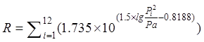
Determination of the rainfall erosivity factor
The rainfall erosivity
factor is calculated using Wischmeier??s Eqution[13]. This equation
considers both the total annual precipitation and monthly precipitation
intensity, as shown in Equation (2).
Table 1 Metadata summary of 1 km raster dataset
of annual soil erosion modulus in southwestern mountainous region of China
(2000?C2015)
|
Item
|
Description
|
|
Dataset
full name
|
1 km
raster dataset of annual soil erosion modulus in southwestern mountainous
region of China (2000?C2015)
|
|
Dataset
short name
|
SoilErosionSouthWestChina_2000-2015
|
|
Authors
|
Wang,
J. Y., Shandong University of Technology, wangjy766@sina.com
Zhu,
Y. Q. L-6116-2016, Institute of
Geographic Sciences and Natural Resources Research??Chinese
Academy of Sciences, zhuyq@igsnrr.ac.cn
Chen,
P. F. D-7136-2019, Institute of Geographic Sciences and Natural Resources
Research??Chinese Academy of Sciences,
pengfeichen@igsnrr.ac.cn
|
|
Geographical
region
|
The
mountainous region of southwestern China: 21??N-35??N,
97??E-111??E
|
|
Year
|
2000-2015
Temporal resolution year
|
|
Spatial
resolution
|
1 km Data
format .tif, .shp
|
|
Data
size
|
109
MB (52.5 MB after compression)
|
|
Data
files
|
The
dataset consists of 72 files. The file name is composed of a+year, and the
last four digits are the year
|
|
Foundation(s)
|
Chinese
Academy of Sciences (XDA23100100)
|
|
Data
publisher
|
Global Change Research Data Publishing &
Repository, http://www.geodoi.ac.cn
|
|
Address
|
No.
11A, Datun Road, Chaoyang District, Beijing 100101, China
|
|
Data
sharing policy
|
Data from
the Global Change Research Data Publishing & Repository includes metadata, datasets
(in the Digital Journal of Global Change Data Repository), and
publications (in the Journal of Global Change Data & Discovery). Data sharing policy
includes: (1) Data are openly available and can be freely downloaded via
the Internet; (2) end users are encouraged to use Data subject to
citation; (3) users, who are by definition also value-added service
providers, are welcome to redistribute Data subject to written permission
from the GCdataPR Editorial Office and the issuance of a Data redistribution
license; and (4) if Data are used to compile new
datasets, the ??ten percent principal?? should be followed such that Data
records utilized should not surpass 10% of the new dataset contents, while sources
should be clearly noted in suitable places in the new dataset[11]
|
|
Communication
and searchable system
|
DOI,
DCI, CSCD, WDS/ISC, GEOSS, China GEOSS, Crossref
|
 (2)
(2)
The above equation contains the monthly precipitation and annual
precipitation representing each month.
(2)
Determination of the soil erodibility factor
The soil erodibility
factor is a comprehensive manifestation of soil resistance to erodibility, and
different soil types have different values. The greater the value of the soil
erodibility factor is, the greater the possibility of soil erosion, and vice
versa. This study chooses the EPIC model formula proposed by Sharply and
Williams to calculate the soil erodibility factor[14]. This
algorithm considers both the soil organic carbon content and soil type, as
shown in Equation (3):
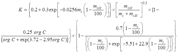 (3)
(3)
where, ms, msilt, mc, and orgC are the contents of sand, powder, clay and organic carbon,
respectively, in units of %.
(3)
Determination of the slope factor
The slope factor is
calculated using the formulas of McCool et
al.[15] and Liu Baoyuan[16], as shown in Equation
(4):
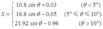 (4)
(4)
where q is the slope of the ground.
 (5)
(5)
 (6)
(6)
(4)
Determination of the vegetation cover management factor C and soil and water conservation measure factor P
The related research
results of other scholars [17] was consulted to determine the C and P values of various types of land cover, as shown in Table 2.
The C factor refers to the assignment of surface vegetation coverage
factors[18], and the P
factor refers to the assignment of soil and water conservation measure factors[19].
Table 2 Assignment of C and P factors for
different land-cover types
|
Land-cover type
|
C factor assignment
|
P factor assignment
|
|
Woodland
|
0.006
|
1
|
|
Grassland
|
0.03
|
0.8
|
|
Dry land
|
0.31
|
0.4
|
|
Paddy field
|
0.12
|
0.01
|
|
Water body
|
0
|
0
|
|
Other land
|
0
|
0
|
3.2 Technical Route
The
technical route of the dataset construction is shown in Figure 1. The route
mainly includes two parts: data collection and preprocessing, and data
simulation.
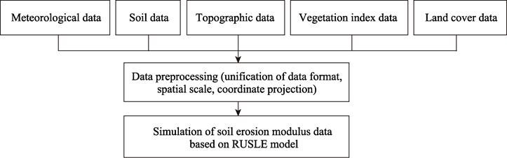
Figure 1 Technology roadmap of the dataset development
3.2.1 Data Collection and Processing
(1) The precipitation data come from the ??China regional high
temporal and spatial resolution ground meteorological factor driven dataset??[20]
of the National Qinghai-Tibet Plateau Science Data Center, with a spatial resolution of 1 km and a
temporal resolution of 3 hours. This study converts the data into 1-km monthly
average precipitation data through calculations.
(2) The soil data in 1 km resolution is taken from the
China Soil Data Set (v1.1)[21] of the World Soil Database (HWSD) of
the National Qinghai-Tibet Plateau Science Data Center and is spatially resolved.
(3) The DEM data adopt 30-m resolution SRTM data.
(4) The NDVI data come from the 1-km resolution product
(MOD13A3)4.
(5) The 2000 land-cover data are taken from the AVHRR
land-cover data product, which is based on AVHRR data from 1981 to 1994. The
land-cover classification method used is the classification method of the
University of Maryland5. After 2000, the land-cover data use the
land-cover data product corresponding to MODIS (MCD12Q1). When using MODIS data, the University of
Maryland classification method is also used.
(6) The boundary data come from 2015 China provincial
boundary data from the Resource and Environmental Science and Data Center of the Institute of Geographic Sciences and
Natural Resources Research, Chinese Academy of Sciences.
3.2.2 Data Modeling
The above preprocessed data are used as input and the
production of related datasets based on the RULSE model is realized.
4 Data Results and Validation
4.1 Data Composition
The dataset consists of the soil erosion modulus data of the
southwestern mountainous region from 2000 to 2015 and contains 1-km raster data
of annual soil erosion in the southwestern mountainous region from 2000 to
2015.
4.2 Data Products
Comparing the soil erosion modulus data of various years,
the distribution of the soil erosion modulus in southwestern mountainous areas
is approximately the same, taking 2010 as an example (Figure 2). According to
the SL 190??2007 ??Soil Erosion Classification and Grading Standard??[22],
the annual soil erosion modulus data are divided into 6 grades: slight erosion,
light erosion, moderate erosion, severe erosion, extreme erosion and severe
erosion. As shown in Figure 1, most soil erosion in the southwest is in a state
of slight or light erosion. However, the degree of erosion in eastern Sichuan
Province, western Guizhou Province, and northwestern Yunnan Province is
relatively serious and is basically in a state of intensity, extreme intensity
and severe erosion.
6 http://www.resdc.cn/.
4.3 Data Validation
Since the measured data of the soil erosion modulus are
small and difficult to obtain and the representative area of the measured data
differs from the representative area of the soil erosion modulus calculated
based on the RUSLE model, it is difficult to verify the accuracy of the soil
erosion modulus based only on the measured data. Therefore, this study combines
the published measured data with simulated data in published articles to verify
the soil erosion modulus data of this study.
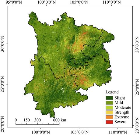
Figure 2 Spatial distribution map of soil erosion
modulus in 2010
This study is based on
the RUSLE model simulation of annual average soil erosion modulus of
southwestern mountainous region from 2000 to 2015, which is 13.25?C24.60 (tžhm?C2ža?C1). Compared with existing studies, the soil
erosion modulus estimated in this study is within the normal fluctuation range
(Table 3). Table 4 lists the ranges of the soil erosion modulus for different
land-use types simulated by some models in existing studies. Compared with
them, the average annual soil erosion modulus of forestland simulated in this
study is 15.92 tžhm?C2ža?C1, average annual soil erosion modulus of
grassland is 19.84 tžhm?C2ž a?C1, average annual soil erosion modulus of
cultivated land is 21.97 tžhm?C2ža?C1, and annual average soil erosion modulus of
residential land is 0.37 tžhm?C2ža?C1. The data obtained in this study are in good
agreement with the existing data, which shows that the soil erosion modulus
data generated in this study are more reliable.
Table 3 Comparison
of soil erosion modulus of different studies in different regions in
southwestern region with this dataset (tžhm?C2ža?C1)
|
Study area
|
Years
|
Research
method
|
Soil erosion
modulus
|
References
|
Soil erosion modulus
calculated in this dataset
|
|
Chengdu
|
The annual average
|
SCSLE
|
2.93
|
Liu, B, T., et al.
[23]
|
1.70?C28.86
|
|
Yuanyang County
|
2005?C2015
|
RUSLE
|
6.54?C17.81
|
Chen, F., et al.
[24]
|
12.36?C50.59
|
|
Karst trough area
|
2000?C2015
|
CA-Markov
|
1.04?C21.61
|
Cao, Y., et al.[25]
|
18.49
|
|
Jianchuan County
|
The annual average
|
RUSLE
|
12.56
|
Wei, X, L., et al.[26]
|
9.47?C38.01
|
|
Guizhou Province
|
The annual average
|
RUSLE
|
23.50
|
Niu, L, N., et al.
[27]
|
23.48
|
Table 4 Comparison of
soil erosion modulus of various land-cover types in this dataset with the
simulation results of other studies (tžhm?C2ža?C1)
|
Research method
|
Land-cover type
|
Period
|
Area
|
|
Woodland
|
Grassland
|
Arable land
|
Residential land
|
|
CSLE model[28]
|
4.59
|
5.23
|
35.36
|
3.73
|
1981?C2010
|
Guizhou province
|
|
RUSLE model[29]
|
5.99
|
?C
|
43.75
|
0
|
1962?C2012
|
Lingjiaotang small watershed in the Three Gorges Reservoir
area
|
|
137Cs Tracer[30]
|
?C5.22?C5.16
|
9.91?C16.16
|
7.27?C24.89
|
?C
|
2018
|
Small watershed in southern Yunnan
|
|
137Cs Tracer[31]
|
9.29
|
?C
|
25.37
|
?C
|
Annual average
|
Sangyong valley
|
|
this research
|
12.61
|
20.01
|
32.51
|
0.37
|
Annual average
|
Southwestern mountains
|
5 Discussion and Conclusion
This
dataset is based on integrating data on meteorological, soil, topography,
vegetation index and soil cover data, using a modified soil-loss model to sort
out and calculate the annual soil erosion modulus dataset with a resolution of
1 km in southwestern mountainous region.
Author Contributions
Chen, P, F. designed the methodology of the dataset. Wang
J, Y. contributed to the data processing and analysis and wrote the data paper.
Zhu, Y, Q. revised the data paper.
Conflicts of Interest
The authors declare no conflicts of interest.
References
[1]
Huang, M.
Z., Lan, J. C., Wen, L. X., et al.
Response of soil quality to different ecological restoration models in a karst
rocky desertification area [J]. Journal
of Forest and Environment, 2021, 41(2): 148?C156.
[2]
Luo, X. L.,
Wang, S. J., Bai, X. Y., et al.
Analysis on the spatio-temporal evolution process of rocky desertification in
Southwest Karst area [J]. Acta Ecologica
Sinica, 2021, 41(2): 680?C693.
[3]
Mohammad,
A. G., Adam, M. A. The impact of vegetative cover type on runoff and soil erosion
under different land uses [J]. Catena,
2010, 81(2): 97?C103??
[4]
Ye, X.
Study on Temporal and Spatial Patterns of Soil Erosion in Southwest Mountainous
Areas from 2000 to 2015 [J]. China
Resources Comprehensive Utilization, 2019, 37 (11): 176?C184, 196.
[5]
Wischmeier,
W. H., Smith, D. D. Rainfall energy and its relationship to soil loss [J]. Transactions of the American Geophysical
Union, 1958, 39(2): 285?C291.
[6]
Renard, K.
G., Foster, G. R., Weesies, G. A., et al.
Predicting soil erosion by water: a guide to conservation planning with the
revised universal soil loss equation (RUSLE) [Z]. USDA Agriculture Handbook,
703, 1997.
[7]
Christine,
A., Pasquale, B. K., et al. Using the
USLE: Chances, challenges and limitations of soil erosion modeling [J]. International Soil and Water Conservation
Research, 2019, 7(3): 203?C225.
[8]
Omar, D.,
Mahmoud, H., Oussama, B., et al.
Comparison of the erosion prediction models from USLE, MUSLE and RUSLE in a
Mediterranean watershed, case of Wadi Gazouana (N-W of Algeria) [J]. Modeling Earth Systems and Environment,
2019, 5(2): 725?C743.
[9]
Huang, J.
Yao., Z, H., Cha, S. X., et al.
Progress of study on soil and water conservation measure factors in USLE/RUSLE
[J]. Soil and Water Conservation in China,
2020(3): 37?C39, 56, 5.
[10]
Wang, J.
Y., Zhu Y. Q., Chen, P. F. 1 km raster dataset of annual soil erosion modulus
in southwestern mountainous region of China (2000?C2015) [J/DB/OL]. Digital Journal of Global Change Data
Repository, 2021. https://doi.org/10.3974/geodb.2021.04.04.V1.
[11]
GCdataPR
Editorial Office. GCdataPR data sharing policy [OL].
https://doi.org/10.3974/dp.policy.2014.05 (Updated 2017).
[12]
Chen, H.,
Jiang., X, C., Ren, L., et al.
Quantitative evaluation of soil erosion in the Huaihe River basin based on RUSLE
model [J]. Chinese Journal of Soil
Science, 2021, 52(1): 165?C176.
[13]
Ma, Z. Z.
Discussion on the method of estimating the value of various factors of general
soil loss equation using satellite images [J]. Soil and Water Conservation in China, 1989(3): 24?C27.
[14]
Williams,
J., Renardkg, K. G., Dyke, P. T. EPIC: a new method for assessing erosion??s
effect on soil productivity [J]. Journal
of Soil and Water Conservation, 1983, 38(5): 381?C383.
[15]
McCool, D.
K., Brown, L. C., Foster, G. R., et al.
Revised slope steepness factor for the Universal Soil Loss Equation [J]. Transactions of the ASAE, 1987, 30(5):
1387?C1396.
[16]
Liu, B. Y.,
Zhang, L. L., Jiao, J. Y. Soil erodibility and its use in soil erosion
prediction model [J]. Journal of Natural
Resources, 1999, 21(4): 345?C350.
[17]
Ran, C. H.
Evolution of soil erosion in the inland of the Three Gorges Reservoir area
based on the RUSLE [J]. Ecology and
Environmental Monitoring of Three Gorges, 2021, 6(1): 1?C18.
[18]
Liu, A. X.,
Wang, J., Liu, Z. J. Remote sensing quantitative monitoring of soil erosion in
Three Gorges Reservoir area GIS/RUSLE-based research [J]. Journal of Natural Disasters, 2009, 18(4): 25?C30.
[19]
Cai, C. F.
Study of applying USLE and geographical information system IDRISI to predict
soil erosion in small watershed [J]. Journal
of Soil Water Conservation, 2000, 14(12): 19?C24.
[20]
Feng, X.,
Liu, G., Chen, J. M., et al. Net
primary productivity of China??s terrestrial ecosystems from a process model
driven by remote sensing [J]. Journal of
Environmental Management, 2007, 85(3): 563?C573.
[21]
Fischer,
G., Nachtergaele, F., Prieler, S., et al.
Global agro-ecological zones assessment for agriculture (GAEZ 2008) [R]. IIASA,
Laxenburg, Austria and FAO, Rome, Italy, 2008.
[22]
Ministry of
Water Resources of P. R. China. Active standards for classification and
gradation of soil erosion: SL 190??2007 [S]. 2007.
[23]
Liu, B. T.,
Song, C. F., Tao, H. P. Quantitative assessment of soil erosion of Chengdu city
[J]. Journal of Yangtze River Scientific
Research Institute, 2016, 33(9): 40?C47.
[24]
Chen,
F., Li., H. B. Spatial-temporal variations of soil erosion in Southern Yunnan
Mountainous area using GIS and RUSLE: a case study in Yuanyang county, Yunnan province,
China [J]. Chinese Journal of Applied
Ecology, 2021, 32(2): 629?C637.
[25]
Cao, Y.,
Wang, S. J., Bai, X. Y., et al.
Spatial-temporal evolution processes and simulation of future soil erosion
scenario in the karst valley of Southern China [J]. Acta Ecologica Sinica, 2019, 39(16): 6061?C6071.
[26]
Wei, X. L.,
Yan, X., Long, X, M., et al.
Quantitative evaluation of soil erosion at the basin of Jian Lake based on
RUSLE [J]. Shandong Agricultural Sciences,
2017, 49(1): 103?C106, 125.
[27]
Niu, L. N.,
Shao, Q. Q., Liu, G. B., et al.
Analysis on Spatiotemporal Characteristics and Factors of Soil Erosion in
Liupanshui City [J]. Journal of
Geo-information Science, 2019, 21(11): 1755?C1767.
[28]
Chen, M.
Q., Wei, X., Zhang, K. L., et al.
Analysis of the characteristics of soil and water loss in Guizhou province
based on CSLE [J]. Journal of Soil and
Water Conservation, 2017, 31(3): 16?C21, 26.
[29]
Ju, Z. S.,
Wen, A. B., Yan, D. C., et al.
Estimation of soil erosion in small watershed of the Three Gorges Reservoir region
based on GIS and RUSLE [J]. Earth and
Environment, 2015, 43(3): 331?C337.
[30]
Wang, Y. P.,
Zhou, Z. K., Teng, H. W. Characteristics of soil erosion and nutrient losses in
three land use patterns in the small watershed of southern Dianchi [J]. Research of Soil and Water Conservation,
2021, 28(1): 11?C18.
[31]
Niu, X. Y.,
Wang, Y. H., Yang, H., et al. Effects
of different land uses on soil erosion and soil nutrient variability in the
Shuanglong catchment of Dianchi watershed [J]. Research of Environmental Sciences, 2014, 27(9): 1043?C1050.