Earth Data Encyclopedia
Outline Data of the Khanka Lake
Chen, L. J.1* Liu, C.2 Shi, R. X.2
1. National Geomatics Center of China, Beijing 100830, China;
2. Institute of Geographic Sciences and Natural Resources Research, Chinese Academy of Sciences, Beijing 100101, China
Keywords: Khanka; Russia; China; Ramsar wetlands of international importance; data encyclopedia
|
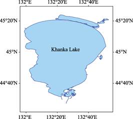
Figure 1 Map of the outline data of Khanka Lake (Ramsar site 112)
|
The Khanka Lake (or XingKai Lake) is the biggest lake in the Amur River basin, geo-located between 44°27′8″N and 45°23′57″N; 131°58′52″E and 132°52′56″E. One third area of the lake belongs to China (Heilongjiang province) and the two third belongs to Russia (Primorsky Krai). The lake is fed by several rivers, including Bolshiye Usashi River, Komissarovka River, Melgunovka River, Spasovka River. The only one outflow in the northeast of the lake is the Songacha River, it reaches the Ussuri River, and then to the Amur River. The Khanka Lake is consisted of two lakes, the small one in the north is 34.5 km wide and 4.5 km long with the depth of 1-5 meters. The big one is 71 km wide and 90 km long with the depth of 10 meters. There is a sand-blocking bar between them, which is about 1 km wide and 90 km long. The Khanka Lake is on the list of Ramsar wetlands of international importance (site 112) in 2001. The total area of the lake is 4,364.89 km2 and its outline is 662.39 km. The dataset is developed based on Google earth images, archived both in .kmz and .shp data format with the data size of 1.55 MB. The dataset can be accessed at: http://www.geodoi.ac.cn/WebEn/doi.aspx?Id=477.